
Iowa Illinois severe thunderstorms are the top convective concern in the NOAA Storm Prediction Center’s Day 1 Outlook issued at 05:58 UTC on August 13, 2026. The SPC has drawn a Slight Risk, the second of five severe categories (level 2 of 5), over a corridor that includes Des Moines, Cedar Rapids, Davenport, Iowa City, Peoria, Bloomington, Decatur, Danville, and Champaign.
Damaging winds are the primary hazard across that Slight Risk core, with hail and a brief tornado possible as secondary threats. SPC uses a five-tier system to communicate severe weather potential; see the iAlert guide to SPC outlook risk categories for a full breakdown.
Key points:
- Slight Risk (level 2 of 5) covers Des Moines, Cedar Rapids, Davenport, Iowa City, Peoria, Bloomington, Decatur, Danville, and Champaign.
- The 15% damaging wind probability for Iowa Illinois severe thunderstorms spans 49,220 square miles and 3.68 million people.
- A 2% tornado probability runs from eastern Iowa east to Indianapolis.
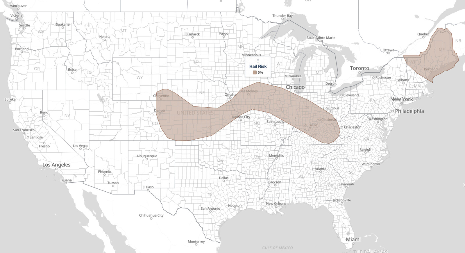
- A 5% large hail probability stretches from Denver to Cincinnati, with a separate area over northern New England.
- A mesoscale convective vortex over central Nebraska is holding the morning storm cluster together as it tracks east.
Get Lightning Detection Alerts for Your Location
When dangerous lightning is detected near your area, iAlert sends you an immediate notification by email, text message, or phone call, so you know when to seek shelter and when it is safe to head back outside.
Sign Up for Lightning Detection Alerts →Where Iowa Illinois Severe Thunderstorms Are Expected
The Slight Risk zone for Iowa Illinois severe thunderstorms sits squarely over central and eastern Iowa and central and northern Illinois. Des Moines, Cedar Rapids, Davenport, Iowa City, Peoria, Bloomington, Decatur, Danville, and Champaign all fall inside it. These cities face the greatest exposure to organized, potentially damaging storms on August 13.
Springfield, Illinois sits just outside the Slight Risk boundary but still carries the same 15% damaging wind probability as the cities inside it. Treat Springfield as part of the threat corridor, not as an outlying area.
A broader Marginal Risk, the first of five severe categories (level 1 of 5), wraps around that core. It extends east into Joliet, Lafayette, Terre Haute, Indianapolis, Dayton, Cincinnati, Lexington, Evansville, and Louisville, and west across the central Plains through Omaha, Lincoln, Grand Island, Topeka, Salina, Wichita, and Dodge City to Denver, Colorado Springs, and Cheyenne.
Two additional Marginal Risk areas sit well outside the Iowa Illinois severe thunderstorms corridor and are driven by separate weather features. One covers the Great Basin, including Las Vegas and Salt Lake City. The other covers northern New England, including Portland, Maine and Burlington, Vermont.
The SPC assigns a 15% damaging wind probability to the Slight Risk cities in Iowa and Illinois, an area of 49,220 square miles holding roughly 3.68 million people. That figure means there is a 15% chance of at least one damaging wind report within 25 miles of any point in that zone. It is a probability of occurrence, not a wind speed.
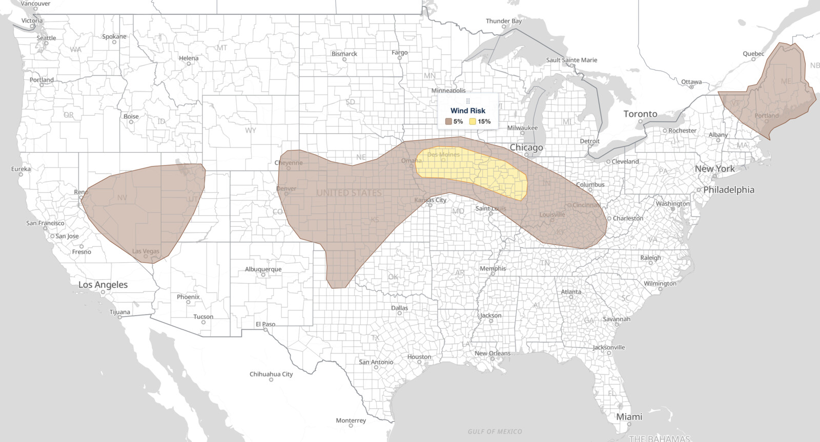
A 5% damaging wind probability covers the far larger Marginal footprint, 488,557 square miles and 32.5 million people across three separate areas. The SPC names Indianapolis, Denver, Las Vegas, Omaha, and Colorado Springs as its largest population centers.
Large hail runs on a different footprint than wind, and this is where the two hazards separate. The 5% large hail probability covers 311,696 square miles, notably smaller than the wind area, and it skips the Great Basin entirely. It runs from Denver, Aurora, Colorado Springs, and Cheyenne east across Topeka, Salina, and Dodge City, through the Iowa and Illinois Slight Risk cities, and on to Indianapolis, Dayton, Cincinnati, Lexington, and Louisville.
Omaha, Lincoln, Wichita, and Evansville sit inside the 5% wind area but outside the hail area, so wind is the only listed hazard there. A second, unconnected 5% hail area covers northern New England.
A 2% tornado probability covers 68,637 square miles and about 6.99 million people. It takes in every Slight Risk city plus Springfield, Illinois, and extends east past the categorical boundary into Lafayette, Terre Haute, and Indianapolis. The tornado footprint for these Iowa Illinois severe thunderstorms is actually larger than the Slight Risk itself, reaching farther east into Indiana.
Meteorologist’s Take on Iowa Illinois Severe Thunderstorms
The driver behind today’s Iowa Illinois severe thunderstorms is a mesoscale convective vortex, or MCV, that developed early this morning over central Nebraska. An MCV is a mid-level spin-up left behind by a prior round of storms; it acts as a weak organizing focus that can keep a cluster of thunderstorms alive well past sunrise.
According to the SPC, that cluster was spreading east through the morning and was expected to be in the western and central Iowa vicinity by the start of the outlook period at 12z (8:00 a.m. EDT / 7:00 a.m. CDT).
The SPC notes meaningful uncertainty about how intense the cluster will be. Fairly substantial convective inhibition, a capping layer of warm air aloft that resists storm initiation, sits downstream into Iowa and could blunt it.
Working against that cap is warm, moist air advancing northward on a low-level jet over the southern and central Plains. Combined with a moist and unstable air mass already in place over Iowa, that gives the cluster enough fuel to produce scattered damaging winds as it pushes east through the morning. If individual cells stay rooted at the surface rather than lofting into elevated convection, a brief embedded tornado is also possible.
The SPC flags even greater uncertainty for the afternoon, with most guidance showing the cluster weakening as it crosses into Indiana. The air mass downstream and south of the morning outflow is still expected to destabilize through the day, so any new storms that fire could deliver isolated damaging winds and some hail given the strong buoyancy in the forecast.
In plain terms: a leftover storm spin-up is dragging an active cluster eastward across Iowa this morning. Wind damage is the most likely outcome for Iowa Illinois severe thunderstorms as the cluster progresses. A tornado is a lower-probability but real possibility while storms remain surface-based.
By afternoon the threat shifts toward isolated, pulse-type storms capable of wind gusts and hail. Forecasters watching Iowa Illinois severe thunderstorms through that period will be looking for any new surface-based development along the morning outflow boundary.
Risk Areas Outside the Iowa Illinois Severe Thunderstorms Corridor
The Marginal Risk over the southern and central High Plains has a different cause. High-based thunderstorms are expected to form over the central Rockies and Front Range this afternoon, then spread east-northeast into greater instability, with consolidating outflows supporting isolated severe gusts and occasional hail. Modest deep-layer shear is the reason SPC held the probabilities down rather than raising them across eastern Colorado and Kansas.
Over the Great Basin, modestly enhanced southwesterly mid-level flow and afternoon heating should fire scattered to numerous thunderstorms capable of strong to severe gusts. The SPC expanded that Marginal Risk based on 00Z HREF guidance. In the Northeast, a mid-level trough dropping out of Quebec brings cool air aloft and strong west-northwesterly flow, enough for isolated damaging winds and hail despite limited instability.
How to Stay Safe During Iowa Illinois Severe Thunderstorms
Because damaging wind is the lead hazard in today’s Iowa Illinois severe thunderstorms, the most important step is to stay inside a sturdy building when warnings are issued. Wind gusts from a bowing cluster can arrive with very little warning, especially in the pre-dawn and morning hours when storms may already be ongoing. Move away from windows and large glass surfaces.
Hail is a secondary hazard with today’s Iowa Illinois severe thunderstorms. If you are outdoors or driving when large hail falls, take shelter inside a solid structure rather than relying on a vehicle alone, since hail can shatter glass. Avoid parking under trees, which can shed branches in gusty winds.
Given the 2% tornado probability across the corridor, know your shelter location in advance. Interior rooms on the lowest floor of a well-built structure offer the best protection. Monitor active weather alerts throughout the morning and afternoon, and keep live radar accessible so you can track the cluster’s eastward progress in real time.
Iowa Illinois Severe Thunderstorms FAQ
Where is the highest risk on August 13, 2026?
The Slight Risk zone, the highest risk level in today’s outlook, covers Des Moines, Cedar Rapids, Davenport, Iowa City, Peoria, Bloomington, Decatur, Danville, and Champaign. These cities face the greatest chance of organized severe thunderstorms.
What is the damaging wind probability for the core Iowa Illinois zone?
The SPC places a 15% damaging wind probability over the Slight Risk cities in Iowa and Illinois, plus Springfield, Illinois. That means a 15% chance of at least one damaging wind report within 25 miles of a given point, not a specific wind speed.
Are tornadoes expected with these Iowa Illinois severe thunderstorms?
A brief embedded tornado is possible. The SPC assigns a 2% tornado probability to the Iowa and Illinois core and east into central Indiana, a real but low-end risk tied to whether storms can remain surface-based during the morning hours.
Is large hail expected with the Iowa Illinois severe thunderstorms?
Yes, at a 5% probability. The hail area covers the Slight Risk cities but runs on a wider east-west axis than the wind threat, from the Colorado Front Range to Cincinnati and Louisville. Omaha, Lincoln, and Wichita are inside the wind area but outside the hail area.
When will storms arrive and how long will the threat last?
The MCV-driven cluster was expected to reach western and central Iowa by 12z (8:00 a.m. EDT / 7:00 a.m. CDT) and push eastward through the morning. Additional storm potential continues into the afternoon as the air mass destabilizes, though the cluster itself may weaken entering Indiana.
Sources:
- NOAA Storm Prediction Center, Day 1 Convective Outlook, issued 05:58 UTC August 13, 2026 (archived)
- NOAA Storm Prediction Center, current Day 1 Convective Outlook
Get Severe Weather Alerts for Your Location
When any NWS watch, warning, or advisory is issued for your area, iAlert sends you an immediate notification by email, text message, or phone call, 24 hours a day, 7 days a week.
Sign Up for Severe Weather Alerts →

