
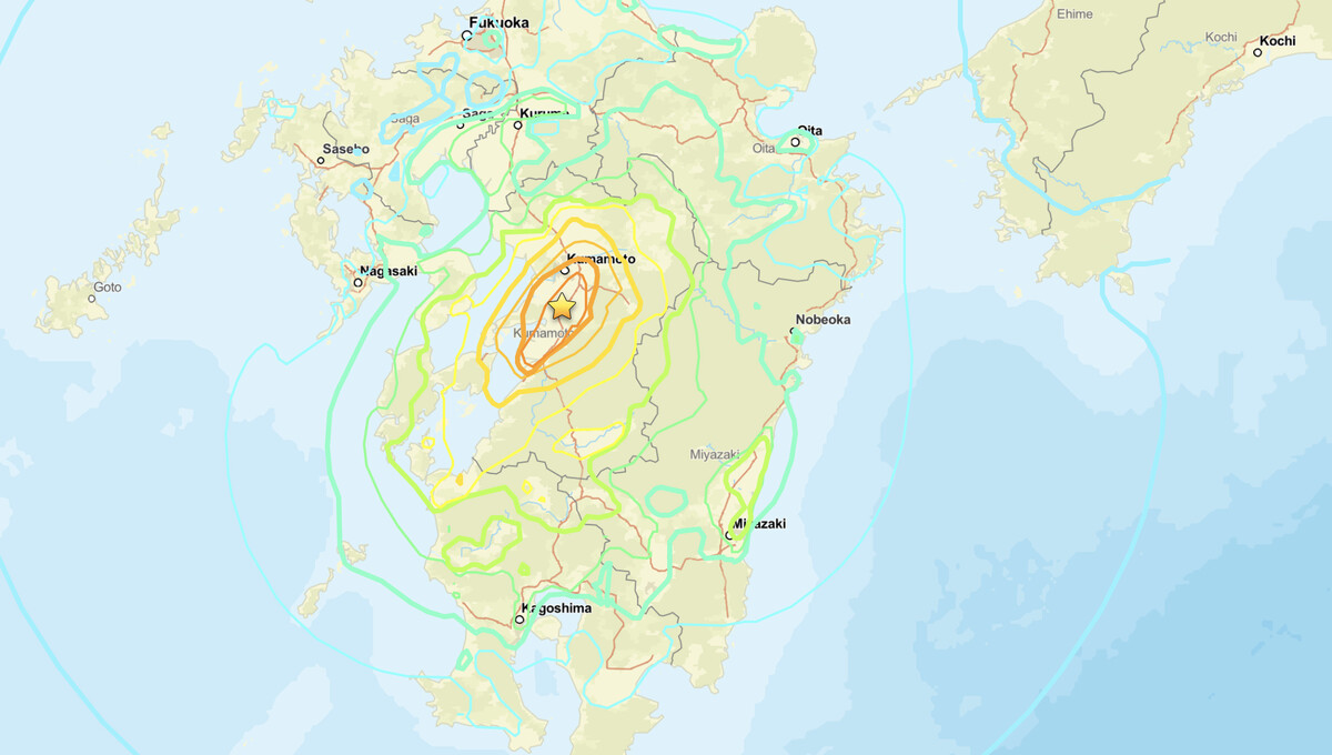
Japan earthquake activity reached a dangerous threshold on July 28, 2026, when a magnitude 6.8 struck approximately 5 kilometers east of Uto, in Kumamoto Prefecture on the island of Kyushu. The United States Geological Survey assigned the event a Red PAGER alert, its highest impact tier. The USGS ShakeMap model placed peak ground shaking at Modified Mercalli intensity IX, the level described as violent, and public Did You Feel It? reports from the region reached the same tier.
Key points:
- Magnitude 6.8 Japan earthquake struck 5 km east of Uto at 07:27 UTC on July 28, 2026, or 16:27 JST.
- USGS issued a Red PAGER alert, the highest of its four impact tiers.
- ShakeMap peak intensity reached 8.5 and Did You Feel It? reached 9.1, both rounding to intensity IX, or violent shaking.
- Epicenter located at 32.682°N, 130.722°E at a shallow depth of 10 km.
- The USGS record for this Japan earthquake carries no tsunami flag. The Japan Meteorological Agency is the authority on any coastal advisory.
What the Japan Earthquake Data Tells Us
The USGS placed the Japan earthquake epicenter at coordinates 32.682°N, 130.722°E, with a focal depth of just 10 kilometers, or about 6.2 miles. Origin time was 07:27:15 UTC, which is 16:27 JST, late afternoon local time. Shallow earthquakes like this one release their energy close to the surface, which concentrates destructive shaking into the area immediately around the rupture rather than spreading it thinly over a wide region.
Uto sits on the Uto Peninsula, a narrow arm of land on the west side of Kumamoto Prefecture between the Ariake and Yatsushiro seas. This is the same region that absorbed severe damage during the 2016 Kumamoto earthquake sequence, when a magnitude 7.0 mainshock followed a strong foreshock roughly a day earlier. The building stock, the terrain, and the fault system are all familiar quantities here, and none of them favor a mild outcome from a shallow Japan earthquake of this size.
The PAGER (Prompt Assessment of Global Earthquakes for Response) system is a USGS tool that rapidly estimates fatality and economic loss ranges from shaking intensity, local building stock, and population density. Its four tiers run green, yellow, orange, and red. Red is the top tier, triggered when the model estimates 1,000 or more fatalities or economic losses above $1 billion. That is worth stating precisely, because an estimate in the hundreds would produce an Orange alert, not a Red one. PAGER is a model output generated within minutes of the event, not a count of confirmed casualties, and it is revised as ground truth arrives.
Intensity IX on the Modified Mercalli scale carries the label violent. At that level, well designed structures are thrown out of plumb, substantial buildings sustain major damage with partial collapse, and buildings can shift off their foundations. Two caveats belong alongside those numbers. The ShakeMap peak of 8.5 sits directly on the boundary between VIII and IX, so a modest revision could move the published Roman numeral either direction. The Did You Feel It? value of 9.1 rests on a small early sample of citizen reports, and in a small sample a single respondent close to the rupture pulls the maximum upward. Both products are recomputed as more data arrives.
Meteorologist’s Take
The July 28 Japan earthquake is a geophysical rather than a meteorological event, but seismic hazard and weather safety intersect in ways worth naming. Coastal Kyushu sits in an active typhoon corridor. A community holding damaged roofs, cracked walls, and blocked roads is far more exposed if heavy rain or a tropical system arrives in the days that follow, because drainage fails faster, shelter integrity is already compromised, and emergency access narrows.
The specific compounding risk here is slope failure. Strong shaking loosens hillsides without immediately collapsing them, and the next heavy rainfall event is what mobilizes that loosened material into debris flows. Kumamoto has seen exactly this pattern before. Anyone tracking the recovery should be watching the rainfall forecast for Kyushu as closely as the aftershock feed, and iAlert’s weather analysis tools are built for precisely that kind of overlapping hazard picture.
The shallow 10 km depth remains the single most important physical factor. Seismic waves have little distance over which to attenuate before reaching the surface, which is why the modeled peak intensity runs so high directly above the rupture. Peak intensity applies to the immediate epicentral area, not to the entire contoured region. Shaking falls off quickly with distance, and that falloff is exactly what the concentric ShakeMap contours are showing.
Aftershocks following a magnitude 6.8 are a certainty rather than a possibility. Empirically, the largest aftershock in a sequence tends to fall roughly 1.2 magnitude units below the mainshock, a pattern known as Bath’s law, which puts a typical largest aftershock near magnitude 5.6 in this case. The 2016 sequence in this same prefecture is the cautionary example, because the event first read as the mainshock turned out to be a foreshock. Residents in the Uto area and the broader Kumamoto Prefecture should treat this sequence as ongoing, not concluded.
How to Stay Safe After the Japan Earthquake
If you are in or near the affected area of the Japan earthquake, the immediate priority once shaking stops is to check for structural damage before re-entering any building. Gas leaks, broken water mains, and downed power lines are the serious secondary hazards after a shallow, high-intensity Japan earthquake, and they cause casualties well after the ground stops moving.
On tsunamis: the USGS event record carries no tsunami flag for this earthquake, and a shallow crustal rupture at the coastline is not a typical tsunami source. The Japan Meteorological Agency is the authoritative voice on any advisory in Japanese coastal waters. Follow JMA directly rather than third-party aggregators on that question, and follow local emergency management authorities on evacuation and shelter.
Aftershocks in this sequence can reach magnitude 5 or higher and may dislodge debris already loosened by the mainshock. Avoid damaged structures until a professional inspection clears them, because a building that survived the mainshock is not necessarily safe against the next one. Keep emergency communication devices charged and accessible, and monitor active weather alerts on iAlert if you are tracking compounding weather hazards alongside the seismic event.
Japan Earthquake FAQ
What magnitude was the Japan earthquake near Uto?
The earthquake measured magnitude 6.8. The USGS recorded it at a shallow depth of 10 km, approximately 5 km east of Uto, Japan, at 07:27 UTC on July 28, 2026, which is 16:27 JST.
What does the Red PAGER alert mean?
Red is the highest of the four USGS PAGER impact tiers. It is issued when the model estimates 1,000 or more fatalities or economic losses exceeding $1 billion. It is a rapid estimate based on shaking intensity, population density, and local building stock, not a confirmed casualty count.
How strong was the shaking near the epicenter?
The USGS ShakeMap peak reached 8.5 and Did You Feel It? reports reached 9.1, both corresponding to Modified Mercalli intensity IX, described as violent shaking. That peak applies to the immediate epicentral area east of Uto. Intensity drops off with distance from the rupture.
Did the Japan earthquake generate a tsunami?
The USGS event record carries no tsunami flag for this event, and a shallow crustal rupture at the coast is not a typical tsunami source. The Japan Meteorological Agency issues the official advisories for Japanese coastal waters and is the source to check for any change.
Should residents expect aftershocks?
Yes. Aftershocks are expected following a magnitude 6.8 mainshock, and the largest typically falls around 1.2 magnitude units below it, near magnitude 5.6 here. Some can exceed magnitude 5.0 and may cause additional damage to already weakened structures. Because this Japan earthquake struck at such a shallow depth, even moderate aftershocks carry elevated damage potential for compromised buildings.
Sources:


