
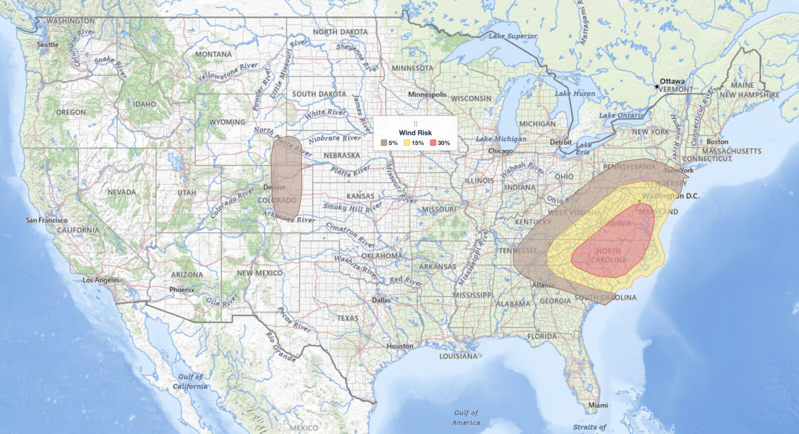
Mid-Atlantic severe thunderstorms are the main weather story on Tuesday, July 28, 2026. The NOAA Storm Prediction Center has placed Virginia, Maryland, Delaware, the Washington D.C. area, parts of southern Pennsylvania and New Jersey, and nearly all of North Carolina under a Slight Risk, level 2 of 5 on the SPC severe scale, with damaging wind probabilities reaching 30% over central Virginia into central North Carolina.
An isolated tornado is possible with supercell storms during the afternoon, and large hail is in play with the strongest cells. A Marginal Risk, level 1 of 5, wraps the Slight area west into West Virginia, Kentucky, Tennessee and northern Georgia, and south across the rest of South Carolina.
Key points:
- Slight Risk (level 2 of 5) covers the Mid-Atlantic and the Carolinas on July 28, 2026.
- Mid-Atlantic severe thunderstorms carry a 30% damaging wind probability; tornado and large hail sit at 5% each.
- Strongest instability is forecast from southeastern Virginia into central North Carolina.
- Storms develop around midday in the higher terrain, then expand southward through the afternoon.
- A separate hail and wind threat sits over the central High Plains, including eastern Colorado.
Where Mid-Atlantic Severe Thunderstorms Will Hit Hardest
The SPC singles out southeastern Virginia into central North Carolina as the hotspot. Mixed-Layer CAPE, the amount of energy available to a rising thunderstorm updraft, could peak near 3,000 J/kg by mid-afternoon. That is a lot of fuel. Surface dewpoints in the lower to mid 70s°F will be in place across the region, feeding that instability ahead of an approaching cold front.
Mid-Atlantic severe thunderstorms are not confined to that corridor. The wind threat also reaches west into the Appalachian foothills, including west-central North Carolina and far northern South Carolina, where organized lines of storms can produce damaging gusts well away from the primary supercell zone.
Population centers inside the Slight Risk include Washington D.C., Baltimore, Richmond, Norfolk, Raleigh, Greensboro, Charlotte and Wilmington. If you live anywhere from the Northern Neck of Virginia south through the North Carolina Piedmont, plan on watching the sky and your phone from lunchtime onward.
SPC uses a five-tier scale to communicate severe weather potential. For a full breakdown of what each level means, read the iAlert severe weather outlook explainer.
Meteorologist’s Take on the Mid-Atlantic Severe Thunderstorms Setup
The large-scale driver is an upper-level trough digging south-southeastward into the eastern United States, dragging a cold front into the central Appalachians. That forces lift into a warm, humid airmass already loaded with instability. Storms should fire first around midday over the higher terrain of northern Virginia and Pennsylvania, then expand and track southward through the rest of Virginia into North Carolina during the afternoon.
The wind shear profile is what concerns forecasters most. The SPC notes 0-6 km shear in the 40 to 50 knot range, strong enough to organize discrete supercells rather than a disorganized cluster. On top of that, 0-3 km storm-relative helicity is forecast near 225 m²/s² by mid-afternoon.
That low-level helicity is the tornado ingredient. In plain terms: winds change both speed and direction sharply with height near the ground, and an updraft moving through that layer starts to rotate. Add 3,000 J/kg of instability and a few of those rotating storms can put down a brief tornado. That is what separates today’s Mid-Atlantic severe thunderstorms from a routine summer wind event.
Separately, the central High Plains will see scattered afternoon convection triggered by a subtle shortwave trough moving through a mid-level ridge, combined with terrain-forced lift. MLCAPE of 2,000 to 2,500 J/kg, 0-6 km shear near 30 knots, steep low-level lapse rates and temperature-dewpoint spreads near 30°F support isolated severe gusts and hail with the stronger cells over eastern Colorado and vicinity.
How to Stay Safe from Mid-Atlantic Severe Thunderstorms Today
The SPC flags three hazards for this event: damaging wind gusts, tornadoes and large hail. Match your preparation to those threats. If a tornado warning is issued for your county, move immediately to an interior room on the lowest floor of a sturdy building, away from windows. Do not wait to see or hear the tornado.
Damaging wind carries the highest probability today at 30%. Bring in or secure outdoor furniture, umbrellas, trash cans and anything else that can become a projectile, and charge your phone before storms arrive in case of a power cut. Large hail can shatter windows and dent vehicles in seconds, so park under cover if cells are approaching.
Track conditions in real time with live radar and active weather alerts, and sign up for alerts so warnings reach you the moment the National Weather Service issues them for your county.
Mid-Atlantic Severe Thunderstorms FAQ
Where is the highest risk on July 28, 2026?
The SPC places the greatest threat from southeastern Virginia into central North Carolina, where MLCAPE could peak near 3,000 J/kg and supercells are most likely to form. That same corridor holds the 30% damaging wind probability.
Which cities are in the Slight Risk area?
Washington D.C., Baltimore, Richmond, Norfolk, Raleigh, Greensboro, Charlotte and Wilmington all fall inside the Slight Risk, along with most of Virginia, Maryland, Delaware and North Carolina.
How strong could wind gusts get?
The SPC assigns a 30% damaging wind probability across the core of the risk area. The discussion does not name a peak gust, but the severe threshold for wind is 58 mph or higher.
Are tornadoes expected today?
Yes. The SPC indicates an isolated tornado threat tied to supercells and assigns a 5% tornado probability. Strong low-level shear and helicity near 225 m²/s² support that risk.
When will storms arrive?
Mid-Atlantic severe thunderstorms should first develop around midday near the higher terrain of northern Virginia and Pennsylvania, then expand southward through the rest of Virginia and into North Carolina during the afternoon and evening.
Sources:
Get Severe Weather Alerts for Your Location
When any NWS watch, warning, or advisory is issued for your area, iAlert sends you an immediate notification by email, text message, or phone call, 24 hours a day, 7 days a week.
Sign Up for Severe Weather Alerts →

