
Plains severe thunderstorms are the primary concern today, July 30, 2026, as the NOAA Storm Prediction Center has issued a Slight Risk covering parts of the central and northern Plains. SPC rates this a Slight Risk, the second of five severe categories (level 2 of 5), with damaging wind gusts as the headline hazard from eastern South Dakota into central Nebraska.
Key points:
- Slight Risk (level 2 of 5) in effect for the central and northern Plains on July 30.
- Highest threat centered from eastern South Dakota southwestward to central Nebraska.
- Primary hazard is damaging wind gusts; large hail is the secondary threat in the High Plains.
- SPC places the damaging wind probability at 15% in the Slight Risk core and 5% across the surrounding Marginal Risk.
- A separate 5% large hail probability runs from eastern Montana south into eastern Colorado.
- Storm activity expected this afternoon through early to mid evening.
Where Plains Severe Thunderstorms Are Most Likely Today
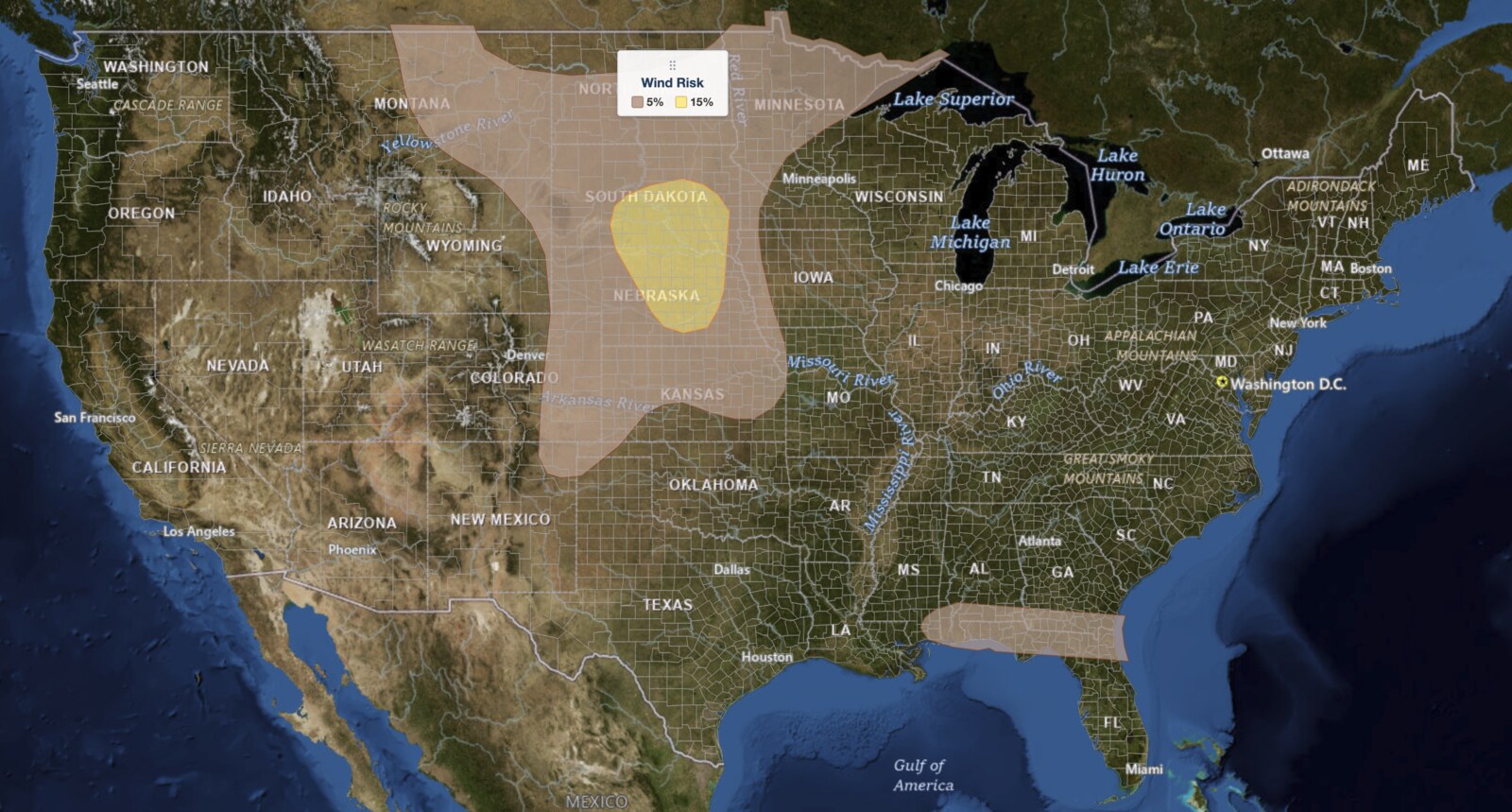
The Slight Risk area for today’s Plains severe thunderstorms focuses on a corridor running from eastern South Dakota, including the area near Huron, southwestward through central Nebraska near Grand Island. This is the zone where conditions are expected to combine most explosively this afternoon. Cities such as Huron, South Dakota and Grand Island, Nebraska sit squarely inside the area of greatest concern.
A broader Marginal Risk, level 1 of 5, wraps around that core and stretches from eastern Montana and the Dakotas south through Nebraska and Kansas. Instability in the High Plains portion of that area is more isolated, but localized strong to severe wind gusts and hail remain possible during the mid to late afternoon as storms drop into lower elevations. A separate Marginal Risk strip runs along the Gulf Coast, where isolated severe gusts are possible.
SPC uses a five-tier system to communicate severe weather potential; you can read a full breakdown of the SPC outlook risk categories for details on what each level means.
The probability maps sharpen that picture. SPC draws a 15% damaging wind probability over the Slight Risk core in eastern South Dakota and central Nebraska, and a 5% wind probability across the much larger surrounding area and along the Gulf Coast. A 15% wind probability means there is a 15 percent chance of a damaging wind report within 25 miles of any given point. That is a probability, not a wind speed. The 5% large hail probability sits farther west, tracing a north to south corridor from eastern Montana through western South Dakota and western Nebraska into eastern Colorado, which is why hail is the western half of today’s Plains severe thunderstorms and wind is the eastern half.
Meteorologist’s Take on Today’s Plains Severe Thunderstorms
The setup for today’s Plains severe thunderstorms starts at the mid-levels of the atmosphere, where a shortwave ridge pushes east into the upper Mississippi Valley while a shortwave trough and its accompanying cold front sweep through the northern Plains. That frontal boundary is the key trigger: surface moisture pooling ahead of it will push dew points into the lower 70s Fahrenheit, fueling moderate instability as the morning progresses.
By early afternoon, SPC expects storms to fire along the front and grow in coverage through the afternoon. Model soundings between Huron, South Dakota and Grand Island, Nebraska show mixed-layer CAPE (a measure of atmospheric fuel) in the 1,500 to 2,000 joules per kilogram range, with wind shear through the lowest six kilometers of the atmosphere running 25 to 35 knots. That combination is enough to support both discrete supercells and organized line segments, making storm mode unpredictable but wind damage the consistent thread. An MCS, a large organized cluster of storms, may consolidate during late afternoon and early evening, then drift southward into the central Plains and keep the threat alive into the mid evening hours.
Farther west across the High Plains, large-scale lift is weaker, but terrain helps coax storms to life in the afternoon. Those storms track southeast toward lower terrain, bringing the hail and wind threat with them. That is the corridor covered by the 5% hail probability. The Gulf Coast threat is more modest, tied to a different and more localized setup, and SPC held it inside the 5% wind probability rather than raising it toward the Plains numbers.
How to Stay Safe During Plains Severe Thunderstorms
Because damaging wind gusts are the primary hazard in today’s Plains severe thunderstorms, take steps now to reduce wind-related risks before storms arrive this afternoon. Bring in or secure outdoor furniture, canopies, and unsecured equipment that could become airborne in strong gusts.
If a severe thunderstorm warning is issued for your county, move inside a sturdy building immediately and stay away from windows. Downed power lines are a serious risk after wind damage events; treat any downed line as energized and keep your distance. Check active weather alerts and your local weather forecast frequently this afternoon so you are not caught off guard as storms develop quickly near the frontal boundary. If hail is forecast in your part of the High Plains, move vehicles under cover before storms arrive; hail can dent and crack windshields with little warning.
Plains Severe Thunderstorms FAQ
Where are Plains severe thunderstorms most likely on July 30?
The highest risk today is centered from eastern South Dakota, near Huron, southwestward into central Nebraska near Grand Island. That corridor is under the Slight Risk, level 2 of 5, according to SPC.
How strong could wind gusts get?
The SPC discussion identifies damaging wind gusts as the primary threat but does not specify an exact top gust speed. SPC places the probability of a damaging wind report at 15% inside the Slight Risk area, meaning gusts capable of causing damage are possible, not a guaranteed measured speed.
Is there a tornado threat today?
The SPC discussion for today’s Plains severe thunderstorms does not identify tornadoes as a primary threat. Wind damage and, to a lesser extent, large hail are the main concerns across the central and northern Plains.
When will storms develop and how long will the threat last?
Storms are expected to initiate near the cold front around midday, expand through the afternoon, and continue into the early to mid evening as a large storm cluster tracks southward into the central Plains.
Sources:
- NOAA Storm Prediction Center, Day 1 Convective Outlook, July 30, 2026
- NOAA Storm Prediction Center, Day 1 Probabilistic Wind Outlook, July 30, 2026
Get Severe Weather Alerts for Your Location
When any NWS watch, warning, or advisory is issued for your area, iAlert sends you an immediate notification by email, text message, or phone call, 24 hours a day, 7 days a week.
Sign Up for Severe Weather Alerts →

