
Mid-Atlantic severe thunderstorms are the focus of the NOAA Storm Prediction Center’s updated Day 1 Convective Outlook, issued 12:42 UTC (8:42 am EDT) on October 16, 2026. It keeps a Slight Risk, level 2 of 5 on the SPC severe scale, across parts of the Mid-Atlantic into southern New England. Philadelphia, Harrisburg, Scranton, Trenton, Newark, Wilmington, Baltimore, Washington, D.C., Hartford and New York City all sit inside that Slight Risk, where a low-topped line of storms is expected to bring scattered damaging winds this afternoon and early evening, with a localized tornado risk.
Key points:
- Slight Risk (level 2 of 5) from northern Virginia, Maryland and Pennsylvania into Connecticut and western Massachusetts.
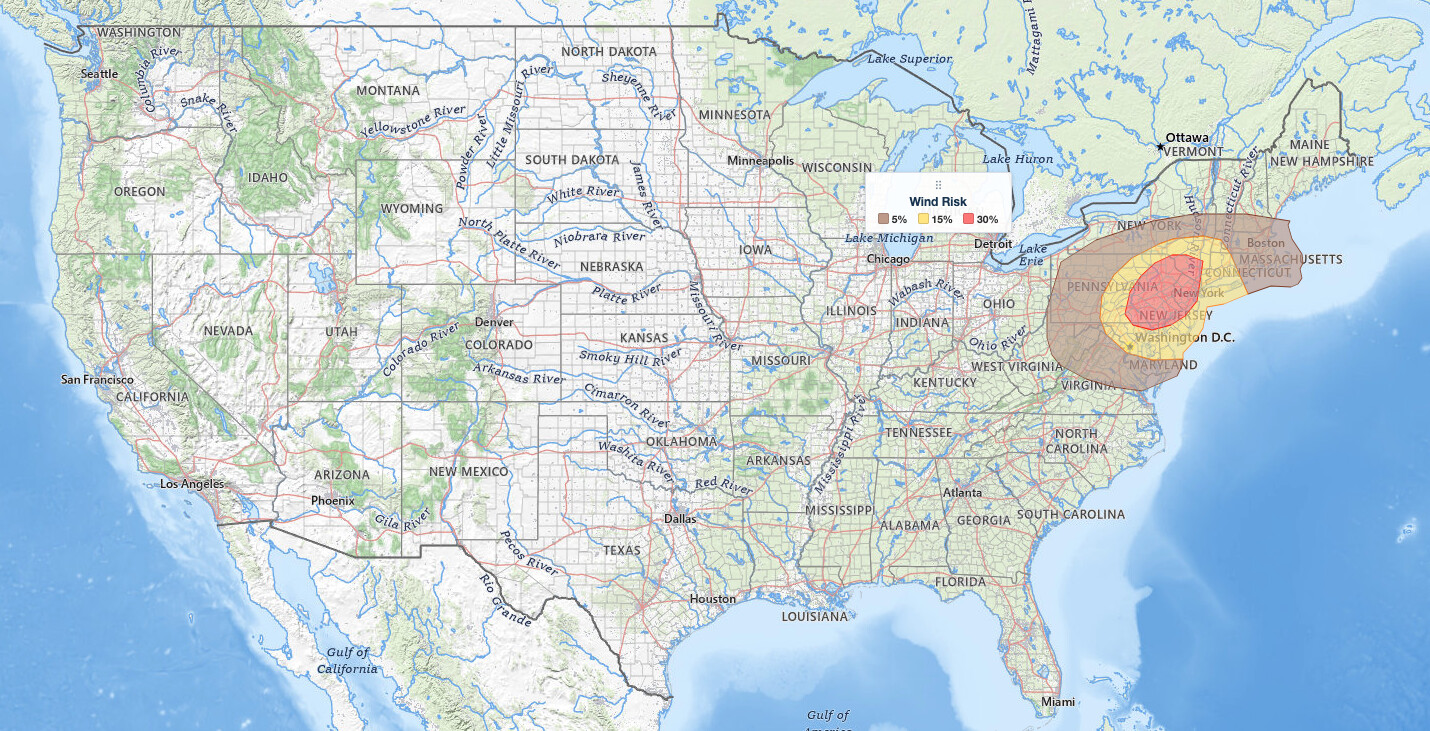
- SPC draws a 30% damaging wind probability over Philadelphia, Harrisburg, Allentown, Trenton and Poughkeepsie, an area home to about 17 million people.
- A 2% tornado probability covers New York City, Philadelphia, Scranton and Reading.
- A storm line is expected to organize over central and eastern Pennsylvania and southern New York between 1 pm and 5 pm EDT, then race east.
- No hail risk area is drawn for this event.
Get Severe Weather Alerts for Your Location
When any NWS watch, warning, or advisory is issued for your area, iAlert sends you an immediate notification by email, text message, or phone call, 24 hours a day, 7 days a week.
Sign Up for Severe Weather Alerts →Where the Mid-Atlantic severe thunderstorms risk is highest
The highest damaging wind probability, 30%, covers 21,851 square miles and about 17.0 million people across eastern Pennsylvania, New Jersey, northern Delaware and the lower Hudson Valley, according to the SPC’s area tables. Cities inside it include Philadelphia, Newark, Trenton, Camden, Princeton, Paterson, Allentown, Bethlehem, Reading, Lancaster, York, Harrisburg, Wilkes-Barre, Scranton, Poughkeepsie and Wilmington, Delaware. The SPC says the greatest coverage of damaging winds should focus on eastern Pennsylvania into New Jersey and southern New York, where instability is locally greater.
An SPC probability is the chance of at least one severe report within 25 miles of a point. It is not a wind speed.
A 15% damaging wind probability wraps around that core, covering 38,441 square miles and about 25.9 million people. Cities inside it include New York City, Washington, D.C., Baltimore, Hartford, New Haven, Bridgeport, Atlantic City, Dover, Annapolis, Hagerstown, Frederick, Leesburg, Arlington, Binghamton, Kingston, Islip and Pittsfield. These metros remain in the Slight Risk for Mid-Atlantic severe thunderstorms even though they sit outside the 30% wind area, so treat the wind threat there as real but somewhat lower.
A broader Marginal Risk, level 1 of 5, carries a 5% damaging wind probability over Boston, Pittsburgh, Richmond, Providence, Worcester, Albany, Springfield, Manchester, Morgantown and Elkins in West Virginia, Cumberland, Winchester, Charlottesville, Fredericksburg, Manassas and Salisbury, Maryland. The SPC uses a five-tier system to communicate severe weather potential, explained in our severe weather outlook explainer. Mid-Atlantic severe thunderstorms in the Marginal zone are less likely to turn severe, but isolated wind damage is still possible.
The tornado risk with these Mid-Atlantic severe thunderstorms is much narrower than the wind threat. A 2% tornado probability covers 29,342 square miles and about 22.4 million people, including New York City, Philadelphia, Newark, Allentown, Harrisburg, Scranton, Trenton, Wilmington, Camden, Princeton, Paterson, York, Lancaster, Reading, Poughkeepsie and Kingston. Washington, Baltimore, Hartford, New Haven, Bridgeport, Atlantic City, Dover, Annapolis and Hagerstown sit outside the tornado probability, with damaging wind the only drawn hazard there.
Beyond the severe risk areas, the SPC marks a General Thunderstorms area that includes Syracuse, Rochester, Buffalo, Youngstown, Charleston, West Virginia, Roanoke and Portland, Maine. That shading marks non-severe storms and is not one of the five severe categories.
Timing for the Mid-Atlantic severe thunderstorms
Isolated strong gusts were possible this morning with showers along the cold front across western Pennsylvania and New York, even with very limited instability. The main event follows: short-term guidance continues to show a low-topped line of storms developing across central into eastern Pennsylvania and southern New York between 17z and 21z (1:00 pm to 5:00 pm EDT).
From there, the line of Mid-Atlantic severe thunderstorms is expected to spread quickly east across the northern Mid-Atlantic and southern New England through early evening, with wind gusts strengthened by the storms themselves producing scattered damage. Expect one fast-moving band rather than an all-day threat; once the line passes your location, the severe risk is largely over.
An isolated threat for damaging winds and a brief tornado should reach toward the coast before the storms weaken this evening, as cooler marine air and nighttime cooling stabilize the lower atmosphere.
Meteorologist’s take
A deep, positively tilted upper-level trough stretching from eastern Canada into the Upper Midwest will amplify as it moves over the eastern United States today. A surface low over southern Ontario will track east-northeast into southern Quebec, and its trailing cold front will sweep east-southeast across the Mid-Atlantic and Northeast this afternoon into tonight. Strong west-southwesterly winds in will track east-northeast into southern Quebec, and its trailing cold front will sweep east-southeast across the Mid-Atlantic and Northeast this afternoon into tonight. Strong west-southwesterly winds in the lower and middle atmosphere will spread over the region ahead of it.
The thermodynamics behind these Mid-Atlantic severe thunderstorms argue for a low-topped event rather than towering supercells. Morning weather balloon soundings from Buffalo, Pittsburgh and Dulles showed poor lapse rates (how quickly temperature drops with height), which limits how strong updrafts can get. MLCAPE, a measure of the energy available to rising air, should reach only 500 to 1,000 J/kg with filtered sunshine. The SPC’s overnight outlook noted that where temperatures reach near or above 70 F, lifted indices of minus 4 to minus 6 C below 500 mb give enough buoyancy for occasionally organized storms. Lightning may be sparse, especially farther north into southern New England, so do not wait for thunder before taking a warning seriously.
Wind shear is doing the heavy lifting. The overnight outlook cited 35 to 45 knots of flow in the 1 to 2 km layer above ground and 40-plus knots of effective shear, enough to drive damaging gusts with any well-organized storm. Winds blowing roughly parallel to the front favor a linear storm mode, essentially a squall line, as coverage increases.
That shapes the tornado risk. Brief tornadoes with QLCS circulations, the spin-ups that form along a squall line, remain possible, though the morning update calls this part of the threat less clear: low-level winds are forecast to veer to the west-southwest through the afternoon, which may reduce the low-level spin available to storms. As general context, line-embedded tornadoes often give very short warning lead time compared with classic Plains supercells, which is why a phone alert matters more than watching radar on days like this.
How to Stay Safe in the Mid-Atlantic Severe Thunderstorms
Damaging wind is the lead hazard with these Mid-Atlantic severe thunderstorms, with a brief tornado possible in the 2% probability corridor. Plan errands, school pickups and outdoor work around the 1 pm to early evening window, and have a way to receive warnings that will interrupt you indoors.
- Move indoors to a sturdy building when a Severe Thunderstorm Warning is issued, even if you have not heard thunder.
- For a Tornado Warning, go to the lowest floor, to an interior room away from windows.
- Mobile homes and temporary structures offer little protection from damaging gusts or a brief tornado.
- Secure patio furniture, trash bins and anything loose before the front arrives.
- Treat every downed wire as energized and report it; gusts can bring down trees and power lines.
- Charge phones and set out flashlights in case of outages.
The National Weather Service defines a severe thunderstorm wind gust as 58 mph or greater; the SPC outlook expresses this event in probabilities rather than a specific gust figure. Track the line on live radar with warnings overlaid, and check active weather alerts for your county before you head out.
Mid-Atlantic severe thunderstorms FAQ
Where is the highest risk today?
Eastern Pennsylvania, New Jersey, northern Delaware and the lower Hudson Valley, where the SPC draws a 30% damaging wind probability covering Philadelphia, Harrisburg, Allentown, Reading, Lancaster, Scranton, Trenton, Newark, Wilmington and Poughkeepsie. Mid-Atlantic severe thunderstorms should peak there this afternoon.
How strong could the wind get?
The SPC expresses the threat as a 30% damaging wind probability in the core and 15% around it, the chance of a severe report within 25 miles of a point, not a forecast gust speed. No intensity level is drawn for this event. The National Weather Service defines a severe gust as 58 mph or greater.
Is there a tornado risk?
Yes, a localized one. A 2% tornado probability covers New York City, Philadelphia, Newark, Allentown, Harrisburg, Scranton, Trenton, York, Lancaster, Reading and Poughkeepsie. The SPC ties that potential to circulations embedded in the storm line.
When will storms arrive and is hail a concern?
The storm line is expected to organize over central and eastern Pennsylvania and southern New York between 1 pm and 5 pm EDT, then move quickly east through early evening. The SPC has drawn no hail risk area for these Mid-Atlantic severe thunderstorms; check your local forecast for timing.
Sources:
- NOAA Storm Prediction Center, Day 1 Convective Outlook, issued 12:42 UTC (8:42 am EDT), October 16, 2026
- NOAA Storm Prediction Center, Day 1 Convective Outlook, issued 05:56 UTC (1:56 am EDT), October 16, 2026
Get Severe Weather Alerts for Your Location
When any NWS watch, warning, or advisory is issued for your area, iAlert sends you an immediate notification by email, text message, or phone call, 24 hours a day, 7 days a week.
Sign Up for Severe Weather Alerts →

