
Southern Plains severe storms are the main severe weather concern across the country on Wednesday, October 14, 2026, with the NOAA Storm Prediction Center placing Oklahoma City, Lawton and Ardmore in Oklahoma, along with Midland, Odessa and Wichita Falls in Texas, inside a Slight Risk, the second of five severe categories (level 2 of 5). The outlook, issued 12:39 UTC (8:39 am EDT / 7:39 am CDT), calls for thunderstorms with severe wind gusts and a possible tornado risk this afternoon and evening across parts of the southern Plains, plus a marginal wind-damage threat from parts of the Ohio Valley into the Mid-Atlantic.
Key points:
- The Slight Risk (level 2 of 5) for Southern Plains severe storms covers Oklahoma City, Lawton, Ardmore, Wichita Falls, Midland and Odessa.
- SPC draws a 15% damaging wind probability over all six cities, an area of 69,379 square miles holding about 3.0 million people.
- A 2% tornado probability covers Oklahoma City, Lawton, Ardmore and Wichita Falls.
- Large hail probability is 15% at Midland, Odessa and Big Spring, and 5% at Amarillo, Lubbock, Abilene, San Angelo and Pampa.
- Marginal Risk areas surround the Slight Risk from Tulsa to the Big Bend and run from Columbus and Louisville east to Leesburg, Virginia.
- Timing for Southern Plains severe storms is this afternoon into the evening hours.
Get Severe Weather Alerts for Your Location
When any NWS watch, warning, or advisory is issued for your area, iAlert sends you an immediate notification by email, text message, or phone call, 24 hours a day, 7 days a week.
Sign Up for Severe Weather Alerts →Where the Southern Plains severe storms risk is highest
The Slight Risk area for Southern Plains severe storms covers Oklahoma City, Norman, Lawton and Ardmore in Oklahoma and Wichita Falls, Midland and Odessa in Texas. SPC uses a five-tier system to communicate severe weather potential, and you can read more in our severe weather outlook explainer.
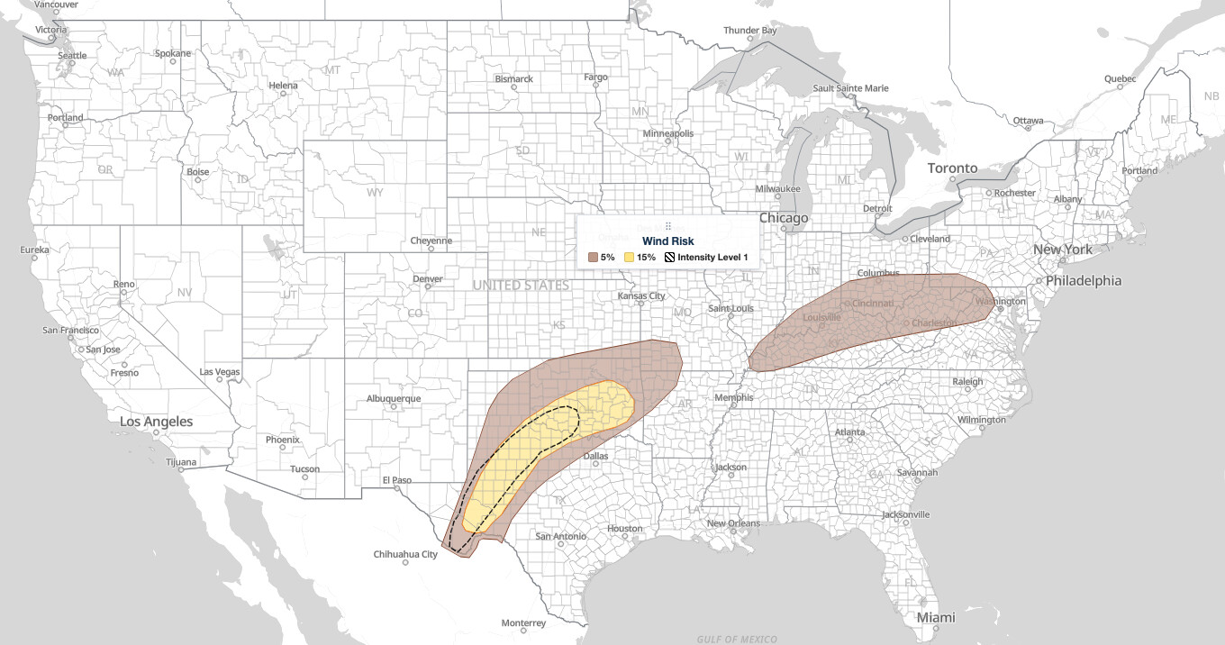
All six cities in the Southern Plains severe storms Slight Risk carry a 15% damaging wind probability from the SPC, meaning a 15% chance of a damaging wind report within 25 miles of a point. A 2% tornado probability is drawn over Oklahoma City, Wichita Falls, Lawton and Ardmore, covering 53,295 square miles and about 2.2 million people. Midland and Odessa are outside that tornado probability.
The large hail threat is focused farther southwest. SPC draws a 15% large hail probability over Midland, Odessa and Big Spring, an area of 18,405 square miles, with 5% extending to Amarillo, Lubbock, Abilene, San Angelo and Pampa in Texas. Oklahoma City, Wichita Falls, Lawton and Ardmore sit outside the 15% hail area even though they are in the Slight Risk.
Midland, Odessa, Wichita Falls and Lawton also fall inside SPC’s hatched Wind Conditional Intensity Level 1 area, shown as the dashed outline on the wind map below. It covers 43,919 square miles and about 870,000 people. Level 1 marks where storms that do turn severe could produce peak gusts above 75 mph; it is a conditional signal, not a forecast that those gusts will occur everywhere inside it.
Marginal Risk areas from Tulsa to the Big Bend and from the Ohio Valley to the Mid-Atlantic
A Marginal Risk area surrounds the Southern Plains severe storms Slight Risk, reaching Tulsa, Enid and Woodward in Oklahoma, Springfield and Joplin in Missouri, Fort Smith and Fayetteville in Arkansas, and Amarillo, Lubbock, Abilene, San Angelo and Pampa in Texas. Most of those cities carry a 5% damaging wind probability. Amarillo is the exception: it has a 5% large hail probability and no damaging wind probability drawn. A small separate Marginal area also sits along the Rio Grande in the Big Bend region, tied to a 5% hail probability.
Farther east, the second large Marginal Risk area runs from Columbus, Cincinnati and Dayton in Ohio through Louisville, Lexington, Bowling Green and Paducah in Kentucky, Evansville in Indiana, and Charleston, Morgantown and Elkins in West Virginia, reaching Cumberland and Hagerstown in Maryland and Winchester and Leesburg in Virginia. Every one of those cities carries a 5% damaging wind probability, with no hail or tornado probability drawn.
Outside the severe risk areas, Dallas, Fort Worth, Waco, Austin, San Antonio, Tyler, Wichita and Dodge City sit in the General Thunderstorms area, which marks non-severe storms.
Meteorologist’s take
The SPC discussion centers on a wavy outflow boundary that early morning surface observations and radar place from southern Illinois across southeast Missouri, northern Arkansas and eastern, central and southwest Oklahoma into the Texas South Plains. Showers and thunderstorms are ongoing north of that boundary, south of a primary cold front extending from the northern Texas Panhandle east-northeastward across northwest and north-central Oklahoma and on through southeast Kansas, central Missouri and northern Illinois. That front is forecast to stay stationary for much of the period.
Southerly low to mid-level flow persists through the day, and the associated warm-air advection across the outflow boundary will likely keep showers and thunderstorms going from the Texas Panhandle eastward across western and central Oklahoma. Where the outflow stops moving south is the key uncertainty. The SPC notes higher confidence over the southern High Plains, where the boundary has already lost much of its character and daytime heating should destabilize the airmass east of it, with temperatures possibly reaching the mid 80s amid mid to upper 60s dewpoints.
Across the southern High Plains, moderate buoyancy and effective shear of 40 to 50 knots support initial supercell structures capable of large hail and damaging gusts, with upscale growth into one or more linear bowing segments possible later. Once that happens, the primary threat transitions to and damaging gusts, with upscale growth into one or more linear bowing segments possible later. Once that happens, the primary threat transitions to damaging wind gusts. Farther north, from northwest Texas into east-central and southeast Oklahoma, the setup is more complex and uncertain, with the strongest buoyancy over south-central and southeast Oklahoma where mid 70s dewpoints remain.
The outflow is expected to retreat northward as an effective warm front later this afternoon and evening. A strengthening low-level jet supports a low-probability tornado risk with any more cellular warm sector development this evening, particularly from southwest into south-central Oklahoma where vertically veering wind profiles are anticipated. In the Ohio Valley, MLCAPE approaching 1000 to 1250 J/kg by mid to late afternoon, steepening low-level lapse rates and up to 35 to 40 knots of deep-layer shear appear supportive of isolated severe storms capable of damaging wind gusts into evening.
How to stay safe in Southern Plains severe storms
Damaging wind is the lead hazard for Southern Plains severe storms today, so plan around it. Move patio furniture and loose yard items indoors before afternoon storms arrive, and park vehicles away from large trees and weak carports. The National Weather Service defines a severe wind gust as 58 mph or greater, which is enough to down limbs and power lines.
Hail is the bigger concern in the Midland, Odessa and Big Spring area, where SPC draws the 15% probability. The NWS defines severe hail as one inch in diameter or larger. Keep vehicles under cover where possible and stay away from windows and skylights while a storm is overhead.
For the 2% tornado probability at Oklahoma City, Wichita Falls, Lawton and Ardmore, identify your safest room now: an interior space on the lowest floor, away from exterior walls. Mobile and manufactured homes are not safe in a tornado, so know where you will go before a warning is issued.
Because evening Southern Plains severe storms are expected, make sure you can be woken by a warning. Enable alerts on your phone and track cells with live radar and alerts from iAlert, and check your local weather forecast before heading out tonight.
Southern Plains severe storms FAQ
Where is the highest risk today?
The Slight Risk, level 2 of 5, covers Oklahoma City, Lawton and Ardmore in Oklahoma and Wichita Falls, Midland and Odessa in Texas. All six carry a 15% damaging wind probability from the SPC.
Is there a tornado risk?
Yes, a low one. A 2% tornado probability is drawn over Oklahoma City, Wichita Falls, Lawton and Ardmore. SPC describes a low-probability tornado risk this evening, particularly from southwest into south-central Oklahoma as a low-level jet strengthens.
When will storms arrive?
Thunderstorms with severe wind gusts are possible this afternoon and evening across parts of the southern Plains. Showers and storms are already ongoing, and additional storms are possible later this evening as linear clusters move east.
Does the Ohio Valley face the same threat?
No. The Ohio Valley and Mid-Atlantic sit in a Marginal Risk with a 5% damaging wind probability covering Columbus, Cincinnati, Dayton, Louisville, Lexington, Charleston, Hagerstown, Winchester and Leesburg. Isolated damaging wind gusts are the only hazard drawn there.
Watches and warnings can be issued quickly once storms mature, so keep a way to receive them through the afternoon and overnight. iAlert weather alerts and notifications will track the Southern Plains severe storms threat as the SPC updates its outlook.
Sources:
Get Severe Weather Alerts for Your Location
When any NWS watch, warning, or advisory is issued for your area, iAlert sends you an immediate notification by email, text message, or phone call, 24 hours a day, 7 days a week.
Sign Up for Severe Weather Alerts →

