
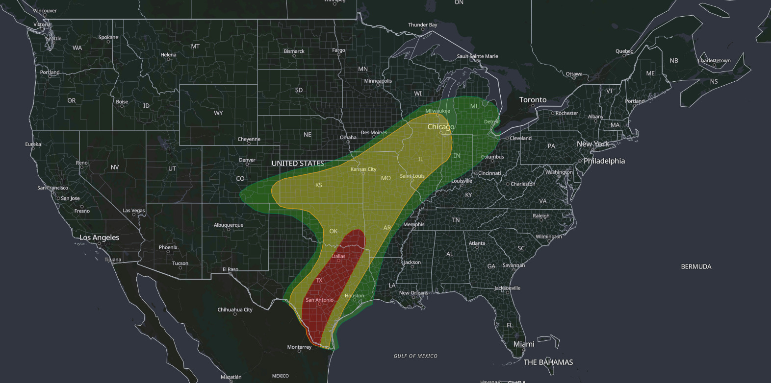
A Moderate Risk flash flood outlook covers south-central Texas from the Rio Grande Valley through San Antonio, Austin and the Dallas-Fort Worth Metroplex to southeast Oklahoma, according to the NOAA Weather Prediction Center Day 1 Excessive Rainfall Outlook issued at 4:25 am EDT Thursday, October 1, 2026. The outlook is valid from 7:00 am CDT Thursday to 7:00 am CDT Friday, October 2, and WPC calls for widespread rainfall of 3 inches or more along the I-35 corridor, with hourly rates of 1–2 inches.
Key points:
- Highest category: Moderate Risk, Level 3 of 4, from South Texas to southeast Oklahoma.
- Places inside the Moderate Risk: San Antonio, Austin, Dallas-Fort Worth, the Texas Hill Country and Deep South Texas.
- Rainfall: widespread 3 inches or more, 2–4 inches in the Hill Country, over 5 inches possible south of San Antonio.
- Valid window: 7:00 am CDT Thursday, October 1, to 7:00 am CDT Friday, October 2, 2026.
- A Slight Risk extends from Texas through Kansas, Missouri and Illinois to southern Wisconsin and Indiana.
Get Severe Weather Alerts for Your Location
When any NWS watch, warning, or advisory is issued for your area, iAlert sends you an immediate notification by email, text message, or phone call, 24 hours a day, 7 days a week.
Sign Up for Severe Weather Alerts →Where the Moderate Risk flash flood threat is highest
WPC forecasters point to “much of the more flash flood prone areas of south-central Texas, including the I-35 corridor from Dallas-Fort Worth to Austin-San Antonio,” with a second rainfall maximum in the southern Rio Grande Valley. They placed the Moderate Risk from South Texas to southeast Oklahoma.
The Texas Hill Country is the area of greatest concern. WPC calls it “the most notable area for appreciable impacts,” with another round of 2–4 inches and locally higher totals over terrain that is sensitive to flash flooding. Thin soils and steep, rock-lined creek valleys move runoff into rivers fast, the same setup behind the deadly Guadalupe River flood of July 4, 2025.
Farther south, WPC puts the odds of more than 5 inches at 60 to 90 percent across a large area from just south of San Antonio into the Rio Grande Valley.
Why rain will keep falling on the same areas
A slow-moving cold front is the driver. WPC notes that the front “will be slow to progress through the state,” so the zone of converging winds along and just ahead of it stays in place for hours. That creates an extended period for training, where storms form and move over the same towns one after another, like train cars over a single track.
Rain rates are the other problem. WPC expects hourly rates of 1–2 inches, with bursts of 3–4 inches per hour inside the heaviest cells, a signature the forecasters describe as “notorious for elevated flash flood concerns within the Hill Country and the I-35 corridor.”
The Slight Risk farther north has a tropical source. Moisture tied to the remnants of Tropical Cyclone Polo is spreading over the Plains and Midwest, where precipitable water values (the total moisture in a column of air) of 2 to 2.25 inches run 3 to 4 standard deviations above normal for early October, near daily and even monthly records for the area.
What a Moderate Risk flash flood outlook means
The Excessive Rainfall Outlook, or ERO, is the Weather Prediction Center’s probabilistic forecast of where rainfall is likely to exceed flash flood guidance, the amount of rain an area can absorb before small streams and urban drainage begin to fail. It is the primary federal flash flood outlook and feeds directly into local National Weather Service watch decisions.
WPC uses four tiers. Marginal corresponds to at least a 5 percent chance that rainfall exceeds flash flood guidance within 25 miles of a point, Slight to at least 15 percent, Moderate to at least 40 percent, and High to at least 70 percent. A Moderate Risk flash flood designation sits one step below the top tier.
Forecasters do not reach for this category casually. Moderate Risk days are a minority of the year, and High Risk days number only a handful, so a Moderate Risk signals an above-average combination of rainfall rates, slow storm motion and vulnerable ground.
Timing: a 24-hour window with a dangerous night
This outlook covers the full 24 hours from 7:00 am CDT Thursday to 7:00 am CDT Friday. Rain will not fall everywhere the whole time, but with a stalled front, the heaviest bands can linger or redevelop after dark.
Thursday night is the most dangerous stretch. Drivers cannot judge water depth across a dark road, residents in low-lying homes are asleep, and the visual signs that a creek has left its banks are hidden until headlights are already in the water.
Meteorologist’s take
The ERO answers a narrower question than most people assume. It does not forecast how much rain falls. It forecasts the odds that whatever falls exceeds what the ground, the streams and the storm sewers in that location can handle, which is why two places with identical rainfall can sit in different risk categories.
That is why this setup stands out. Rates of 1–2 inches per hour along the I-35 corridor run straight into the heavy pavement of San Antonio, Austin and Dallas-Fort Worth, and into the fast-draining creeks of the Hill Country. Both have low flash flood thresholds.
The outlook cannot tell you which neighborhood floods. The ERO works at a regional scale measured in tens of miles, while flash flooding turns on culvert capacity, terrain and where one training line of storms sets up. For that detail you need warnings from your local NWS office and live radar and alerts.
Treat the outlook as the opening bid. WPC reissues the Day 1 ERO during the day, and local offices refine it with flash flood watches and, when water is rising, warnings.
How to stay safe in a Moderate Risk flash flood
This guidance applies to the hazard in this outlook: rapidly rising water from repeated heavy rain, with the worst of it possible after dark.
- Turn Around, Don’t Drown. Most US flood deaths happen in vehicles, and 12 inches of moving water can carry away most cars.
- Never drive around barricades on a closed road. The pavement underneath may already be gone.
- Turn on Wireless Emergency Alerts and leave your phone volume up overnight so a warning can wake you.
- If you sleep in a basement or ground-floor unit in a flood-prone area, decide now where you would move upstairs.
- Campers along Hill Country rivers and anyone staying near a creek or low-water crossing should move to higher ground before dark, not after water rises.
If you live inside the Moderate Risk area, know your own flood history: whether your street holds water, whether your home has taken water before, and which route out of your neighborhood stays high. Check your local weather forecast and active weather alerts before you go to bed.
The single most dangerous decision tonight is driving. Low-water crossings are common across the Hill Country and the I-35 suburbs, and water that looks shallow under headlights can hide a washed-out roadbed. If water covers the road, turn around and find another way.
This Moderate Risk flash flood outlook runs through 7:00 am CDT Friday, October 2, 2026. Local flash flood watches and warnings always supersede it, so follow your NWS office and iAlert weather alerts and notifications through Thursday night.
Moderate Risk flash flood FAQ
Where is the highest flood risk on October 1, 2026?
The Moderate Risk covers south-central Texas from the Rio Grande Valley through San Antonio, Austin and Dallas-Fort Worth to southeast Oklahoma. WPC singles out the Texas Hill Country as the area most likely to see serious impacts.
How much rain is expected in Texas?
WPC expects widespread totals of 3 inches or more along the I-35 corridor, 2–4 inches with locally higher amounts in the Hill Country, and a 60 to 90 percent chance of more than 5 inches from south of San Antonio into the Rio Grande Valley.
How serious is a Level 3 of 4 risk?
Moderate Risk is the second-highest of WPC’s four tiers, below only High Risk. It means at least a 40 percent chance that rainfall exceeds local flash flood guidance within 25 miles of a point.
When does this outlook start and end?
It is valid from 12Z Thursday, October 1, 2026, which is 7:00 am CDT and 8:00 am EDT, through 12Z Friday, October 2, which is 7:00 am CDT and 8:00 am EDT.
What is the difference between a flash flood watch and a warning?
A watch means conditions favor flash flooding in the coming hours. A warning means flooding is imminent or already happening. An outlook like this one comes before either and covers a broader area.
Sources:
- NOAA Weather Prediction Center, Day 1 Excessive Rainfall Outlook and Discussion, issued 4:25 am EDT October 1, 2026
- NOAA Weather Prediction Center, Excessive Rainfall Outlook product description
Get Severe Weather Alerts for Your Location
When any NWS watch, warning, or advisory is issued for your area, iAlert sends you an immediate notification by email, text message, or phone call, 24 hours a day, 7 days a week.
Sign Up for Severe Weather Alerts →

