
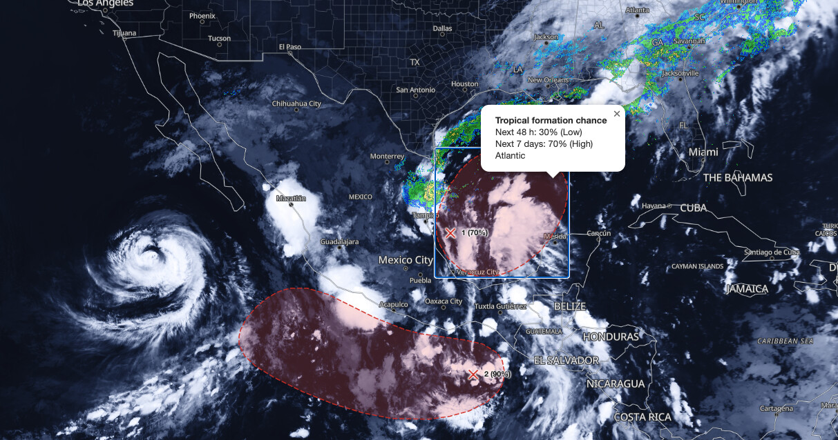
Gulf tropical development is now considered likely by the National Hurricane Center, which raised the seven-day formation chance for a disturbance in the southwestern Gulf to 70 percent in its 8 AM EDT outlook on Monday, October 5, 2026. A trough of low pressure in the southwestern Gulf is producing disorganized showers and thunderstorms, and NHC forecasters say a tropical depression is likely to form during the middle or latter portion of the week.
Key points:
- NHC gives the disturbance a 70% formation chance through seven days.
- Two-day odds sit at 30%, up from near 0% on Sunday.
- A trough of low pressure has formed along the coast of Mexico in the southwestern Gulf.
- NHC expects it to drift eastward for a few days, then turn northward.
- A tropical depression is likely mid to late week.
Get Severe Weather Alerts for Your Location
When any NWS watch, warning, or advisory is issued for your area, iAlert sends you an immediate notification by email, text message, or phone call, 24 hours a day, 7 days a week.
Sign Up for Severe Weather Alerts →What the National Hurricane Center says about Gulf tropical development
The Monday morning Tropical Weather Outlook from NHC in Miami describes a trough of low pressure in the southwestern Gulf that is already generating disorganized showers and thunderstorms. Forecaster Kelly wrote that environmental conditions appear to be marginally conducive, but that gradual development is becoming more likely. It is the first outlook in this sequence to call Gulf tropical development likely rather than possible.
NHC says a tropical depression is likely to form during the middle or latter portion of the week. The system is expected to drift eastward over the next few days before it turns northward.
Formation odds as of 8 AM EDT Monday stand at 30 percent through 48 hours and 70 percent through seven days. That 70 percent figure moves the disturbance into the high category on the NHC scale, which covers formation chances greater than 60 percent.
How the Gulf tropical development odds climbed since Saturday
The rise in confidence has been steady rather than abrupt. At 8 PM EDT Saturday, October 3, Forecaster Blake said a broad area of low pressure could form in a few days, with a 20 percent seven-day chance. By 2 AM Sunday, Forecaster Beven raised that to 30 percent, and the 8 AM Sunday outlook held 30 percent while adding that the system would drift northward.
At 2 PM EDT Sunday, NHC said a low was likely to form around the middle of the week and lifted the seven-day odds to 40 percent, a figure the 8 PM Sunday outlook held. Forecaster Papin’s 2 AM Monday outlook then confirmed that a surface trough had developed along the coast of Mexico, raised the seven-day chance to 50 percent, nudged the 48-hour odds to 10 percent, and introduced the eastward drift before a northward turn.
That progression matters more than any single number. Seven consecutive outlooks moved the seven-day odds for Gulf tropical development from 20 to 70 percent without a single step backward, and each one added detail as the surface feature became real rather than modeled.
| Outlook (EDT) | Forecaster | 48-hour chance | 7-day chance |
|---|---|---|---|
| 8 PM Sat Oct 3 | Blake | Near 0% | 20% |
| 2 AM Sun Oct 4 | Beven | Near 0% | 30% |
| 8 AM Sun Oct 4 | Cangialosi | Near 0% | 30% |
| 2 PM Sun Oct 4 | Cangialosi | Near 0% | 40% |
| 8 PM Sun Oct 4 | Pasch | Near 0% | 40% |
| 2 AM Mon Oct 5 | Papin | 10% | 50% |
| 8 AM Mon Oct 5 | Kelly | 30% | 70% |
Meteorologist’s take on Gulf tropical development
Two details in the NHC text deserve attention. The first is the phrase “marginally conducive,” which NHC has used in every outlook since Sunday afternoon. That is forecaster language for an environment that allows organization but does not favor quick development, and it fits the gradual development NHC describes rather than a rapid spin-up.
The second is the motion. NHC expects the system to drift eastward over the next few days before turning northward. A slow-moving disturbance spends a long time over the same water and can produce heavy rain over the same areas for days, which is why slow Gulf systems can matter to land even when their winds stay modest.
As general context, not a forecast for this system, tropical depressions and weak tropical storms in the Gulf are often remembered for rainfall and flooding rather than wind. Wind categories describe the circulation, not the water the circulation carries. That is why the track and timing of Gulf tropical development are worth following even while the intensity outlook stays modest.
One more point: a 70 percent chance of formation is not a 70 percent chance of a United States landfall. NHC’s formation probability answers only whether a tropical depression or storm will form, and no NHC product cited here specifies where this system ends up. Treat the current Gulf tropical development signal as a reason to pay attention, not a reason to assume an outcome.
NHC is also tracking a separate disturbance in the eastern Pacific, south of southern Mexico, with a 90 percent seven-day formation chance as of 5 AM PDT Monday. That system is forecast to move west-northwestward to northwestward just offshore of the southern to southwestern coast of Mexico, away from the Gulf.
How to stay safe during Gulf tropical development
There are no coastal watches or warnings tied to this disturbance in the outlooks cited here, so the right action this early is preparation and monitoring rather than response. Residents and visitors along the Gulf coast should use the quiet part of the week to review hurricane plans and supplies while the Gulf tropical development forecast comes into focus.
Check the NHC Tropical Weather Outlook at least twice a day. The outlooks are issued every six hours, at 2 AM, 8 AM, 2 PM, and 8 PM EDT, and this weekend showed how much a single cycle can change. You can follow the system on the iAlert hurricane tracker and check your local weather forecast for day-to-day conditions.
Confirm now that you can receive official warnings overnight. NHC advisory packages, and any watches or warnings issued with them, come out at 11 PM and 5 AM EDT as well as during the day. Enable push alerts, keep a charged phone, and know which county or parish you live in, because active weather alerts are issued by county name rather than by city.
Because the practical risk will depend on a track that does not exist yet, avoid acting on single model runs shared on social media. Use the NHC outlook and your local National Weather Service office as the baseline, and wait for an advisory package before making travel or evacuation decisions.
Gulf tropical development FAQ
Where is the disturbance located?
The system is a trough of low pressure in the southwestern Gulf, along the coast of Mexico. NHC’s 2 AM EDT Monday outlook was the first to confirm that a surface trough had actually developed there.
What are the chances a tropical depression forms?
NHC gives a 70 percent chance of formation through seven days and 30 percent through 48 hours as of 8 AM EDT Monday, October 5, 2026. The seven-day odds were 20 percent on Saturday evening.
When could a tropical depression form?
NHC says a tropical depression is likely to form during the middle or latter portion of the week. Sunday’s outlooks pointed to late in the week, so the expected timing has moved slightly earlier.
Which way is the system expected to move?
NHC expects the disturbance to drift eastward over the next few days before turning northward. The outlooks cited here do not identify a specific destination, and no coastal watches or warnings are tied to this Gulf tropical development.
Sources:
- NOAA/NWS National Hurricane Center, Atlantic Tropical Weather Outlook, 8 AM EDT Mon Oct 5, 2026 (Forecaster Kelly)
- NOAA/NWS National Hurricane Center, Atlantic Tropical Weather Outlook, 2 AM EDT Mon Oct 5, 2026 (Forecaster Papin)
- NOAA/NWS National Hurricane Center, Atlantic Tropical Weather Outlook, 8 PM EDT Sun Oct 4, 2026 (Forecaster Pasch)
- NOAA/NWS National Hurricane Center, Atlantic Tropical Weather Outlook, 2 PM EDT Sun Oct 4, 2026 (Forecaster Cangialosi)
- NOAA/NWS National Hurricane Center, Atlantic Tropical Weather Outlook, 8 AM EDT Sun Oct 4, 2026 (Forecaster Cangialosi)
- NOAA/NWS National Hurricane Center, Atlantic Tropical Weather Outlook, 2 AM EDT Sun Oct 4, 2026 (Forecaster Beven)
- NOAA/NWS National Hurricane Center, Atlantic Tropical Weather Outlook, 8 PM EDT Sat Oct 3, 2026 (Forecaster Blake)
- NOAA/NWS National Hurricane Center, Eastern Pacific Tropical Weather Outlook, 5 AM PDT Mon Oct 5, 2026 (Forecaster Kelly)
Get Severe Weather Alerts for Your Location
When any NWS watch, warning, or advisory is issued for your area, iAlert sends you an immediate notification by email, text message, or phone call, 24 hours a day, 7 days a week.
Sign Up for Severe Weather Alerts →


Pingback: Hurricane Isaias Landfall: 110 mph Winds, 9 ft Surge