
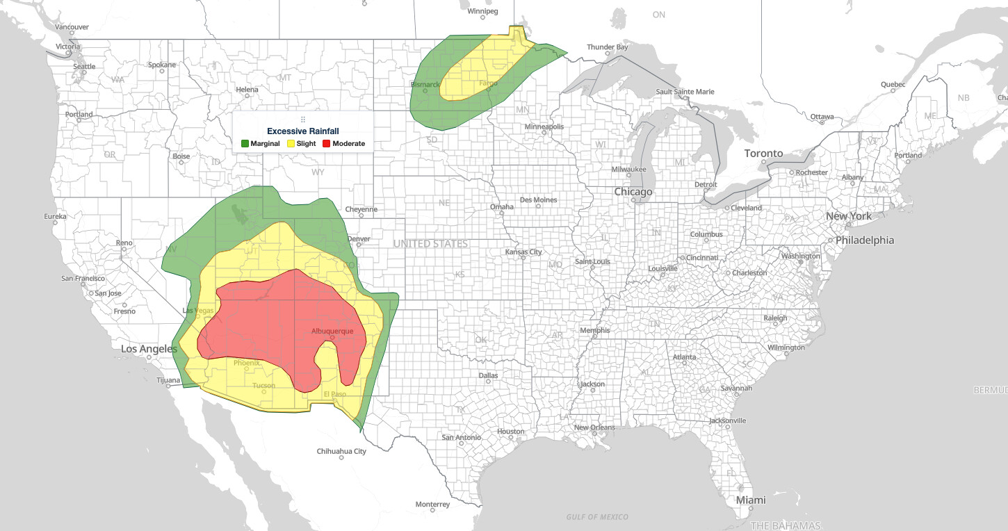
Moderate Risk flash flooding covers much of the Four Corners region under the NOAA Weather Prediction Center’s Day 1 Excessive Rainfall Outlook for Monday, September 28, 2026. The outlook is valid through 6:00 am MDT (5:00 am MST in Arizona) Tuesday, September 29. Moderate is level 3 of 4 on the WPC scale, and forecasters expect a widespread 1–3 inches of rain on soils that are already at or near saturation from recent heavy rainfall.
Key points:
- Moderate Risk (level 3 of 4): northern and eastern Arizona, southern Utah, southwest Colorado, and much of New Mexico, including Albuquerque.
- The 16Z update extended the Moderate Risk down the Colorado River to the California, Arizona, and Nevada tripoint.
- Cause: a predecessor rain event fed by moisture from Odalys and the approach of Tropical Cyclone Polo.
- A separate Slight Risk (level 2 of 4) covers eastern North Dakota and northwest Minnesota, where training storms are already underway.
- WPC keeps a Moderate Risk over the Southwest and southern High Plains on Tuesday and Wednesday.
Get Severe Weather Alerts for Your Location
When any NWS watch, warning, or advisory is issued for your area, iAlert sends you an immediate notification by email, text message, or phone call, 24 hours a day, 7 days a week.
Sign Up for Severe Weather Alerts →Where the Moderate Risk flash flooding is outlined
The Moderate Risk area is a broad oval centered on the Four Corners. It runs from the Colorado River near the California, Arizona, and Nevada tripoint east across northern Arizona and southern Utah into southwest Colorado and New Mexico. In New Mexico it forks south to include the Lordsburg area and the Sacramento Mountains, two places WPC singles out for their burn scars.
WPC names the terrain most likely to see the heaviest totals: the south- and west-facing slopes of the Mogollon Rim in Arizona and the San Juan Mountains of Colorado, both of which sit square to the southwest flow. Southern Utah is flagged for its slot canyons and burn scars, and much of New Mexico for saturated ground.
Phoenix, Tucson, El Paso, and Las Vegas sit just outside the Moderate area in the surrounding Slight Risk (level 2 of 4). A Marginal Risk (level 1 of 4) rims the whole region from southern Nevada to eastern Colorado. With this update WPC also pushed the Marginal and Slight areas north along the Nevada and Utah border, where morning showers could organize into nearly stationary lines by afternoon.
What is driving the Southwest flood threat
WPC describes the setup as a predecessor rainfall event (PRE), a band of heavy rain that forms well ahead of a tropical system along a plume of its moisture. Here the plume comes from the combination of Odalys and the approaching Tropical Cyclone Polo. Precipitable water, the total moisture in the air column, is running 2 to 3.5 standard deviations above normal across much of the region.
Strong upper-level divergence and southwest flow striking the terrain head-on add lift from both the large-scale pattern and the mountains. That combination is what turns a moist airmass into repeated heavy rain over the same slopes.
One mitigating factor: WPC’s 16Z discussion notes that much of the rain falling in Arizona Monday morning is steady stratiform rain rather than intense thunderstorms, because instability is limited. WPC calls the day “on the low end of the MDT risk category,” but kept the Moderate Risk in place because of the moisture levels and flash-flood-prone ground. It expects a small cluster or line of slow-moving storms to develop near the Colorado River this afternoon as skies clear and heating builds.
What a Moderate Risk flash flooding outlook means
The Excessive Rainfall Outlook, or ERO, is WPC’s national flash flood forecast. It gives the probability that rainfall will exceed flash flood guidance, the amount of rain an area can absorb before small streams and drainage systems overflow.
A Moderate Risk flash flooding outlook means at least a 40 percent chance that flash flood guidance is exceeded within about 25 miles of any point in the outlined area. Slight corresponds to at least 15 percent and Marginal to at least 5 percent. Only the High Risk, level 4 of 4, ranks above Moderate.
It is a statement of likelihood, not a report that flooding is underway. Flash Flood Warnings from local National Weather Service offices identify the specific communities at immediate risk.
Moderate Risk flash flooding timing: 6 am MDT Monday to 6 am MDT Tuesday
The Day 1 outlook covers 12Z Monday to 12Z Tuesday. In local time that is 6:00 am MDT in New Mexico, Colorado, and Utah, 5:00 am MST in Arizona, 5:00 am PDT in southern Nevada and California, and 7:00 am CDT in North Dakota and Minnesota.
Afternoon heating is the main trigger for the slow-moving storms WPC expects near the Colorado River, but steady rain on saturated soil can keep streams rising well into the night. For current warnings, check the live radar and alerts page and the list of active weather alerts, both updated continuously.
Slight Risk in North Dakota and northwest Minnesota
A second outlook area covers the northern Plains. Upper-level jet forcing and deepening moisture, with precipitable water near 1.5 inches, are feeding training showers and storms across eastern North Dakota into northwest Minnesota. Training means cells repeatedly crossing the same ground.
The Slight Risk includes Fargo and Grand Forks and was expanded southwest toward southern North Dakota. WPC made no changes at 16Z because the event is already ongoing. Bismarck is in the surrounding Marginal Risk, which extends from northern South Dakota across North Dakota to far northwest Minnesota.
Meteorologist’s take
This Moderate Risk flash flooding day is a textbook late-season Southwest flood setup. Tropical moisture arriving after recent heavy rain finds ground that cannot absorb more water, and flash flood guidance values drop to fractions of an inch. The steady rain in Arizona this morning is the good news; the saturated soils mean it does not take thunderstorm rainfall rates to cause problems.
The terrain is the multiplier. A slot canyon can flood from a storm that never reaches the hikers inside it, and a burn scar can send debris flows downhill from as little as half an inch of rain in an hour. WPC singles out the Lordsburg area, the Sacramento Mountains, southern Utah’s canyons, and the San Juans for exactly these reasons.
This is also the first day of a multi-day event, not a one-day spike. WPC’s Day 2 outlook keeps a Moderate Risk from south-central Arizona to the Texas Panhandle and western Kansas on Tuesday as Polo’s remnant energy is absorbed into an upper trough, and the Day 3 outlook holds Moderate Risks over the central and southern High Plains on Wednesday. Track Polo on the iAlert hurricane tracker.
How to stay safe during Moderate Risk flash flooding
More than half of flood drownings in the United States happen when a vehicle is driven into flood water, often on roads that looked passable. During Moderate Risk flash flooding in the desert Southwest, dry washes and low-water crossings can go from empty to impassable in minutes.
More than half of flood drownings in the United States happen when a vehicle is driven into flood water, often on roads that looked passable. During Moderate Risk flash flooding in the desert Southwest, dry washes and low-water crossings can go from empty to impassable in minutes.
- Never drive into water covering a roadway. Turn around and find another route.
- Avoid slot canyons, dry washes, and canyon hikes through Tuesday, even under clear skies.
- If you live below a burn scar, know your evacuation route and leave at the first sign of a debris flow.
- Move to higher ground immediately if water rises near your home or campsite.
- Do not walk through moving water; six inches can knock an adult down.
- Keep phones charged and alerts audible overnight, and enable a second alerting method.
You can check conditions for your area on the local weather forecast page. WPC’s four-tier rainfall scale follows the same logic as the Storm Prediction Center’s five-tier severe storm scale, explained in our guide to SPC outlook risk categories.
Moderate Risk flash flooding FAQ
Where is the Moderate Risk flash flooding area?
Across the Four Corners: northern and eastern Arizona, southern Utah, southwest Colorado, and much of New Mexico, including Albuquerque, Lordsburg, and the Sacramento Mountains. It extends west along the Colorado River to the California, Arizona, and Nevada tripoint.
What does a Moderate Risk mean on the Excessive Rainfall Outlook?
Level 3 of 4, the second-highest WPC category. It means at least a 40 percent chance that rainfall exceeds flash flood guidance within about 25 miles of any point in the outlined area.
Why is the Southwest flooding in late September?
WPC attributes the rain to a predecessor rainfall event fed by moisture from Odalys and the approach of Tropical Cyclone Polo. Moisture levels are 2 to 3.5 standard deviations above normal, and soils are already saturated from recent heavy rain.
When does this outlook expire?
The Day 1 outlook runs through 6:00 am MDT (5:00 am MST in Arizona) Tuesday, September 29, 2026. WPC’s Day 2 outlook keeps a Moderate Risk over the Southwest and southern High Plains through Wednesday morning.
Does a Moderate Risk mean flooding is guaranteed?
No. Moderate Risk flash flooding is a probability, not a certainty, and most of the outlined area will not flood. Flash Flood Warnings issued during the event identify the specific communities at immediate risk.
Sources:
- NOAA Weather Prediction Center, Excessive Rainfall Outlook
- NOAA Weather Prediction Center, Excessive Rainfall Discussion, 11:33 am EDT September 28, 2026
Get Severe Weather Alerts for Your Location
When any NWS watch, warning, or advisory is issued for your area, iAlert sends you an immediate notification by email, text message, or phone call, 24 hours a day, 7 days a week.
Sign Up for Severe Weather Alerts →

