
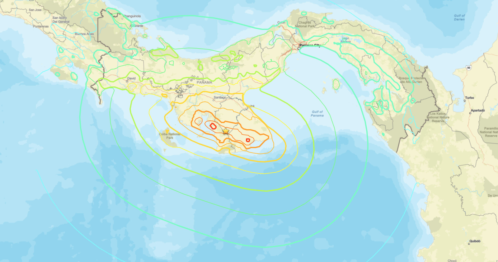
A powerful Panama earthquake struck the Azuero Peninsula on Friday, October 9, 2026, when a magnitude 7.7 quake hit 12 kilometers west-southwest of Pitaloza Arriba at 12:56 p.m. local time (17:56:06 UTC). The U.S. Geological Survey places the hypocenter just 12.6 kilometers deep, has issued a RED PAGER alert, and estimates that roughly 4.6 million people experienced Moderate (MMI V) to Severe (MMI VIII) shaking.
Key points:
- Magnitude 7.7, 12.6 km deep, near Pitaloza Arriba, Panama.
- Occurred Friday, Oct 9, 2026, 12:56 p.m. local time (17:56 UTC).
- USGS PAGER: RED for economic losses, YELLOW for fatalities (some casualties possible).
- About 4.6 million people felt MMI V to VIII shaking; about 3,700 near the source felt MMI IX.
- Aftershocks, some with strong shaking, may follow the Panama earthquake.
What the USGS reported about the Panama earthquake
The USGS National Earthquake Information Center lists the Panama earthquake at magnitude 7.7 mww with a reviewed origin, centered at 7.587°N, 80.769°W. Its PAGER assessment issued a red alert for economic losses, stating that extensive damage is probable and the disaster is likely widespread, and noting that past events at this level have required a national or international response. The separate fatality estimate is yellow: some casualties are possible.
PAGER estimates Severe (MMI VIII) shaking in Tonosí and Very Strong (MMI VII) shaking in Macaracas, Pedasí, Las Tablas, Santiago, and Chitré. The shaking also reached into Costa Rica, where about 206,000 people are estimated to have felt Moderate (MMI V) intensity.
Citizen science responses added an on-the-ground picture quickly. “Did You Feel It?” submissions produced a maximum community intensity of IX, and the modeled ShakeMap also shows a maximum estimated intensity of IX near the source region.
USGS ground failure products for the Panama earthquake estimate a significant area affected by landsliding with limited population exposed, plus a significant area and significant population exposed to liquefaction. The USGS also notes that aftershocks, some potentially producing strong shaking, may follow.
Tectonic setting behind the Panama earthquake
Panama sits near the junction of several major tectonic plates: the oceanic Cocos and Nazca plates to the west and south, and the Caribbean and South America plates to the north and east. Those larger plates surround the Panama microplate.
Along the southern boundary, the Cocos plate subducts beneath the Panama microplate and the Nazca plate obliquely converges with the microplate, while the Caribbean plate subducts beneath the microplate along the northern boundary. According to the USGS, the focal mechanism of the Panama earthquake indicates left-lateral strike-slip faulting, consistent with the style of deformation commonly observed along this complex plate boundary.
Earthquakes are frequent in this region, though most historical seismicity has been concentrated west of this event along the Panama Fracture Zone, the north-south boundary separating the Cocos and Nazca plates. The USGS cites a magnitude 7.5 event in July 1934 and a magnitude 7.2 event in July 1962 in the broader area.
Meteorologist’s take
Depth is the number that matters most here. A 12.6 kilometer hypocenter is shallow, so a large share of the released energy reaches the surface close to the epicenter instead of spreading out through the crust. That is why the estimated intensities for the Panama earthquake run as high as MMI IX rather than being blunted by distance.
IX rather than being blunted by distance.Strike-slip faulting moves blocks of crust mostly horizontally, so it typically displaces less water vertically than a comparable thrust-fault rupture, the geometry that most efficiently generates large ocean-wide tsunamis. That is a tendency, not a guarantee, and local effects can still matter. The USGS directs the public to tsunami.gov for official tsunami alert information.
The weather connection is indirect but real. Strong shaking loosens soil and rock on steep terrain, and heavy rain on those destabilized slopes raises landslide and debris flow risk for weeks afterward. Communities within the landslide and liquefaction areas flagged by the USGS should treat heavy rain as an added hazard during recovery.
How to stay safe after the Panama earthquake
On the coast, follow instructions from local authorities and check official tsunami messaging at tsunami.gov rather than relying on social media. If you are near the shore and feel long or violent shaking, move inland and to higher ground without waiting for an official message.
Stay out of damaged buildings until they are inspected, avoid steep slopes and cut banks where ground failure is possible, and report what you felt through the USGS “Did You Feel It?” survey, which sharpens intensity mapping. US readers can keep an eye on hazards closer to home with active weather alerts from iAlert.
Panama earthquake FAQ
How strong was the quake?
Magnitude 7.7 (mww), at a depth of 12.6 kilometers, centered 12 kilometers west-southwest of Pitaloza Arriba, Panama. The USGS lists the origin as reviewed.
When did it happen?
The quake occurred on Friday, October 9, 2026, at 17:56:06 UTC, which was 12:56 p.m. local time in Panama.
How many people felt the shaking?
About 4.6 million people experienced Moderate (MMI V) to Severe (MMI VIII) shaking, according to the USGS. Both the ShakeMap and “Did You Feel It?” products show a maximum intensity of IX near the source.
Is a tsunami expected?
The USGS points the public to tsunami.gov for tsunami alert information on this event. Check that site and local officials for the current status rather than assuming any outcome.
Will there be aftershocks?
Yes, the USGS says aftershocks may follow, some potentially with strong shaking. Treat damaged structures as unsafe until inspected.
Sources:
- USGS: M 7.7, 12 km WSW of Pitaloza Arriba, Panama
- USGS PAGER: Estimated impacts and population exposure
- NOAA Tsunami Warning System (tsunami.gov)
Get Severe Weather Alerts for Your Location
When any NWS watch, warning, or advisory is issued for your area, iAlert sends you an immediate notification by email, text message, or phone call, 24 hours a day, 7 days a week.
Sign Up for Severe Weather Alerts →

