
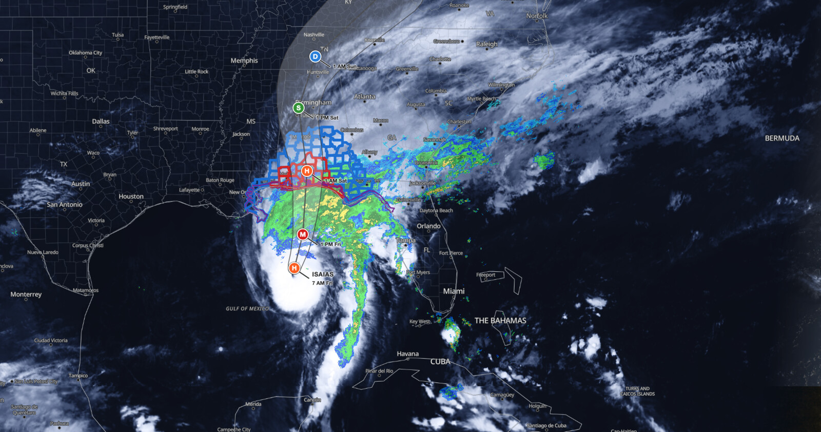
Hurricane Isaias landfall is expected tonight or early Saturday along the northern Gulf Coast, with the National Hurricane Center placing the center about 245 miles south of Pensacola, Florida at 7 AM CDT Friday, October 9, 2026, and maximum sustained winds near 110 mph. A Storm Surge Warning is in effect from the Mouth of the Mississippi River to the Suwannee River, Florida, where peak inundation of 6 to 9 feet above ground is possible from the Alabama/Florida border to Grayton Beach, Florida.
Key points:
- Category 2 hurricane, 110 mph winds, 958 mb central pressure at 7 AM CDT Friday.
- Hurricane Isaias landfall expected Friday night or early Saturday inside the Hurricane Warning area.
- Life-threatening storm surge of 6 to 9 feet possible from the Alabama/Florida border to Grayton Beach.
- Rain of 4 to 8 inches, locally 15 inches, across southern Alabama and the Panhandle.
- NHC says preparations should be completed within the next few hours.
Get Severe Weather Alerts for Your Location
When any NWS watch, warning, or advisory is issued for your area, iAlert sends you an immediate notification by email, text message, or phone call, 24 hours a day, 7 days a week.
Sign Up for Severe Weather Alerts →Where Hurricane Isaias landfall is expected
At 7 AM CDT Friday, the center was near latitude 27.0 North, longitude 87.7 West, about 245 miles south of Pensacola, Florida and about 170 miles south-southeast of the Mouth of the Mississippi River. The storm was moving north-northeast near 15 mph, and a turn toward the north is expected later today. On that track, Isaias approaches the northern Gulf Coast this afternoon.
The coastline framing Hurricane Isaias landfall sits inside a Hurricane Warning that runs from Ocean Springs, Mississippi to the Bay/Gulf County line in Florida. Tropical Storm Warnings extend west to the Jefferson/Plaquemines Parish line in Louisiana and east from the Bay/Gulf County line to the Aucilla River in Florida.
The Storm Surge Warning stretches from the Mouth of the Mississippi River to the Suwannee River, with a Storm Surge Watch from the Suwannee River to Yankeetown, Florida. Air Force Reserve Hurricane Hunter data supported the 110 mph intensity ahead of Hurricane Isaias landfall, and a reconnaissance dropsonde measured the minimum central pressure at 958 mb (28.29 inches). Isaias grew from the southwestern Gulf disturbance iAlert covered in the Gulf tropical development outlook earlier this week.
Hazards and warnings ahead of Hurricane Isaias landfall
Storm surge is the headline threat of Hurricane Isaias landfall. The NHC lists peak inundation of 6 to 9 feet from the Alabama/Florida border to Grayton Beach, 4 to 7 feet from Grayton Beach to Indian Pass, 4 to 6 feet from Dauphin Island, Alabama to the Alabama/Florida border, and 4 to 6 feet from Indian Pass to the Steinhatchee River.
Farther along the coast, 3 to 5 feet is possible from the Steinhatchee River to the Suwannee River, from the Mouth of the Mississippi River to Dauphin Island, and in Mobile Bay, with 2 to 4 feet from the Suwannee River to Yankeetown. The deepest water during Hurricane Isaias landfall occurs along the immediate coast where winds blow onshore, accompanied by large and dangerous waves.
Rainfall is the second major hazard in the days around Hurricane Isaias landfall. Through the weekend, the NHC expects 4 to 8 inches across southern Alabama, the Florida Panhandle and Big Bend, and southwest Georgia, with localized totals to 15 inches in banding over the Panhandle and Big Bend. Much of the rest of the Southeast can expect 2 to 5 inches, locally up to 10 inches over the Southern Appalachians and coastal Carolinas.
Hurricane-force winds extend outward up to 30 miles from the center and tropical-storm-force winds up to 185 miles. In the 4 AM CDT forecast/advisory, tropical-storm-force winds reached farthest in the northwest at about 185 miles and the northeast at about 175 miles, and only about 80 miles in the southwest. Hurricane-force winds reached about 30 miles in the northeast and southeast quadrants and about 17 miles in the southwest.
A tornado risk begins late this afternoon and continues tonight in coastal Alabama, the Florida Panhandle and far southwest Georgia, then shifts Saturday to parts of eastern Alabama, the Florida Panhandle, Georgia and the Carolinas. The NOAA Storm Prediction Center has a Slight Risk in place for the Panhandle today, covered in our Florida Panhandle tornado risk outlook. Swells from Isaias will also spread toward the Gulf Coast later today, bringing life-threatening surf and rip currents.
Forecast track and intensity into Hurricane Isaias landfall
The NHC forecast brings Isaias to a peak intensity of 120 mph at 1 PM CDT Friday, October 9, which would make it a major hurricane, before a weakening trend begins near the coast. The agency says Isaias is likely to become a major hurricane this morning and to remain a dangerous hurricane at landfall this evening or tonight.
The track carries the center inland as a 75 mph Category 1 hurricane by 1 AM CDT Saturday, October 10, and to post-tropical status by 1 PM CDT Saturday over west-central Alabama. The last forecast point with tropical-storm-force winds is 1 PM CDT Saturday, October 10, and the system is forecast to dissipate by 1 AM CDT Monday, October 12. Mariners watching Hurricane Isaias landfall should note that 13-foot seas extend up to about 175 miles northeast and northwest of the center, and the NHC has requested 3-hourly ship reports within 300 miles.
| Forecast time (CDT) | Position | Max winds | Status |
|---|---|---|---|
| Fri Oct 9, 4 AM | 26.4N 88.0W | 110 mph | Category 2 hurricane |
| Fri Oct 9, 1 PM | 28.4N 87.3W | 120 mph | Category 3 hurricane |
| Sat Oct 10, 1 AM | 31.0N 87.1W | 75 mph | Category 1 hurricane, inland |
| Sat Oct 10, 1 PM | 33.5N 87.5W | 40 mph | Post-tropical cyclone |
| Sun Oct 11, 1 AM | 35.5N 86.7W | 30 mph | Post-tropical cyclone |
| Sun Oct 11, 1 PM | 38.2N 83.1W | 15 mph | Post-tropical cyclone |
| Mon Oct 12, 1 AM | Dissipated |
Meteorologist’s take
The overnight trend ahead of Hurricane Isaias landfall was unmistakable: Hurricane Hunter flight-level winds rose to 107 knots, the eye became better defined, the eyewall shrank, and satellite imagery turned more symmetric with a warming eye and cooling eyewall. Those are the classic signatures of a strengthening core, and the NHC notes the storm could continue to intensify for roughly 12 more hours while it moves over very warm and deep water.
The counterweight for Hurricane Isaias landfall is shear. Forecasters anticipate a large increase in vertical wind shear before the coast, which will probably cause some weakening, and their best forecast is a high-end Category 2 at landfall. The NHC calls this a tenuous spot: a delay of about six hours in the onset of that shear would bring a stronger hurricane onshore than currently forecast. That is a narrow margin, and it argues for preparing above the forecast number rather than at it.
Track-wise, the hurricane is expected to turn northward and accelerate later today due to increasing flow between an upper trough near the northwestern Gulf Coast and a subtropical ridge extending across the western Atlantic. The wind field is also predicted to grow because of a trough interaction, which matters more than the peak wind speed for most people: a broader wind field spreads surge, outages, and tropical-storm conditions well away from the center. After Hurricane Isaias landfall, gusty winds are expected to reach well inland across parts of the southeastern United States.
How to stay safe during Hurricane Isaias landfall
If you are inside the Storm Surge Warning area, the NHC describes a life-threatening situation and says to promptly follow evacuation instructions
If you are inside the Storm Surge Warning area, the NHC describes a life-threatening situation and says to promptly follow evacuation instructions from local officials. Surge flooding varies greatly over short distances, so your neighborhood’s risk may differ from your town’s. Preparations in the surge and hurricane warning zones ahead of Hurricane Isaias landfall should be complete within the next few hours.
In the Hurricane Warning area, prepare for damaging hurricane-force winds and the possibility of long-duration power outages. Damaging wind gusts are also possible across much of central and northern Alabama, extreme eastern Mississippi, and parts of western and northern Georgia, especially in higher terrain, where the NHC advises securing loose outdoor items, avoiding driving high-profile vehicles, and planning for outages. Additional watches and warnings may be required for those inland areas later today.
Flash and urban flooding is likely across the region, with considerable impacts possible across southern Alabama, the Florida Panhandle, and southwestern Georgia, along with river flooding, some of which could be significant. Never drive into water covering a road. Track the storm on the iAlert hurricane tracker and keep a phone alerting method that will wake you, since Hurricane Isaias landfall is expected overnight when many people are asleep.
Hurricane Isaias landfall FAQ
Where is the highest risk?
The highest surge risk from Hurricane Isaias landfall runs from the Alabama/Florida border to Grayton Beach, Florida, where 6 to 9 feet of inundation is possible. Hurricane conditions are expected from Ocean Springs, Mississippi to the Bay/Gulf County line, Florida.
How strong will the winds be?
Maximum sustained winds were 110 mph at 7 AM CDT Friday, and the NHC forecasts a peak of 120 mph at 1 PM CDT Friday. Forecasters expect a high-end Category 2 intensity at the coast after shear increases.
When will the storm arrive?
Tropical storm conditions begin in the warning areas within hours of the 7 AM CDT Friday advisory, with hurricane conditions tonight into early Saturday. Landfall is expected Friday night or early Saturday, October 10.
How much rain will fall?
Expect 4 to 8 inches across southern Alabama, the Florida Panhandle and Big Bend, and southwest Georgia, with localized totals up to 15 inches. Elsewhere in the Southeast, 2 to 5 inches is expected, locally up to 10 inches.
Is there a tornado risk?
Yes. NHC says a tornado risk begins late Friday afternoon in coastal Alabama, the Florida Panhandle and far southwest Georgia, and continues Saturday across parts of eastern Alabama, the Panhandle, Georgia and the Carolinas.
Sources:
- NHC Hurricane Isaias Intermediate Public Advisory Number 11A (Corrected)
- NHC Hurricane Isaias Forecast Discussion Number 11
- NHC Hurricane Isaias Forecast/Advisory Number 11
- NHC Hurricane Isaias advisory archive
Get Severe Weather Alerts for Your Location
When any NWS watch, warning, or advisory is issued for your area, iAlert sends you an immediate notification by email, text message, or phone call, 24 hours a day, 7 days a week.
Sign Up for Severe Weather Alerts →

