
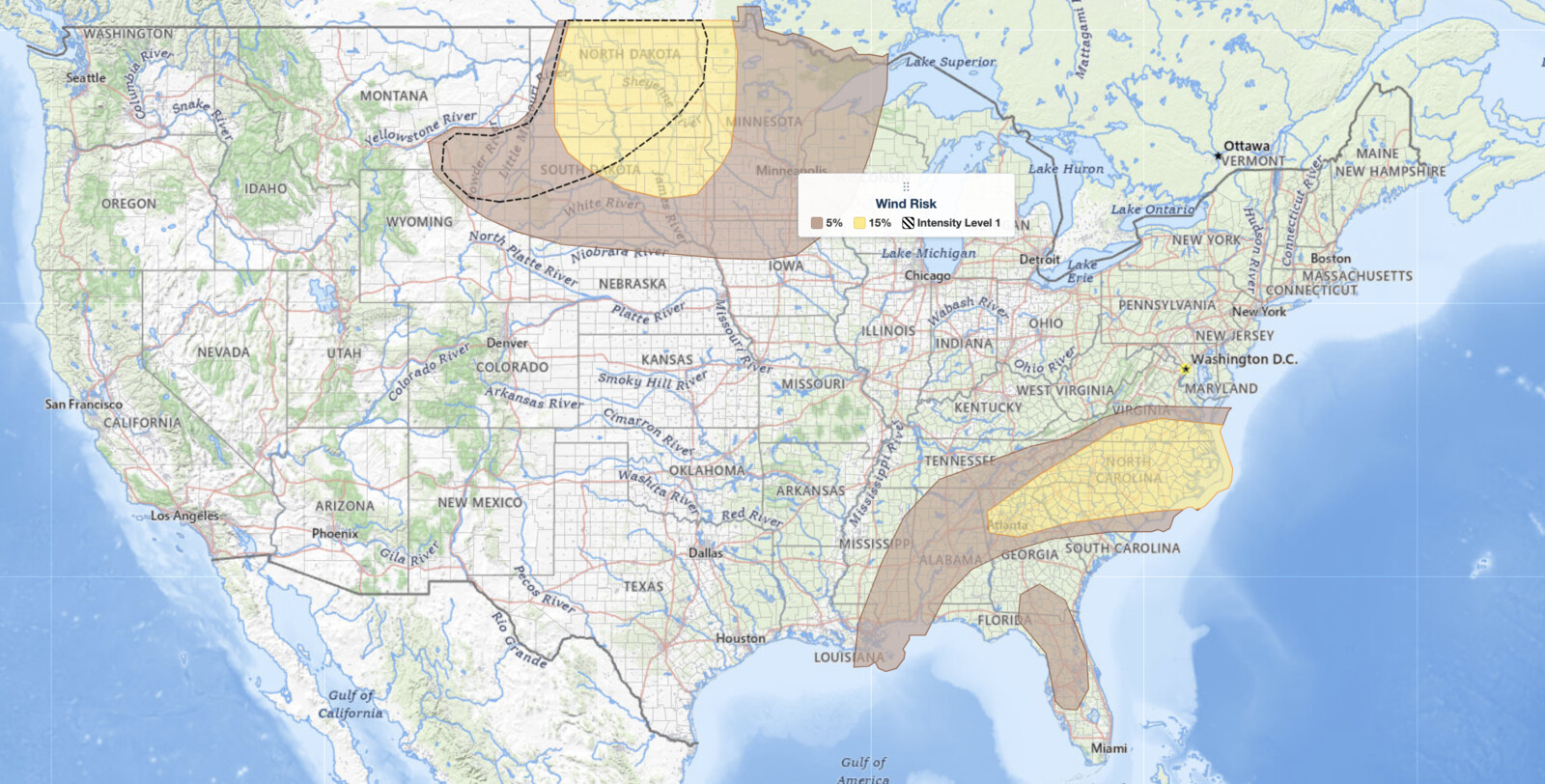
Southeast severe thunderstorms are the lead hazard in today’s Storm Prediction Center Day 1 Convective Outlook, issued July 19, 2026, with the SPC placing a Slight Risk, the second of five severe categories (level 2 of 5), over a corridor stretching from north Georgia through the Carolinas and into southern Virginia, as well as across the Dakotas into western Minnesota. SPC uses a five-tier system to communicate severe weather potential; you can read the full breakdown in this SPC outlook risk categories explainer. Damaging winds are the primary concern in the Southeast this afternoon, while the Dakotas and western Minnesota face a combined threat of damaging winds and large hail later today into the evening.
Key points:
- Slight Risk (level 2 of 5) covers north Georgia to southern Virginia and the Dakotas into western Minnesota.
- Damaging winds are the top hazard in the Southeast; hail and wind threaten the Dakotas and western Minnesota.
- SPC hazard probabilities reach 15% for both large hail and damaging winds within risk areas.
- Storms are expected this afternoon in the Southeast and this afternoon through evening in the Northern Plains.
- A cold front and a closed Canadian low are the main atmospheric drivers for both severe areas.
Southeast Severe Thunderstorms and a Northern Plains Threat: Where and When
The SPC’s discussion identifies two geographically separate areas of concern for July 19. In the Southeast, the threat focuses on north Georgia, the Carolinas, and southern Virginia, where severe storms are expected to fire this afternoon ahead of a sagging cold front. Farther north, parts of the Dakotas and western Minnesota face their own round of severe weather this afternoon and continuing into the evening hours as a closed low digs southeast toward the Upper Midwest.
Both regions sit within the Slight Risk zone, meaning scattered severe storm coverage is likely but a widespread outbreak is not expected. Marginal Risk areas buffer the Slight zone on its fringes, indicating that isolated severe storms remain possible even beyond the highest-risk corridors. Travelers and residents in all of these corridors should monitor conditions closely throughout the day.
Meteorologist’s Take
The large-scale setup behind today’s Southeast severe thunderstorms and the Northern Plains storms pits a western U.S. ridge against an eastern U.S. trough, a pattern that channels energy into both severe weather zones.
In the Southeast, a surface cold front is dragging southward out of coastal Virginia. To its south, temperatures are climbing into the low-to-mid 90s Fahrenheit across north Georgia and the surrounding region, while surface dewpoints sit in the upper 60s to low 70s Fahrenheit. That combination produces a strongly unstable air mass, with the SPC’s HREF ensemble forecasting Mixed-layer CAPE values of 1,500 to 2,000 J/kg. Precipitable water values exceed 1.75 inches over much of the area, with a band topping 2 inches, and sub-cloud lapse rates approaching 8 degrees Celsius per kilometer.
In plain terms, the atmosphere is loaded with moisture and instability, and any thunderstorm that can sustain a strong updraft will be capable of producing damaging winds at the surface.
In the Northern Plains, a closed low over the Canadian Prairies is forecast to crest the western ridge and dig southeast toward the Upper Midwest late in the day. That approaching upper-level energy, combined with the cold front lifting northward through the Mississippi Valley, will trigger afternoon and evening convection across the Dakotas and western Minnesota. This scenario favors both large hail and damaging winds as storms organize in an environment primed by the approaching trough. The SPC sets the probability of large hail and damaging winds each at 15% within the risk areas for the event as a whole.
How to Stay Safe from Damaging Winds and Large Hail
Because damaging winds and large hail are the named hazards for today’s Southeast severe thunderstorms and for the Dakotas and western Minnesota, your safety actions should center on those specific threats. If a severe thunderstorm warning is issued for your county, move away from windows and seek an interior room on the lowest floor of a sturdy building. Wind gusts associated with severe thunderstorms can down trees and power lines rapidly, so stay off roads where possible and avoid parking under trees or canopies during active storms.
Large hail can shatter windshields and damage vehicles in seconds. If you are driving and hail begins to fall, pull off the road safely and angle the vehicle so hail strikes the front rather than the side windows. Do not leave shelter until the storm has clearly passed and local emergency managers have given the all-clear. You can track active severe thunderstorm warnings in real time with iAlert’s active weather alerts and monitor storm movement on the iAlert live radar.
With both rounds of Southeast severe thunderstorms and Northern Plains activity expected during daytime hours, conditions can deteriorate faster than the average 13-minute warning lead time. Sign up for county-level alerts through iAlert weather alerts and notifications so warnings reach you wherever you are this afternoon and evening.
Sources:
Get Severe Weather Alerts for Your Location
When any NWS watch, warning, or advisory is issued for your area, iAlert sends you an immediate notification by email, text message, or phone call, 24 hours a day, 7 days a week.
Sign Up for Severe Weather Alerts →

