
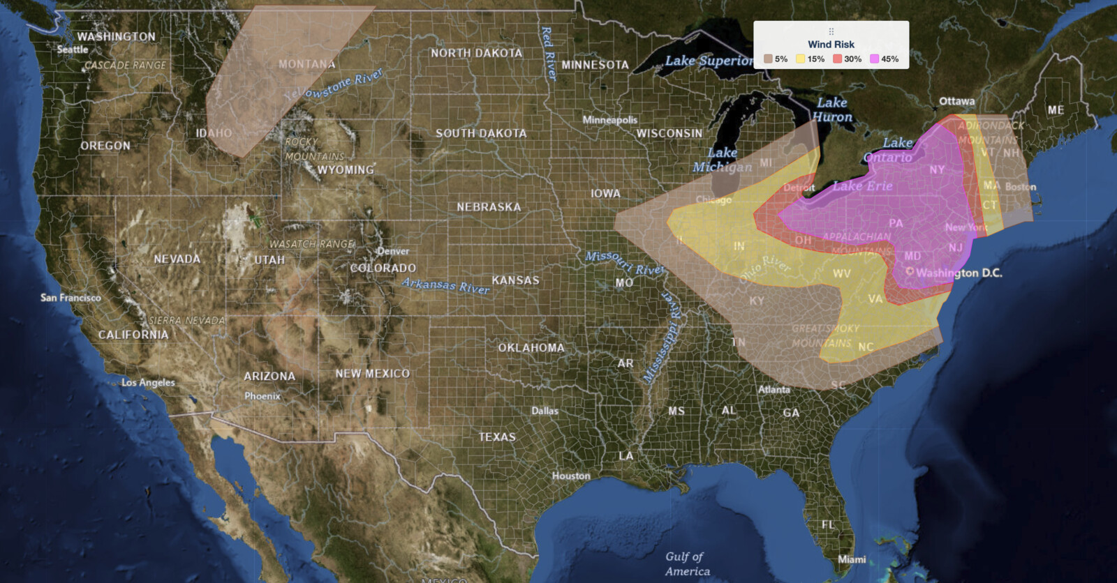
Northeast severe thunderstorms are expected to bring widespread damaging winds, large hail, and a tornado threat to a corridor stretching from the Ohio Valley and Lower Great Lakes through the Mid-Atlantic and into New England on Saturday, July 18, 2026. The NOAA Storm Prediction Center has placed this region under an Enhanced Risk, the third of five severe categories (level 3 of 5), with hazard activity forecast to begin this afternoon and linger into late tonight.
Key points:
- Enhanced Risk (3 of 5) covers the Northeast, Mid-Atlantic, and Lower Great Lakes.
- Damaging wind gusts carry a 45% SPC probability, the primary hazard today.
- Tornadoes, some possibly strong, are possible near southeastern PA, NJ, and southern NY.
- MLCAPE values of 2,000 to 3,000 J/kg expected by early afternoon.
- The Northeast severe thunderstorms threat continues from this afternoon through late tonight.
What the SPC Is Forecasting
The SPC outlook names a broad swath of the eastern United States as the focus for today’s Northeast severe thunderstorms. The highest-end risk is centered on portions of the Ohio Valley, Lower Great Lakes, Mid-Atlantic, and the Northeast, with the severe threat developing this afternoon and extending into the overnight hours. SPC’s stated hazard probabilities within the Enhanced Risk area are: damaging wind at 45 percent, large hail at 5 percent, and tornadoes at 5 percent, making destructive wind gusts the dominant concern.
The tornado threat is geographically more specific. The SPC discussion highlights southeastern Pennsylvania, New Jersey, and southern New York as the zone where a couple of tornadoes, some possibly strong, may occur. That area sits near an advancing warm front where backed low-level winds and effective storm-relative helicity values of 200 to 300 m²/s² create favorable rotation potential. Residents in those counties should treat today’s outlook with extra seriousness.
Early morning clusters of showers and thunderstorms are already possible across central Pennsylvania and southern New York as the day begins. Guidance suggests the air mass south and east of those storms recovers significantly by midday, with dewpoints climbing into the mid-70s across much of the Mid-Atlantic. That recovery sets the stage for rapid afternoon intensification. SPC uses a five-tier system to communicate severe weather potential; you can explore how each SPC outlook risk category works for more detail.
Meteorologist’s Take on the Northeast Severe Thunderstorms
The engine driving these Northeast severe thunderstorms is an unseasonably strong upper-level trough pushing south out of Ontario and into the northeastern United States through early Sunday. As that trough deepens, a mid-level jet exceeding 60 knots will overspread eastern Canada and the Northeast, pulling a surface low deeper across the eastern St. Lawrence Valley. That surface low is the anchor for a warm front lifting northward across eastern New York and southern New England, while a cold front trailing across the Ohio Valley and Great Lakes acts as an additional trigger for storm development.
South of the warm front, very moist and nearly cap-free air is in place. Even limited afternoon heating is enough to push mixed-layer CAPE to 2,000 to 3,000 J/kg by early afternoon, a substantial instability value. Deep-layer wind shear of 35 to 45 knots is also present, a range that can support organized supercell structures alongside more linear storm modes. The SPC notes that the convective evolution is highly uncertain because multiple forcing regimes are active simultaneously, meaning storm clusters could merge, re-intensify, or evolve in ways that shift the wind and tornado threats in timing and location through the evening.
The key takeaway for today’s Northeast severe thunderstorms is that widespread damaging gusts are the most likely outcome across a large portion of the Northeast and Mid-Atlantic, but embedded supercells near the warm-front boundary could produce tornadoes and hail before any broader linear structure consolidates. Monitor live radar and active alerts closely as storms develop this afternoon.
How to Stay Safe From Today’s Northeast Severe Thunderstorms
Because damaging winds are the headline hazard for these Northeast severe thunderstorms, your first priority is identifying a sturdy interior shelter away from windows and exterior walls. Wind gusts strong enough to down trees and power lines can make outdoor areas and vehicles dangerous well before a formal warning is issued. Stay off roads if widespread tree and wire debris is reported in your area.
If you are in southeastern Pennsylvania, New Jersey, or southern New York, the tornado threat from these Northeast severe thunderstorms elevates your risk level. Know the difference between a Tornado Watch and a Tornado Warning before storms arrive, and identify your lowest-level interior room or basement now. Do not wait for a warning to start moving.
Large hail at the 5 percent probability level is a secondary but real risk. Move vehicles into a garage or under solid cover before afternoon storms develop. Check active weather alerts for your location throughout the afternoon and evening, as conditions will evolve quickly across this large and complex severe weather setup.
Sources:
Get Severe Weather Alerts for Your Location
When any NWS watch, warning, or advisory is issued for your area, iAlert sends you an immediate notification by email, text message, or phone call, 24 hours a day, 7 days a week.
Sign Up for Severe Weather Alerts →

