
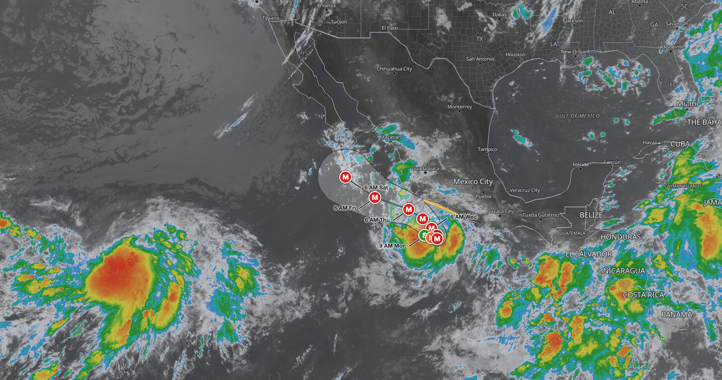
Tropical Storm Polo is rapidly intensifying offshore of southwestern Mexico, centered about 255 miles south-southeast of Manzanillo, Mexico, with maximum sustained winds of 65 mph as of the 9 AM CST advisory on Monday, September 21, 2026. The National Hurricane Center expects Polo to become a hurricane by Monday afternoon and a major hurricane on Tuesday, and a Tropical Storm Watch is in effect from Tecpan de Galeana to Punta San Telmo.
Key points:
- Tropical Storm Polo: 65 mph winds, 997 mb, hurricane expected Monday afternoon.
- Tropical Storm Watch in effect: Tecpan de Galeana to Punta San Telmo, Mexico.
- Peak forecast intensity 160 mph, Category 5, Wednesday evening into Thursday morning.
- Rainfall of 4 to 8 inches, isolated 12 inches, in Guerrero and Michoacán.
- Life-threatening surf and rip currents begin along southwestern Mexico Tuesday.
Get Severe Weather Alerts for Your Location
When any NWS watch, warning, or advisory is issued for your area, iAlert sends you an immediate notification by email, text message, or phone call, 24 hours a day, 7 days a week.
Sign Up for Severe Weather Alerts →Where Tropical Storm Polo stands Monday morning
At 9 AM CST (11 AM EDT) Monday, the center was located near latitude 15.4 North, longitude 103.4 West, about 255 miles south-southeast of Manzanillo and about 200 miles southwest of Zihuatanejo, Mexico. Maximum sustained winds had increased to near 65 mph with higher gusts, and the estimated minimum central pressure was 997 mb (29.44 inches). The system was moving east near 5 mph.
The wind field around Tropical Storm Polo is uneven. Tropical-storm-force winds reach farthest in the southeast quadrant, about 70 miles from the center, and extend about 60 miles in the northeast quadrant, but stop short at roughly 25 miles in the southwest and northwest quadrants. Winds of 58 mph reach about 25 miles northeast and southeast of the center and are absent in the western half.
Seas of 13 feet or higher extend up to 50 miles from the center in the northeast, southeast and northwest quadrants and 35 miles to the southwest, and the National Hurricane Center has requested 3-hourly ship reports within 300 miles of the center.
The Tropical Storm Watch covers the coast from Tecpan de Galeana, Guerrero, to Punta San Telmo, Michoacán, a stretch that includes Zihuatanejo. A Tropical Storm Watch means tropical storm conditions are possible within the watch area, generally within 48 hours; forecasters say those conditions are possible there by Tuesday night or early Wednesday. NHC added that the watch will likely be expanded westward later Monday or Monday night.
Tropical Storm Polo forecast: rapid intensification toward 160 mph
The official forecast for Tropical Storm Polo carries the system to 100 mph, a Category 2 hurricane, by 6 PM CST Monday, and to 120 mph, a Category 3 major hurricane, by 6 AM CST Tuesday. Strengthening continues to 145 mph Tuesday evening and 155 mph Wednesday morning, with peak intensity of 160 mph, Category 5, forecast from 6 PM CST Wednesday, September 23, through 6 AM CST Thursday, September 24.
The closest approach in the forecast comes at 6 AM CST Thursday, when the center is projected about 105 miles south-southwest of Manzanillo at 160 mph. The advisory calls for slow eastward or southeastward motion through Monday night, followed by a sharp turn toward the west-northwest or northwest by late Tuesday. A mid-level ridge is expected to build over Mexico by late Tuesday, steering Polo west-northwest or northwest from Wednesday into late week, which could bring the core near or south of the southwestern Mexico coast Thursday and then south of the Baja California Peninsula on Saturday.
Confidence in the path of Tropical Storm Polo is low. The Hurricane Center notes a large north-south spread in the track guidance, with the newest forecast nudged southward, and says that although the core is forecast to stay offshore, it is too soon to determine the exact location or magnitude of impacts. NHC’s average track errors run about 115 miles on day 4 and 145 miles on day 5, and average intensity error is about 17 mph each day. The forecast cone shows the probable track of the center, not the size of the storm or the reach of its impacts.
| Forecast time (CST, local) | Position | Max winds | Status | Distance from Manzanillo, Mexico |
|---|---|---|---|---|
| Mon Sep 21, 9 AM | 15.4N 103.4W | 65 mph | Tropical storm | 255 mi SSE |
| Mon Sep 21, 6 PM | 15.2N 102.8W | 100 mph | Category 2 hurricane | 285 mi SSE |
| Tue Sep 22, 6 AM | 15.1N 102.3W | 120 mph | Category 3 hurricane | 305 mi SSE |
| Tue Sep 22, 6 PM | 15.4N 102.3W | 145 mph | Category 4 hurricane | 285 mi SSE |
| Wed Sep 23, 6 AM | 16.0N 102.8W | 155 mph | Category 4 hurricane | 235 mi SSE |
| Wed Sep 23, 6 PM | 16.8N 103.6W | 160 mph | Category 5 hurricane | 165 mi SSE |
| Thu Sep 24, 6 AM | 17.6N 104.8W | 160 mph | Category 5 hurricane | 105 mi SSW |
| Fri Sep 25, 6 AM | 18.6N 107.8W | 150 mph | Category 4 hurricane | 230 mi W |
| Sat Sep 26, 6 AM | 20.3N 110.4W | 140 mph | Category 4 hurricane | 405 mi WNW |
Meteorologist’s take
The environment described in the NHC Forecast Discussion is about as favorable as the eastern Pacific gets. Forecasters point to a small inner core over very warm and untapped water above 30.5 degrees Celsius, light vertical wind shear and plentiful mid-level moisture, and call conditions “ideal for explosive intensification during the next day or two.” Satellite images show a developing central dense overcast with very deep convection, and microwave data reveal a small eye with hints of a banded eyewall.
What stands out is the model agreement. Every model responds to these conditions with rapid intensification, and the forecaster wrote that the SHIPS rapid intensification index is “showing percentages as high as I have ever seen them.” Even the aggressive official forecast sits below the HCCA corrected-consensus aid, which taken literally would be at least a 99th percentile intensification event. NHC expects Polo to be “a small but very dangerous hurricane by tomorrow and beyond,” and a NOAA Hurricane Hunter aircraft was en route to refine the intensity estimate.
Small tropical cyclones can spin up quickly because there is less mass to accelerate, and the same trait leaves them prone to sharp swings in both directions later. That is one reason the intensity numbers attached to Tropical Storm Polo deserve a check every advisory cycle rather than once a day. The core is forecast to stay offshore, yet the heaviest rain and the worst surf do not require a landfall to reach the coast.
How to stay safe as Tropical Storm Polo intensifies
Rainfall is the headline land threat. Polo is expected to produce 4 to 8 inches of rain, with isolated maximum totals up to 12 inches, across coastal portions of Guerrero and Michoacán through Thursday, and 3 to 6 inches in coastal Oaxaca, Colima and Jalisco. NHC warns this rain may produce life-threatening flooding and mudslides, especially in areas of steep terrain, so people below slopes or near swollen streams should identify higher ground now.
Along the water, swells generated by Tropical Storm Polo begin affecting portions of the southwestern Mexico coast on Tuesday and are likely to cause life-threatening surf and rip current conditions. Stay out of the surf and off exposed rocks and jetties even when the sky looks calm. Mariners should expect seas of 13 feet or higher within about 50 miles of the center, and rougher conditions near the core as Polo strengthens.
Residents inside the Tropical Storm Watch area from Tecpan de Galeana to Punta San Telmo should finish preparations before conditions arrive Tuesday night or early Wednesday, and everyone farther west, including Manzanillo, should watch for a possible expansion of the watch. Travelers with plans on this coast this week should confirm flights and lodging and follow guidance from Mexico’s civil protection authorities and national meteorological service.
Track the system on the iAlert hurricane tracker for position and intensity updates. For locations in the United States, iAlert weather alerts deliver NWS watches and warnings the moment they are issued, without hunting for them.
Tropical Storm Polo FAQ
Will Tropical Storm Polo make landfall in Mexico?
The official forecast keeps the core offshore, passing about 105 miles south-southwest of Manzanillo Thursday morning, but NHC calls this a low-confidence track and says it is too soon to determine the exact location or magnitude of impacts. A Tropical Storm Watch covers Tecpan de Galeana to Punta San Telmo, and heavy rain reaches the coast either way.
How strong could Polo get?
The forecast peak is 160 mph, a Category 5 hurricane, from 6 PM CST Wednesday through 6 AM CST Thursday. Polo is expected to reach hurricane strength Monday afternoon and major hurricane strength on Tuesday.
Where is the storm headed?
Slowly east or southeast through Monday night, then sharply toward the west-northwest or northwest by late Tuesday. The track could carry the core near or south of southwestern Mexico Thursday and south of the Baja California Peninsula Saturday.
How much rain is expected?
Coastal Guerrero and Michoacán can expect 4 to 8 inches through Thursday, with isolated totals up to 12 inches. Coastal Oaxaca, Colima and Jalisco may see 3 to 6 inches, with life-threatening flooding and mudslides possible.
Updates on Tropical Storm Polo arrive frequently: the next intermediate advisory is set for 12 PM CST (2 PM EDT) and the next complete advisory for 3 PM CST (5 PM EDT) Monday. Given the low-confidence track and the extreme rate of strengthening, treat every forecast point beyond Tuesday as subject to change and recheck the official advisories before acting.
Sources:
- NHC Tropical Storm Polo Public Advisory Number 4
- NHC Tropical Storm Polo Forecast Discussion Number 4
- NHC Tropical Storm Polo Forecast/Advisory Number 4
- NHC Polo advisory archive (all products)
Get Severe Weather Alerts for Your Location
When any NWS watch, warning, or advisory is issued for your area, iAlert sends you an immediate notification by email, text message, or phone call, 24 hours a day, 7 days a week.
Sign Up for Severe Weather Alerts →

