
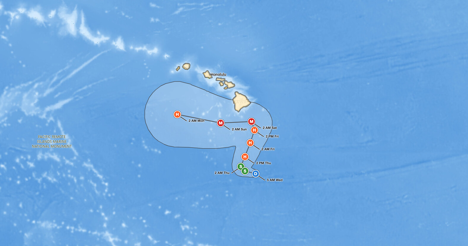
The Big Island hurricane threat is rising quickly as Tropical Depression Fifteen-E, centered about 320 miles south-southeast of South Point, Hawaii, at 5 AM HST on Wednesday, September 23, 2026, is forecast to become a tropical storm later today, a hurricane on Thursday, and possibly a major hurricane by the weekend. Forecasters expect rainfall totals of 15 to 20 inches across the Big Island, with maximum amounts near 35 inches, which may produce catastrophic, life-threatening flooding and mudslides in areas of steep terrain.
Big Island hurricane threat, key points:
- Fifteen-E: 35 mph, about 320 miles south-southeast of South Point, Hawaii.
- Forecast: tropical storm today, hurricane Thursday, 115 mph by Saturday.
- Closest forecast point: about 80 miles southeast of South Point, 2 AM HST Saturday.
- Rain: 15 to 20 inches on the Big Island, 5 to 10 inches on Maui.
- A Hurricane or Tropical Storm Watch will likely be required for part of the state later today.
- Life-threatening surf adds to the Big Island hurricane threat starting Friday.
Get Severe Weather Alerts for Your Location
When any NWS watch, warning, or advisory is issued for your area, iAlert sends you an immediate notification by email, text message, or phone call, 24 hours a day, 7 days a week.
Sign Up for Severe Weather Alerts →Where the Big Island hurricane threat stands now
At 5 AM HST (1500 UTC, 8:00 am PDT, 11:00 am EDT) Wednesday, the center of Tropical Depression Fifteen-E was near latitude 14.5 North, longitude 154.4 West, about 320 miles south-southeast of South Point, Hawaii, and about 525 miles south-southeast of Honolulu. Maximum sustained winds were near 35 mph with higher gusts, and the minimum central pressure was estimated at 1004 mb (29.65 inches).
The depression was moving west-northwest near 6 mph. A tropical depression has sustained winds of 38 mph or less; a tropical storm runs 39 to 73 mph, a hurricane 74 mph or more, and a major hurricane is Category 3 or higher at 111 mph or more.
No watches or warnings were in effect at advisory time. The National Hurricane Center, which is issuing the Central Pacific Hurricane Center advisories on this system, states that a Hurricane or Tropical Storm Watch will likely be required for a portion of the state later today, and that interests across the Hawaiian Islands should closely monitor the system. The next complete advisory is due at 11 AM HST (5:00 pm EDT). If you are unclear on the difference between a watch and a warning, iAlert covers the terms in know the hurricane hazard terms.
For now the Big Island hurricane threat is a forecast rather than an observation. The system is still a depression, the closest approach is roughly three days out, and that is the window in which preparation is advised
Forecast track and intensity behind the Big Island hurricane threat
Forecasters expect the west-northwest motion to continue for the next day or so, followed by a sharp turn to the north and north-northeast on Thursday that continues through the end of the week. On that track, the system approaches the Big Island of Hawaii on Friday and Saturday.
The official forecast brings Fifteen-E to tropical storm strength by 2 PM HST Wednesday, to a Category 1 hurricane at 75 mph by 2 PM HST Thursday, and to a peak of 115 mph at both the 2 AM HST Saturday, September 26, and 2 AM HST Sunday, September 27, forecast points. The closest forecast point to South Point, Hawaii, is about 80 miles southeast of it at 2 AM HST Saturday, as a Category 3 hurricane with 115 mph winds; the closest point to Honolulu is about 230 miles south-southeast at 2 AM HST Sunday.
Uncertainty is real and quantified: NHC average track errors run about 175 miles on day 4 and 230 miles on day 5, with intensity errors near 23 mph each day. The forecast cone shows the probable track of the center, not the size of the storm or the reach of its impacts, so the Big Island hurricane threat is not confined to the line on the map.
Advisory 12 forecast track behind the Big Island hurricane threat. Distances are measured from South Point, the southern tip of the Big Island.
| Forecast time (HST) | Position | Max winds | Status | Distance from South Point, Hawaii |
|---|---|---|---|---|
| Wed Sep 23, 5 AM | 14.5N 154.4W | 35 mph | Tropical depression | 320 mi SSE |
| Wed Sep 23, 2 PM | 14.7N 155.2W | 45 mph | Tropical storm | 295 mi S |
| Thu Sep 24, 2 AM | 15.0N 155.5W | 60 mph | Tropical storm | 270 mi S |
| Thu Sep 24, 2 PM | 15.7N 155.2W | 75 mph | Category 1 hurricane | 225 mi S |
| Fri Sep 25, 2 AM | 16.7N 154.8W | 90 mph | Category 1 hurricane | 165 mi SSE |
| Fri Sep 25, 2 PM | 17.6N 154.5W | 105 mph | Category 2 hurricane | 120 mi SE |
| Sat Sep 26, 2 AM | 18.2N 154.7W | 115 mph | Category 3 hurricane | 80 mi SE |
| Sun Sep 27, 2 AM | 18.1N 157.0W | 115 mph | Category 3 hurricane | 105 mi WSW |
| Mon Sep 28, 2 AM | 18.7N 160.2W | 110 mph | Category 2 hurricane | 295 mi W |
Meteorologist’s take on the Big Island hurricane threat
Satellite imagery shows the depression becoming better organized, with banding features more defined on the western and northern sides and expanding outflow. The catch is structural: the low-level circulation sits on the southeastern edge of the deep convection and is not well aligned with the deep convective mass, and satellite intensity estimates spread widely, from about 25 to 40 knots (30 to 45 mph). That misalignment is why forecasters held the initial intensity at 30 knots, a value also supported by a recent OSCAT scatterometer pass, and expect slow strengthening at first.
Once an inner core develops, the environment looks favorable: low vertical wind shear, high mid-level moisture, and sea surface temperatures of 28 to 29 degrees Celsius (82 to 84 degrees Fahrenheit). Rapid intensification probabilities are increasing, and the two best-performing model aids, Google DeepMind and HCCA, both show a major hurricane in a few days, which is why the NHC intensity forecast was raised from the previous advisory.
The track reasoning is where the Big Island hurricane threat gets complicated. A ridge northeast of Hawaii is forecast to weaken and slide eastward as a mid-latitude trough drops over the northwestern Hawaiian Islands, an evolution likely to cause the cyclone to slow later today or tonight and then turn northward or north-northeastward by Thursday with some increase in forward speed. The trough is then forecast to move westward this weekend as the ridge rebuilds north of Hawaii, which should force a sharp westward turn while the cyclone is close to the Big Island.
Exactly when that turn happens is unknowable at this range, and there is a large north-south spread in the guidance. The current NHC forecast sits on the northern side of the track envelope, meaning small timing shifts translate into large differences in how close the center comes to land. The scale of the Big Island hurricane threat hinges on the timing of that turn at least as much as on peak intensity.
Rain, flooding, and surf hazards in the Big Island hurricane threat
Rainfall is the headline hazard, and it is the first piece of the Big Island hurricane threat to arrive. The Big Island is forecast to see 15 to 20 inches with maximum amounts of 35 inches, and that rainfall may produce catastrophic, life-threatening flooding and mudslides, especially in areas of steep terrain. Maui is forecast to see 5 to 10 inches with maximum amounts of 20 inches, with life-threatening flooding and mudslides possible, again most likely over high terrain.
Across the rest of the Hawaiian Islands, totals of 1 to 3 inches with maximum amounts of 6 inches are expected, with isolated flooding possible, so the rainfall side of the Big Island hurricane threat falls off sharply west of Maui. Heavy rain becomes more likely on Thursday and Friday and is likely to continue across the Big Island and Maui through the weekend.
Swells are expected to reach the east and south-facing shores of the Big Island on Friday, spreading westward and building through the weekend, and those swells are likely to cause life-threatening surf and rip current conditions. There is an increasing risk of wind impacts in the Hawaiian Islands regardless of the exact track. Mariners should note that NHC has requested 3-hourly ship reports within 300 miles of the center.
How to stay safe in the Big Island hurricane threat
Use the time available today. Forecasters say the time to prepare for significant heavy rain and flooding impacts on the Big Island is now, before conditions deteriorate on Thursday and Friday. Finish supply runs, secure loose outdoor items against wind, and confirm that your household preparedness plan is in place.
Know your flood and landslide exposure. With 15 to 20 inches of rain forecast for the Big Island and up to 20 inches possible on Maui, steep terrain, stream crossings, and low-lying roads are the danger zones. Never drive into water covering a road, and move to higher ground if water begins rising near your home; iAlert’s guide to flood safety during a flood covers the rest.
the rest.Stay out of the ocean once swells arrive on Friday, because life-threatening surf and rip currents are expected along east and south-facing shores. Track watch and warning updates on the iAlert hurricane tracker and keep active weather alerts open on your phone, since a watch may be issued for part of the state later today. Residents and visitors should treat the Big Island hurricane threat as a plan-now situation rather than a wait-and-see one.
Big Island hurricane threat FAQ
Does Tropical Depression Fifteen-E create a Big Island hurricane threat?
Yes. Forecasters say there is an increasing risk of wind and wave impacts in the Hawaiian Islands regardless of the exact track, and the system is expected to approach the Big Island on Friday and Saturday.
How strong could the storm get?
The forecast peaks at 115 mph, a Category 3 major hurricane, at the 2 AM HST Saturday, September 26, and 2 AM HST Sunday, September 27, forecast points. NHC intensity errors average about 23 mph per day.
Where is the storm headed?
West-northwest near 6 mph for the next day or so, then a sharp turn to the north and north-northeast on Thursday. The closest forecast point is about 80 miles southeast of South Point at 2 AM HST Saturday.
Is a hurricane watch in effect for the Big Island?
Not as of Advisory 12. NHC says a Hurricane or Tropical Storm Watch will likely be required for a portion of the state later today, and that a Hurricane Watch may be required for the Big Island. That would be the first official watch tied to this Big Island hurricane threat, and a watch means hurricane conditions are possible within 48 hours.
When do impacts begin on the islands?
The Big Island hurricane threat starts with rain. Heavy rain becomes more likely on Thursday and Friday and continues through the weekend on the Big Island and Maui. Swells reach east and south-facing Big Island shores on Friday, building westward through the weekend.
iAlert will update this post as new advisories arrive. The Big Island hurricane threat is re-evaluated on a six-hour cycle, with complete advisories at 5 AM, 11 AM, 5 PM, and 11 PM HST.
Sources:
- NHC/CPHC Tropical Depression Fifteen-E Public Advisory Number 12
- NHC/CPHC Tropical Depression Fifteen-E Forecast Discussion Number 12
- NHC/CPHC Tropical Depression Fifteen-E Forecast/Advisory Number 12
Get Severe Weather Alerts for Your Location
When any NWS watch, warning, or advisory is issued for your area, iAlert sends you an immediate notification by email, text message, or phone call, 24 hours a day, 7 days a week.
Read More

Arizona Severe Thunderstorms: SPC Enhanced Risk for Flagstaff and Prescott on October 21, 2026
Arizona severe thunderstorms are the headline threat in the NOAA Storm Prediction Center's updated Day 1 Convective Outlook for Wednesday, October 21, 2026, issued 12:30 UTC (5:30 am MST / 8:30 am EDT). The outlook places…

Mid-Atlantic Severe Thunderstorms: SPC Slight Risk for Damaging Wind and Tornado Risk on October 16, 2026
Mid-Atlantic severe thunderstorms are the focus of the NOAA Storm Prediction Center's updated Day 1 Convective Outlook, issued 12:42 UTC (8:42 am EDT) on October 16, 2026. It keeps a Slight Risk, level 2 of 5…

Southern Plains Severe Storms: SPC Slight Risk for Oklahoma and West Texas on October 14, 2026
Southern Plains severe storms are the main severe weather concern across the country on Wednesday, October 14, 2026, with the NOAA Storm Prediction Center placing Oklahoma City, Lawton and Ardmore in Oklahoma, along with Midland, Odessa…