
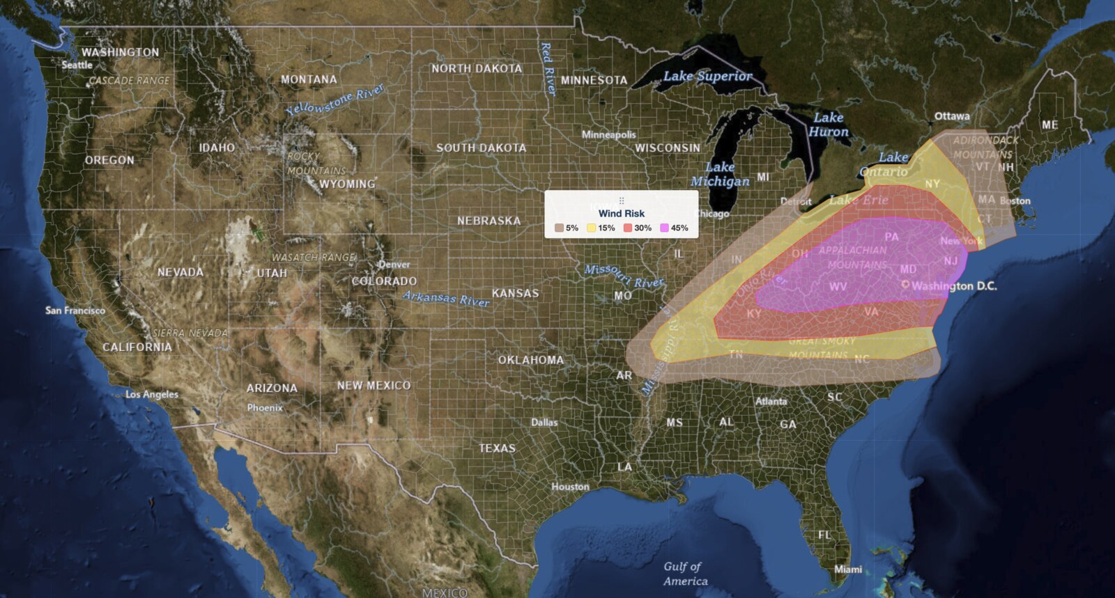
Upper Ohio Valley severe weather is the headline threat on July 21, 2026, as the NOAA Storm Prediction Center (SPC) has issued an Enhanced Risk stretching from the Ohio Valley through the Mid-Atlantic and into the Northeast. The SPC places damaging wind gusts as the primary hazard this afternoon and early evening, with large hail and a few tornadoes also possible across the broad pre-frontal warm sector.
Key points:
- Enhanced Risk (level 3 of 5) covers the Upper Ohio Valley into the Mid-Atlantic.
- Damaging wind gusts are the top hazard; SPC sets wind probability at 45 percent.
- Large hail probability reaches 15 percent; tornado probability sits at 5 percent.
- Storms are expected to develop this afternoon and continue into the early evening hours.
- The Mid-South and Tennessee Valley also face widely scattered severe storm chances.
Where and When the Threat Is Greatest
The SPC’s Enhanced Risk is the third of five categories on the agency’s five-tier severe weather scale, and it targets the lower Ohio Valley into the Mid-Atlantic as the core zone for Upper Ohio Valley severe weather. You can learn how every tier works at the iAlert severe weather outlook explainer. Organized storm clusters and supercells are expected to develop ahead of an eastward-moving cold front during the afternoon hours and then spread east through the evening.
South and west of the Enhanced area, portions of the Mid-South and Tennessee Valley carry a lower severe threat. The SPC notes that greater instability exists in that region, but weaker deep-layer wind shear (roughly 30 to 40 knots of effective shear) limits how well storms can organize compared to areas farther northeast. Multicell clusters and occasional supercells are still possible there, capable of producing damaging wind gusts and isolated large hail.
Hazards to Expect Across the Region
For the primary Enhanced Risk zone, the SPC’s maximum hazard probabilities are: damaging wind gusts 45 percent, large hail 15 percent, and tornadoes 5 percent. Swaths of damaging wind gusts are the headline threat of today’s Upper Ohio Valley severe weather event, likely from organized storm clusters racing eastward. Any supercell that manages to sustain itself could produce large hail on top of the wind danger.
The tornado risk, while lower in probability, is not trivial. The SPC specifically notes that a gradually strengthening low-level jet reaching 30 knots will produce clockwise-curved hodographs, a wind profile that can support rotating updrafts. A few tornadoes may occur within the strongest supercell structures across the lower Ohio Valley and Mid-Atlantic corridor. Check active weather alerts for your area throughout the day so you can act quickly if a warning is issued.
Meteorologist’s Take
The driver behind today’s threat is a large-scale trough shifting across the northeastern United States, pulling a broad area of 40 to 50 knots of mid-level west-southwesterly winds over the Ohio Valley and Mid-Atlantic. In plain terms, that upper-level wind pattern provides the directional change with altitude (wind shear) that allows thunderstorms to organize into long-lived, rotating structures rather than collapsing quickly. An embedded impulse, a smaller disturbance riding in the base of the trough, will act as an extra trigger for storm development as it moves from the lower Ohio Valley toward the Mid-Atlantic.
Fuel for the storms comes from daytime heating and rich low-level moisture: dewpoints in the upper 60s to lower 70s degrees Fahrenheit across the pre-frontal warm sector will support moderate surface-based instability. Where that instability overlaps most efficiently with the 40 to 50 knots of effective shear, meaning from the lower Ohio Valley into the Mid-Atlantic, the SPC expects a mix of organized multicell clusters and discrete supercells. The storm mode matters because supercells are most capable of producing large hail and tornadoes, while fast-moving clusters most efficiently generate widespread damaging wind swaths.
The timing window of afternoon through early evening is important for the Upper Ohio Valley severe weather threat: instability peaks with daytime heating, but the approaching front and upper impulse keep storms going as the sun begins to lower. Residents across the entire corridor should anticipate rapidly changing conditions and have a way to receive warnings in real time.
How to Stay Safe During Upper Ohio Valley Severe Weather
Because damaging wind gusts are the primary risk, move vehicles into a garage or away from large trees before storms arrive. Winds strong enough to be classified as severe (58 mph or greater) can snap branches, topple shallow-rooted trees, and turn outdoor furniture into projectiles. Stay indoors and away from windows when storms are in your area.
With large hail also possible, cover or shelter vehicles, outdoor equipment, and livestock if you have time before storm arrival. For the tornado threat, know your shelter location in advance: an interior room on the lowest floor of a sturdy building, away from windows. Monitor live radar and alerts throughout the afternoon so you can track storm motion in real time. Sign up for location-based alerts through iAlert weather alerts and notifications to receive warnings the moment they are issued for your location.
Do not wait for storms to arrive to make your plan. Given the broad geographic scope of today’s Upper Ohio Valley severe weather threat, from the Ohio Valley all the way into the Northeast and Mid-Atlantic, conditions can deteriorate quickly and without extended lead time in fast-moving wind events.
Sources:
Get iAlert Notifications for Your Location
The moment a threat is issued for your area, iAlert sends an immediate alert by email, text message, or phone call, 24/7. Choose the alerts you need:
Severe Weather Alerts → ⚡ Lightning Detection Alerts →

