
Upper Midwest severe thunderstorms are the top weather story for Monday, July 27, 2026, as the NOAA Storm Prediction Center has issued an Enhanced Risk outlook covering the southern Great Lakes and adjacent Ohio Valley. Chicago, Milwaukee, South Bend, Fort Wayne, Detroit, and Toledo all sit inside the highest risk area. The primary threats are damaging wind gusts and large hail, with SPC assigning a 30% damaging wind probability and a 15% large hail probability across the core of the risk zone.
Key points:
- Enhanced Risk (level 3 of 5) covers northern Illinois, northern Indiana, southern Lower Michigan, southern Wisconsin, and northwest Ohio.
- Damaging wind gusts are the lead hazard, with a 30% wind probability and a hatched significant wind area for gusts of 75 mph or greater.
- Large hail is a secondary threat at 15% probability; the tornado probability is 2%.
- A fast-moving, forward-propagating MCS is expected to develop and intensify Monday into Monday night.
- A separate Slight Risk (level 2 of 5) covers southwest South Dakota, western Nebraska, northeast Colorado, and far northwest Kansas.
Where Upper Midwest Severe Thunderstorms Will Hit Hardest
The Enhanced Risk area, the third of five categories in SPC’s tiered outlook system, is centered on the southern Lake Michigan region. It reaches from southern Wisconsin and northern Illinois eastward across northern Indiana and southern Lower Michigan into northwest Ohio. Chicago and Detroit are both inside it.
SPC probabilities describe the chance of a severe report within 25 miles of any given point, so a 30% wind probability is a high number for a single day in late July. A broader Slight Risk wraps around the Enhanced area and extends south and east through the rest of Indiana and Ohio into Kentucky and West Virginia.
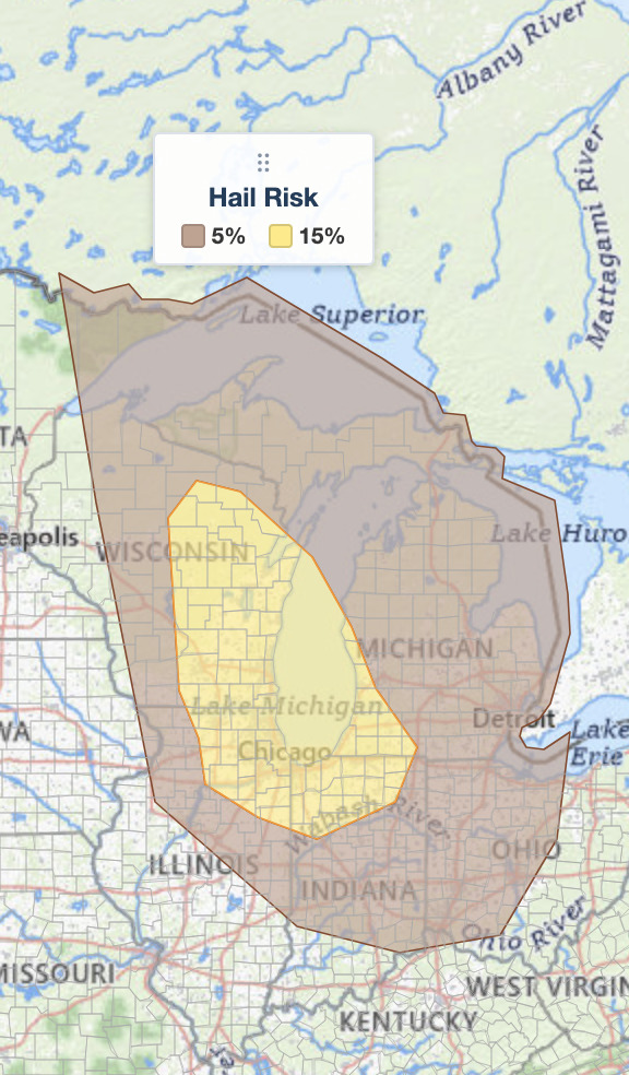
The 15% hail area is tighter than the wind threat and hugs the western half of the Enhanced Risk. That distribution is typical of this setup: the strongest updrafts capable of holding large hail aloft tend to occur early, before storms merge into a line and the hazard shifts almost entirely to wind.
Timing matters here. SPC expects the most intense storm activity to organize Monday morning near the Minnesota Arrowhead vicinity, then track southeastward into the Ohio and Tennessee Valleys through the late morning, afternoon, and evening. The Mid-Mississippi Valley corridor sits in the transitional zone, where the evolution of the early morning storms will heavily influence how severe Monday afternoon and evening become.
A secondary Slight Risk, level 2 of 5, affects southwest South Dakota, western Nebraska, northeast Colorado, and far northwest Kansas. SPC also flags more isolated damaging wind potential across the Mid-Atlantic, Tennessee Valley, central High Plains, and southeast Arizona, though those areas carry lower probabilities.
SPC uses a five-tier system to communicate severe weather potential; you can review each category in detail using this SPC outlook risk categories explainer. Check your local weather forecast for area-specific timing as the event unfolds.
Meteorologist’s Take: Why This MCS Could Turn Destructive
The atmosphere across the Upper Midwest is primed for organized storm activity Monday. Dewpoints of 70 degrees Fahrenheit or higher are in place from the Upper Midwest into the Ohio and Tennessee Valleys, indicating an exceptionally moist and unstable air mass. A diffuse cold front extends from a surface low over far southeast Manitoba southeastward to far eastern Upper Michigan, and at least one thunderstorm had already developed along that boundary over eastern Upper Michigan early Monday morning.
This is the second Enhanced Risk for the region in eight days. The July 20 Upper Midwest severe thunderstorms event was centered farther northwest across Minnesota, Wisconsin, and Upper Michigan, and produced gusts on the order of 70 mph. Today’s threat sits well southeast of that footprint, over the southern Lake Michigan corridor and the major metros along it.
The key dynamic is what meteorologists call a forward-propagating mesoscale convective system, or MCS: a single storm cluster that keeps regenerating along its own leading edge and races downstream faster than the individual storms inside it move. SPC notes that the overall setup matches classic scenarios for these long-lived clusters: a surface boundary running roughly parallel to the deep-layer wind shear, mid-level warm air being transported into the region, and very strong to extreme atmospheric instability. When those ingredients align, storms organize into a squall line capable of producing widespread damaging gusts along and just ahead of the leading edge.
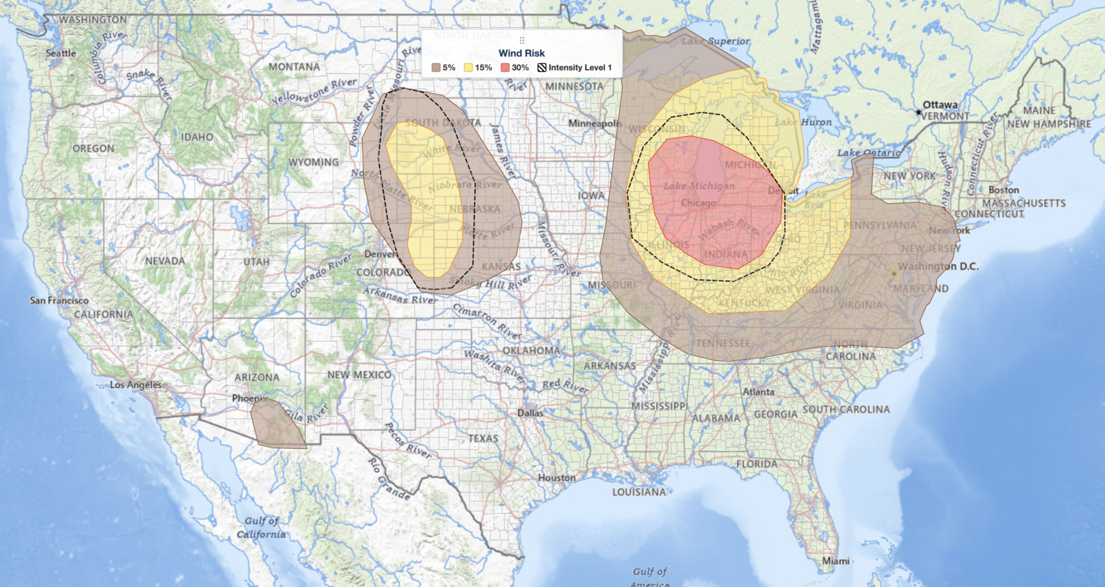
Confidence in that MCS was high enough for SPC to expand the 30% wind probability area westward and add a hatched significant wind zone, which flags the potential for gusts of 75 mph or greater. Forecasters acknowledge that even higher wind probabilities could become necessary as the day progresses and convective evolution becomes clearer.
In the central High Plains, a separate cluster of storms will be driven by different dynamics, keeping that Slight Risk zone distinct from the main Upper Midwest severe thunderstorms event to the east.
How to Stay Safe in Upper Midwest Severe Thunderstorms
Because damaging wind gusts are the primary hazard from today’s Upper Midwest severe thunderstorms, your first priority is to get inside a sturdy building well before storms arrive. Wind damage from an MCS can strike quickly and over a wide area, so do not wait until lightning is visible to seek shelter. Avoid windows and garage doors, which can fail under strong gusts, and stay away from trees and power lines both outside and along your driving route.
Large hail can crack windshields and dent vehicles in seconds. If you are driving when hail begins, pull safely off the road, stay inside the vehicle, keep your back to the windows, and cover yourself with a blanket or coat if one is available. After storms pass, be cautious of flooded roadways and downed power lines before returning outdoors.
Monitor live radar and active alerts throughout the day so you can track exactly when the strongest storms approach your location. Upper Midwest severe thunderstorms of this type can evolve rapidly, and real-time radar is your best tool for making timely decisions.
Upper Midwest Severe Thunderstorms FAQ
Where is the highest risk today?
The SPC Enhanced Risk covers northern Illinois, northern Indiana, southern Lower Michigan, southern Wisconsin, and northwest Ohio. Chicago, Milwaukee, South Bend, Fort Wayne, Detroit, and Toledo are all inside it.
How strong could the wind gusts get?
Inside the hatched significant wind zone, gusts of 75 mph or greater are possible. That is equivalent to a Category 1 hurricane and is enough to snap large tree limbs, down power lines, and damage roofs.
Are tornadoes expected with these Upper Midwest severe thunderstorms?
Tornadoes are not the main threat. The SPC tornado probability is 2%, meaning a brief spin-up embedded in the squall line is possible but not the primary concern. Damaging straight-line wind is.
When will storms arrive?
Storms organize Monday morning near the Minnesota Arrowhead, then track southeastward through the late morning, afternoon, and evening into the Ohio and Tennessee Valleys. The system is expected to continue intensifying into Monday night.
Sources:
Get Severe Weather Alerts for Your Location
When any NWS watch, warning, or advisory is issued for your area, iAlert sends you an immediate notification by email, text message, or phone call, 24 hours a day, 7 days a week.
Sign Up for Severe Weather Alerts →

