A dangerous heat wave has locked in across the central United States and is forecast to expand eastward through the week, reaching the East Coast in time for the Fourth of July weekend. The National Weather Service has Extreme Heat Warnings in effect from the Dakotas and Nebraska across the Upper Midwest, with Extreme Heat Watches already posted for the Northeast beginning midweek.
The heat is being driven by a strengthening upper-level high-pressure ridge. Afternoon temperatures will climb into the 90s and low 100s, with heat index values forecast as high as 105 to 115°F across the southern Plains, the mid-Mississippi Valley, and eventually the Mid-Atlantic. Much of the central and eastern U.S. rates Major to Extreme on the NWS HeatRisk scale, its two highest levels.
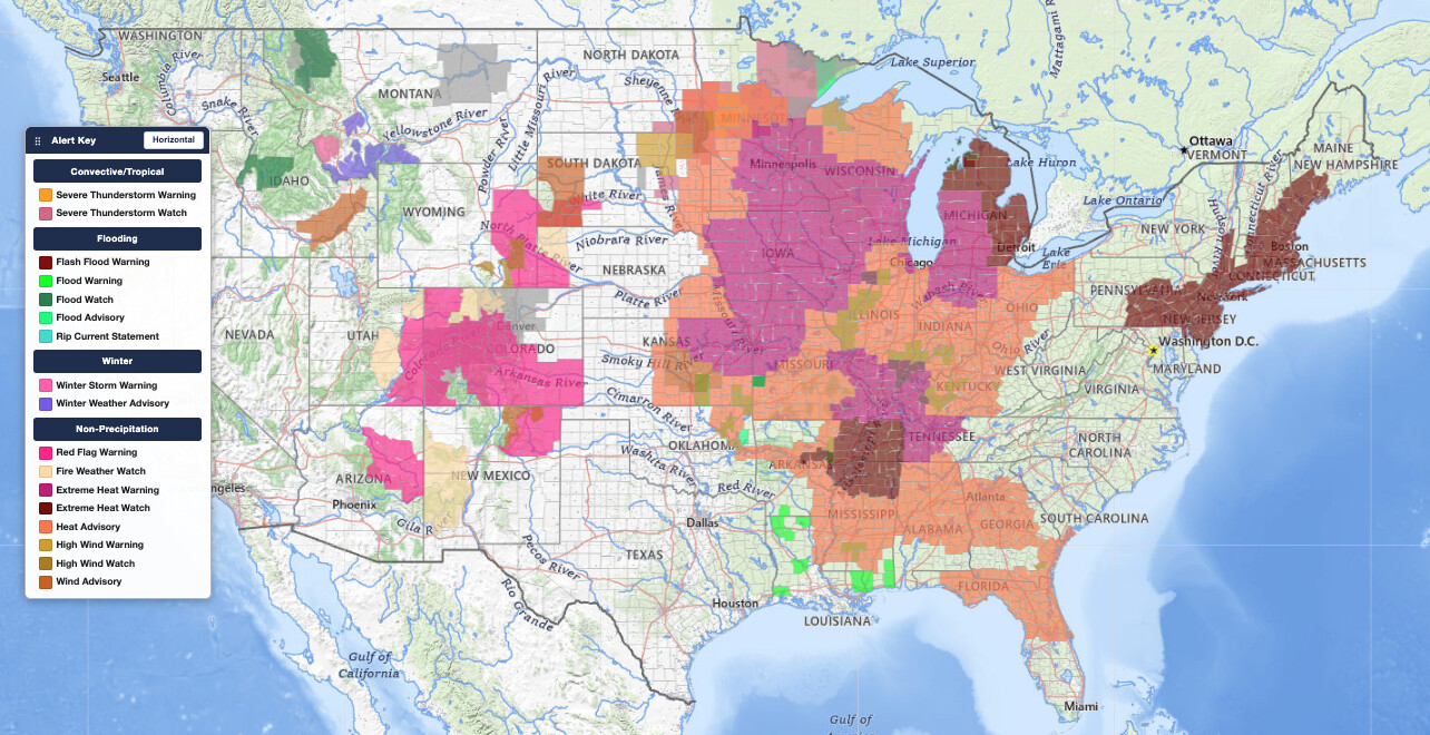
Key points:
- Extreme Heat Warnings cover the central U.S. now, from the Dakotas and Nebraska east through Minnesota, Iowa, Wisconsin, and Illinois.
- The heat shifts and expands east through the week, with Extreme Heat Watches for the Northeast starting Wednesday.
- Heat index values of 105 to 115°F are expected in the hardest-hit areas.
- Overnight lows only in the mid to upper 70s mean little nighttime recovery.
- For the East Coast, the worst heat arrives over the July 4th weekend, with watches around Philadelphia running through Saturday evening.
Where and When: A Dangerous Heat Wave on the Move
This dangerous heat wave is not a single-location event. The ridge driving it expands and drifts east through the week, so the timing differs by region. Click any alert below to see the live details and the counties covered on iAlert.
Extreme Heat Warnings (Central U.S., now through this week):
| Area | In effect until | Alert |
|---|---|---|
| Sioux Falls, SD | Monday night | View alert → |
| Minneapolis/St. Paul, MN | Monday night | View alert → |
| Duluth, MN | Monday night | View alert → |
| Omaha / SW Iowa | Monday evening | View alert → |
| Des Moines, IA | Tuesday 9 PM | View alert → |
| La Crosse, WI | Tuesday 9 PM | View alert → |
| Green Bay, WI | Tuesday 7 PM | View alert → |
| Milwaukee, WI | Tuesday 7 PM | View alert → |
| Chicago, IL | Wednesday 10 PM | View alert → |
| Quad Cities, IA/IL | Wednesday 10 PM | View alert → |
| Grand Rapids, MI | Thursday 8 PM | View alert → |
| Northern Indiana | Thursday 8 PM | View alert → |
| Nashville, TN | Thursday 8 PM | View alert → |
| Kansas City, MO | Friday 9 PM | View alert → |
| Topeka, KS | Friday 9 PM | View alert → |
| St. Louis, MO | Friday 10 PM | View alert → |
| Paducah, KY | Friday 8 PM | View alert → |
Extreme Heat Watches (East, midweek into the holiday weekend):
| Area | In effect | Alert |
|---|---|---|
| Detroit, MI | Tuesday through Thursday | View alert → |
| Northern Michigan | Tuesday through Thursday | View alert → |
| Albany, NY | Wednesday through Friday | View alert → |
| Boston, MA | Wednesday through Friday | View alert → |
| Portland, ME | Wednesday through Friday | View alert → |
| New York City / Long Island | Wednesday through Friday | View alert → |
| Central Pennsylvania | Wednesday through Friday | View alert → |
| Philadelphia area | Through Saturday evening, July 4 | View alert → |
The pattern is clear: the central U.S. bakes first, the Great Lakes and the Mississippi and Ohio valleys hold the longest, and the East Coast heats up last, right through the holiday.
Warning vs Watch vs Advisory: What the NWS Terms Mean
The National Weather Service uses three heat products, in increasing order of concern:
- Heat Advisory: dangerous heat is happening or imminent. Take precautions.
- Extreme Heat Watch: conditions favor dangerous heat in the next day or two. This is the “get ready” signal, which is why the Northeast is under watches now for midweek.
- Extreme Heat Warning: dangerous heat is happening or about to happen. This is the highest alert and is in effect across the central U.S. today.
These replace the older “Excessive Heat” labels. Alongside them, the NWS HeatRisk index rates each day from Minor to Extreme based on how unusual, widespread, and prolonged the heat is, and on its likely health impact.
Meteorologist’s Take
A dangerous heat wave of this footprint is the signature of a strong, stalled upper-level ridge. Beneath it, sinking air compresses and warms, skies stay mostly clear, and daytime heating goes unchecked. As the ridge builds and nudges east through the week, the core of the heat travels with it, which is why the central U.S. peaks first and the East Coast peaks over the holiday weekend.
The danger in a multi-day stretch is heat-stress accumulation. With overnight lows holding in the mid to upper 70s, the body never fully cools between afternoons. Each successive day starts from a hotter baseline, the ability to thermoregulate degrades, and heat-related emergency calls typically climb late in the event rather than on day one.
The Fourth of July compounds the risk: outdoor cookouts, parades, fireworks crowds, and travel all peak on the single hottest day for the East Coast. If you are in the I-95 corridor, plan holiday activity around the heat, not in spite of it.
You can track exactly which counties are under heat warnings, watches, and advisories in real time on iAlert’s active weather alerts map, which pulls live National Weather Service data.
How to Stay Safe
The National Weather Service heat safety guidelines come down to a few essentials:
- Get to air conditioning. If home isn’t cooled, plan to spend midday and afternoon at a public cooling center, library, or mall. Fans alone are not enough when overnight lows stay in the 70s.
- Hydrate continuously. Drink water through the day even before you feel thirsty. Thirst lags actual dehydration in heat.
- Check on the vulnerable daily. Elderly neighbors, young children, and anyone with a chronic condition. Never leave children or pets in parked vehicles.
- Shift outdoor activity to early morning and take frequent shaded breaks. For the holiday weekend on the East Coast, this is the difference between a safe cookout and a 911 call.
- Know the signs. Heat exhaustion: heavy sweating, cool pale skin, fast weak pulse, nausea, dizziness. Heat stroke: hot dry skin, rapid strong pulse, confusion or unconsciousness. Heat stroke is a life-threatening emergency, call 911 immediately.
For a forecast tailored to your exact location, check your iAlert local forecast through the week to see how the heat builds in your area and when relief arrives.
Don’t get caught off guard as this dangerous heat wave crosses the country. Sign up for iAlert weather alerts and notifications to get real-time heat warnings, watches, and advisories sent straight to your phone.
Source: National Weather Service active alerts, accessed June 29, 2026.


