
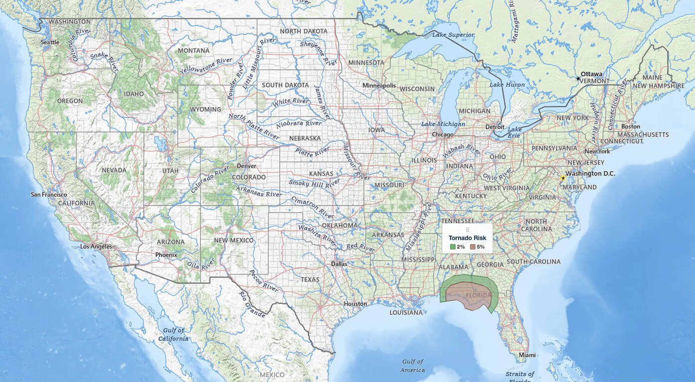
Florida Panhandle tornado risk headlines the NOAA Storm Prediction Center Day 1 Convective Outlook valid Friday, October 9, 2026, issued 05:37 UTC (1:37 am EDT / 12:37 am CDT). It places a Slight Risk, level 2 of 5, across parts of the Florida Panhandle, southeast Alabama and southwest Georgia, where thunderstorms associated with Hurricane Isaias will have potential to produce tornadoes from this afternoon into the overnight period. Pensacola, Panama City, Tallahassee and Dothan all sit inside that Slight Risk.
Key points:
- SPC Slight Risk, level 2 of 5, for Friday, October 9, 2026.
- 5% tornado probability covers 20,634 sq mi and about 1.77 million people.
- Pensacola, Panama City, Tallahassee and Dothan are inside the 5% area.
- Florida Panhandle tornado risk runs this afternoon into the overnight hours.
- Isaias had 110 mph winds at 4 am CDT, with landfall tonight or early Saturday.
Get Severe Weather Alerts for Your Location
When any NWS watch, warning, or advisory is issued for your area, iAlert sends you an immediate notification by email, text message, or phone call, 24 hours a day, 7 days a week.
Sign Up for Severe Weather Alerts →Where the Florida Panhandle tornado risk is focused
The Slight Risk outline matches the 5% tornado probability area exactly, so the tornado threat alone earned the category. That area runs along the coast from Pensacola and Fort Walton Beach through Panama City and Apalachicola to Tallahassee, and inland to Dothan and Enterprise in southeast Alabama and Thomasville in southwest Georgia. SPC puts it at 20,634 square miles and 1,765,353 people. A 5% tornado probability means a 5% chance of a tornado within 25 miles of any point; it is not a measure of how strong a tornado would be.
A Marginal Risk, level 1 of 5, wraps around the Slight Risk and matches the 2% tornado ring. It reaches Gulf Shores, Alabama, and Albany, Valdosta, Tifton and Moultrie in southwest Georgia, covering 17,009 square miles and 901,736 people. You can read more about the five tiers in the iAlert guide to SPC outlook risk categories.
General Thunderstorms, for non-severe storms, cover three separate areas: the rest of Florida and coastal Georgia, including Mobile, Montgomery, Jacksonville, Tampa, Orlando, Fort Myers, Miami and Savannah; a Midwest area including Chicago, Milwaukee, Springfield, Illinois, and Lafayette, Indiana; and a Southwest area including Phoenix, Tucson, Flagstaff, Albuquerque, Grand Junction and Salt Lake City. None of those cities carry a severe risk level today.
Timing of the Florida Panhandle tornado risk
The outlook period runs 12z to 12z, beginning at 8:00 am EDT / 7:00 am CDT. As the center of Isaias approaches the Gulf Coast this afternoon, rainbands will spread across the Florida Panhandle, and thunderstorms will develop within those bands and move inland. The National Hurricane Center 4 am CDT advisory says a tornado risk will begin late this afternoon and continue tonight in coastal Alabama, the Florida Panhandle and far southwest Georgia.
SPC expects the tornado threat to persist into the overnight period as the rainbands move northward into southern Alabama and southwest Georgia. NHC adds that the tornado threat will continue Saturday across parts of eastern Alabama, the Florida Panhandle, Georgia and the Carolinas. Tornadoes after dark are harder to see and easier to sleep through, so the overnight hours deserve the most attention.
SPC drew no hail or damaging wind probability areas anywhere today. That covers thunderstorm hazards only. Hurricane-force winds from Isaias itself are a separate threat handled by NHC, which has a Hurricane Warning in effect from Ocean Springs, Mississippi, to the Bay/Gulf County line in Florida.
Hurricane Isaias status
At 4 am CDT, NHC placed the eye of Isaias about 200 miles south-southeast of the mouth of the Mississippi River, moving north-northeast near 15 mph with maximum sustained winds near 110 mph, a Category 2 hurricane. NHC says Isaias is likely to become a major hurricane this morning, with slight weakening expected before landfall within the warning area tonight or early Saturday. The SPC outlook, written about three hours earlier, referenced a landfall near Pensacola early this evening.
Beyond tornadoes, NHC forecasts storm surge of 5 to 7 feet from Dauphin Island, Alabama, to Indian Pass, Florida, and rainfall of 4 to 8 inches across southern Alabama, the Florida Panhandle and Big Bend, and southwest Georgia, with localized totals up to 15 inches.
Meteorologist’s take
The ingredients the SPC describes are classic for tropical cyclone tornadoes. The airmass ahead of the rainbands is forecast to be very moist and unstable, with surface dewpoints in the mid to upper 70s contributing to moderate instability and MLCAPE likely peaking in the 1500 to 2000 J/kg range along parts of the coast. That is plenty of fuel for storms embedded in a landfalling hurricane’s circulation.
The second ingredient is low-level wind shear. RAP forecast soundings in the Florida Panhandle to the east of the center of Isaias early this evening suggest 0-3 km storm-relative helicity increasing to around 200 m2/s2. Storm-relative helicity measures how much the wind turns and strengthens with height relative to a moving storm, and SPC says values in that range will support rotating storms with potential to produce tornadoes.
The location matters too. The Panhandle sits east of the forecast track, the side of a landfalling hurricane where tornadoes are most common. Tropical cyclone tornadoes are often small, shallow and fast moving, radar rotation can be subtle, and warning lead times are frequently short. The Tropical cyclone tornadoes are often small, shallow and fast moving, radar rotation can be subtle, and warning lead times are frequently short. The Florida Panhandle tornado risk calls for a watch-and-react posture all afternoon and through the night rather than waiting for a single obvious line of storms.
How to stay safe during the Florida Panhandle tornado risk
Tornado safety during a landfalling hurricane comes down to warning reception and a short, rehearsed plan. Because the threat extends into the overnight hours, make sure something will wake you up.
- Set up at least two ways to receive warnings overnight, including a phone alert that overrides silent mode and a NOAA Weather Radio.
- Pick your shelter now: the lowest floor, an interior room or hallway, away from windows.
- If you live in a mobile or manufactured home, identify a sturdier building you can reach quickly and go before storms arrive.
- Keep shoes, a flashlight and a charged phone next to the bed.
- Act on a tornado warning immediately; rain-wrapped tropical tornadoes are rarely visible.
- Follow evacuation and other instructions from local officials for storm surge and hurricane winds.
Track storms in real time with live radar and alerts, check active weather alerts for your county, and follow the system on the iAlert hurricane tracker. Residents across the Florida Panhandle tornado risk area should treat any warning tonight as a reason to move to shelter without hesitation.
Florida Panhandle tornado risk FAQ
Where is the highest risk today?
The Slight Risk, level 2 of 5, covers parts of the Florida Panhandle, southeast Alabama and southwest Georgia, including Pensacola, Panama City, Tallahassee and Dothan. A Marginal Risk extends into Gulf Shores and southwest Georgia cities such as Albany and Valdosta.
Is there a tornado risk?
Yes. The Florida Panhandle tornado risk is level 2 of 5: SPC gives the Slight Risk area a 5% tornado probability, meaning a 5% chance of a tornado within 25 miles of a point, with a 2% probability in the surrounding Marginal Risk. Thunderstorms in Isaias rainbands will have potential to produce tornadoes.
When do storms arrive?
The Florida Panhandle tornado risk starts this afternoon, as rainbands spread across the Florida Panhandle ahead of landfall. NHC expects the tornado risk to begin late this afternoon and continue tonight, and SPC expects it to persist overnight as the bands move north into southern Alabama and southwest Georgia.
Is large hail or damaging wind in the outlook?
SPC drew no hail or damaging thunderstorm wind areas today. Hurricane-force winds from Isaias are a separate hazard covered by the NHC Hurricane Warning from Ocean Springs, Mississippi, to the Bay/Gulf County line in Florida.
Sources:
- NOAA Storm Prediction Center, Day 1 Convective Outlook, issued 05:37 UTC (1:37 am EDT / 12:37 am CDT), October 9, 2026
- National Hurricane Center, Hurricane Isaias Advisory 11, 4:00 am CDT, October 9, 2026
- National Hurricane Center, Hurricane Isaias Discussion 11, 4:00 am CDT, October 9, 2026
Get Severe Weather Alerts for Your Location
When any NWS watch, warning, or advisory is issued for your area, iAlert sends you an immediate notification by email, text message, or phone call, 24 hours a day, 7 days a week.
Sign Up for Severe Weather Alerts →

