
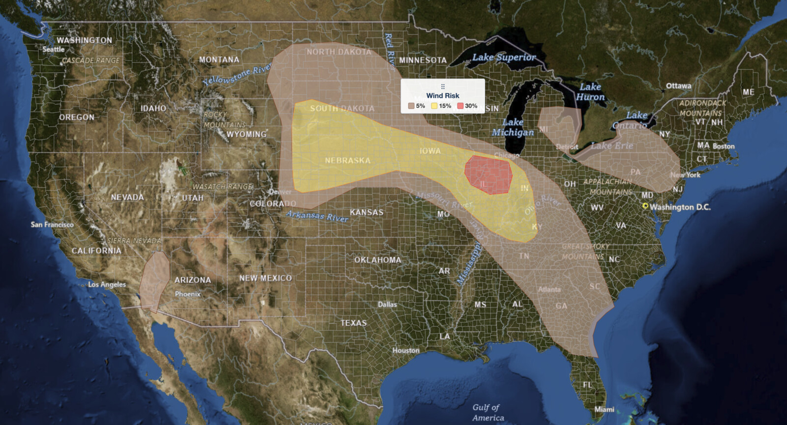
Plains severe thunderstorms are the top weather story for Wednesday, August 12, 2026. The NOAA Storm Prediction Center has issued a Slight Risk, the second of five severe categories, from the central and northern High Plains through the mid Mississippi Valley into the lower Ohio Valley. Inside it the SPC has drawn a 30% damaging wind probability over central and eastern Illinois, the highest severe wind probability in the country today.
Key points:
- Slight Risk (level 2 of 5) runs from western South Dakota and Nebraska across Iowa into Illinois, Indiana, and northern Kentucky.
- A 30% damaging wind probability covers central and eastern Illinois plus Davenport, Iowa, the highest wind probability drawn nationwide today.
- Damaging wind is the lead hazard with today’s plains severe thunderstorms, and a 15% wind probability covers the rest of the Slight Risk.
- A 15% large hail probability sits over the western High Plains near Scottsbluff and Chadron, Nebraska, and Rapid City, South Dakota.
- A 2% tornado probability covers Indianapolis, Louisville, St. Louis, Peoria, and Champaign. No hatched significant-severe area is drawn today.
- Storm clusters were already moving from eastern Iowa into northern Illinois at issuance; High Plains storms develop late afternoon into evening.
Where Plains Severe Thunderstorms Are Most Dangerous Today
Today’s plains severe thunderstorms Slight Risk spans two connected corridors. The eastern one runs through the mid Mississippi Valley and lower Ohio Valley, taking in Des Moines, Cedar Rapids, Davenport, Waterloo, and Council Bluffs in Iowa; Peoria, Springfield, Champaign, Bloomington, and Joliet in Illinois; Indianapolis, Lafayette, and Terre Haute in Indiana; plus St. Louis and Louisville. The western one covers the High Plains, where Omaha, Grand Island, North Platte, Rapid City, and Pierre all sit inside the polygon.
Damaging wind is what earns the category. The Slight Risk polygon and the combined 15% and 30% wind areas are all but identical, matching to within a fraction of a percent of their area, so the wind threat alone lifted this corridor to level 2 of 5. The 30% core sits over central and eastern Illinois and reaches into far eastern Iowa, covering Peoria, Champaign, Bloomington, Decatur, Danville, Galesburg, Kankakee, Joliet, and Davenport.
Everywhere else inside the risk area carries a 15% damaging wind probability, meaning a 15% chance of a damaging wind report within 25 miles of a given point. That covers Omaha, Des Moines, Sioux City, Indianapolis, Terre Haute, Evansville, Louisville, and St. Louis.
Large hail is the second hazard with today’s plains severe thunderstorms, and it peaks well west of the wind threat. A 15% large hail probability covers Scottsbluff, Chadron, Alliance, and Sidney in Nebraska, Rapid City in South Dakota, and Sterling in northeast Colorado. A wider 5% probability runs from Grand Island and Sioux City northward through the Dakotas to Fargo and Bismarck, with a second 5% area over Illinois and Indiana that takes in Chicago, Rockford, Indianapolis, and St. Louis.
A 2% tornado probability applies to Indianapolis, Louisville, St. Louis, Springfield, Peoria, Champaign, Evansville, Lafayette, and Terre Haute. Two percent is low in absolute terms, but worth knowing given storms were already in progress there at issuance. SPC uses a five-tier system to rate severe weather potential; for the full breakdown see the iAlert guide to SPC outlook risk categories.
A Marginal Risk, the lowest of the five tiers, covers three separate areas around the plains severe thunderstorms corridor. The largest wraps the Slight Risk, running north through the Dakotas and south and east through Missouri, Tennessee, Georgia, and the Carolinas, taking in Chicago, Rockford, Cincinnati, Nashville, Atlanta, and Charlotte. A second runs from lower Michigan across Lake Erie into Pennsylvania, New York, and New Jersey. A third sits over the lower Colorado River Valley near Yuma, Arizona.
In that Great Lakes and Northeast area, Detroit, Cleveland, Buffalo, Rochester, Scranton, and Erie carry both a 5% damaging wind and a 5% large hail probability. Philadelphia, Harrisburg, Allentown, and Trenton carry the 5% wind only.
Meteorologist’s Take on Today’s Plains Severe Thunderstorms
The eastern half of today’s plains severe thunderstorms setup was already underway at issuance. Radar and satellite imagery at 12:36 UTC (8:36 a.m. EDT / 7:36 a.m. CDT) showed several storm clusters from Iowa into the Ohio Valley, the most notable over far eastern Iowa moving into central and northern Illinois.
The air mass downstream is very moist and extremely unstable. The 12 UTC Davenport, Iowa sounding measured 4,300 joules per kilogram of mixed-layer CAPE, an unusually large reservoir of storm fuel for mid-August. That air mass sits near the terminus of a 35-knot west-southwesterly low-level jet over northern Missouri. The SPC expects the combination to drive a gradual intensification of storms across Illinois through the morning, with a risk of scattered severe gusts and wind damage.
Two things temper the eastern threat. The SPC notes considerable uncertainty about how additional storm clusters evolve across the Midwest this afternoon. Outflow from the morning storms over eastern Indiana and central Kentucky will also likely hold down the severe risk farther east across parts of the Ohio Valley. Even so, a moist and destabilizing boundary layer keeps scattered wind damage and isolated large hail in play with the stronger storms into the evening.
On the Plains, east and southeasterly low-level flow holds modest moisture across the Dakotas, increasing southward across Nebraska into northern Kansas. Near-60-degree dewpoints should spread west into eastern Colorado, Wyoming, and Montana beneath steep lapse rates. Ample heating gives moderate buoyancy and more than 30 knots of effective shear, enough to organize the scattered storms expected to develop later this afternoon. Initial cells carry the large hail and severe gust threat.
Some clustering may occur during the evening, but confidence remains low on which corridors the severe threat will focus. That is the honest read on the western half of today’s plains severe thunderstorms: the ingredients are in place, the placement is not.
The Great Lakes into Northeast threat runs on different ingredients. A belt of stronger northwesterly flow aloft extends from lower Michigan into New York and Pennsylvania, and vertically veering wind profiles give more than 35 knots of effective shear with elongated hodographs. That is more shear than the Plains have today. What holds the area to a Marginal Risk is thermodynamics: midlevel lapse rates stay modest and MLCAPE reaches only about 1,000 to 1,500 joules per kilogram, so storms there carry damaging gusts and marginally severe hail.
Two lower-end areas round out the day. Across the Tennessee Valley and Southeast, midday storms in a very moist, strongly unstable air mass could produce water-loaded downdrafts capable of wind damage, helped by precipitable water near 2 inches. Over the lower Colorado River Valley, widely scattered storms near a weak upper trough may produce isolated severe gusts, which is what put Yuma in a Marginal Risk.
How to Stay Safe During Plains Severe Thunderstorms
Damaging wind is the lead hazard across today’s plains severe thunderstorms corridor, and the 30% area over Illinois is where it is most likely. Gusts reaching severe criteria start at 58 mph, enough to bring down limbs and power lines. Move vehicles under cover, bring in anything loose, and track cells on iAlert live radar and alerts.
Large hail is the bigger concern on the High Plains. Hail at severe criteria is at least one inch in diameter, enough to dent vehicles and crack windshields. Garage a car if you have the option, and do not wait out a hailstorm in the open.
If a Severe Thunderstorm Warning is issued for your county, move to an interior room on the lowest floor, away from windows. Anyone in the 2% tornado probability zone should know their shelter spot in advance. Check active weather alerts for your area and keep a weather app or NOAA Weather Radio within reach, because plains severe thunderstorms are expected to continue into the evening.
Plains Severe Thunderstorms FAQ
Where is the highest risk from today’s plains severe thunderstorms?
The 30% damaging wind area over central and eastern Illinois, covering Peoria, Champaign, Bloomington, Decatur, Danville, Galesburg, Kankakee, and Joliet, plus Davenport, Iowa. It is the highest severe wind probability the SPC has drawn anywhere in the country today.
How large could hail get in today’s plains severe thunderstorms?
The 15% large hail probability sits over the western High Plains near Scottsbluff and Chadron, Nebraska, Rapid City, South Dakota, and Sterling, Colorado. The outlook states no maximum diameter and draws no hatched significant-severe area, so expect hail at or above the one-inch severe threshold rather than a giant-hail event.
Is there a tornado threat with today’s plains severe thunderstorms?
Yes, but a limited one. The SPC shows a 2% tornado probability covering Indianapolis, Louisville, St. Louis, Springfield, Peoria, Champaign, Evansville, Lafayette, and Terre Haute. That is the lowest tornado tier the SPC issues, and no hatched area is drawn, but storms already in progress make a shelter plan worth having.
When will the worst of today’s plains severe thunderstorms arrive?
Storms across Iowa and Illinois were already active at the 12:36 UTC issuance and should intensify through the morning. Storms on the High Plains develop later in the afternoon and evening and may cluster after dark. The outlook period for today’s plains severe thunderstorms runs through 12 UTC Thursday, August 13.
Why are today’s plains severe thunderstorms only a Slight Risk with a 30% wind probability?
A 30% damaging wind probability normally corresponds to an Enhanced Risk, level 3 of 5. The SPC held the categorical outlook at Slight Risk in this issuance while drawing the 30% wind area over Illinois. Watch for a possible upgrade in the next update if the Illinois cluster holds together through the morning.
Sources:
Get Severe Weather Alerts for Your Location
When any NWS watch, warning, or advisory is issued for your area, iAlert sends you an immediate notification by email, text message, or phone call, 24 hours a day, 7 days a week.
Sign Up for Severe Weather Alerts →

