
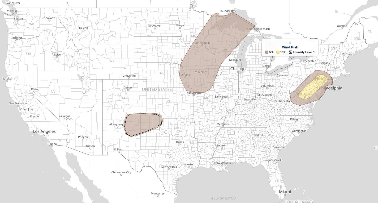
Mid-Atlantic severe thunderstorms are the primary concern in today’s Storm Prediction Center Day 1 Convective Outlook, valid August 7, 2026. The NOAA Storm Prediction Center has placed the I-95 corridor from Washington DC through Baltimore and Philadelphia to New York City in a Slight Risk, the second of five severe categories (level 2 of 5). Isolated to scattered storms capable of producing damaging winds are expected to fire this afternoon and cluster as they push northeast toward the coast.
Key points:
- Mid-Atlantic severe thunderstorms fall under a Slight Risk (level 2 of 5) for August 7, 2026, running from the Washington DC metro northeast through Baltimore, Wilmington, Philadelphia, Trenton, and Newark to New York City.
- Damaging wind is the main hazard. The SPC 15% damaging wind area covers exactly the same ground as the Slight Risk.
- There is no hail probability in the Mid-Atlantic. The SPC 5% hail area sits over the Upper Midwest, from Omaha and Des Moines north to Minneapolis, Duluth, and Wausau.
- Storms are expected to develop in the 18–20 UTC window, roughly 2 to 4 p.m. EDT, and cluster around peak heating.
- Harrisburg, Scranton, Dover, Atlantic City, Winchester, Poughkeepsie, and Bridgeport sit just outside, in the surrounding Marginal Risk (level 1 of 5).
Where Mid-Atlantic Severe Thunderstorms Are Expected Today
The Slight Risk for today’s Mid-Atlantic severe thunderstorms is a narrow southwest to northeast corridor drawn almost directly along Interstate 95, not a broad blanket over the region. It begins over the Washington DC metro, taking in Arlington, Alexandria, Manassas, Leesburg, and Dulles, then runs through Frederick, Annapolis, and Baltimore, crosses northern Delaware at Wilmington, and covers the Philadelphia metro including Camden, Chester, and Norristown.
From there it continues through Trenton, Princeton, and New Brunswick into northern New Jersey at Morristown, Paterson, and Newark, then ends over New York City and its northern suburbs at Yonkers, White Plains, and Nyack, reaching into southwest Connecticut near Stamford. The corridor also widens west across southeast Pennsylvania to cover York, Hershey, Lancaster, Reading, Allentown, Bethlehem, and Easton.
That footprint is the story. Today’s Mid-Atlantic severe thunderstorms are aimed at one of the densest population corridors in the country, so a Slight Risk here puts far more people under a wind threat than the same category would across open terrain. SPC uses a five-tier system to communicate severe weather potential, and you can read a full breakdown of each category in the iAlert SPC outlook risk categories explainer.
Several cities sit just outside the Slight Risk, inside the surrounding Marginal Risk (level 1 of 5), where isolated severe storms are still possible: Harrisburg, Carlisle, and Scranton in Pennsylvania; Dover, Salisbury, and Atlantic City on the coastal plain; Winchester and Fredericksburg in Virginia; and Poughkeepsie, Danbury, and Bridgeport to the northeast. Do not read the outlook boundary as a wall.
Farther west, the SPC highlights more isolated severe chances from the mid-Missouri Valley into the Lake Superior region and across the southern High Plains and central Plains. Those areas are tied to a Canadian shortwave and to localized outflow boundaries rather than the feature driving the Mid-Atlantic severe thunderstorms threat. Richmond, Norfolk, Pittsburgh, Charleston, Albany, and Hartford fall in the General Thunderstorm area only.
Meteorologist’s Take
The engine behind today’s Mid-Atlantic severe thunderstorms is a weak upper-level perturbation the SPC analyzes over the mid-Mississippi Valley, one of several embedded in a low-amplitude trough over the central states. That feature reaches the central Appalachians and the Mid-Atlantic by mid-afternoon, supplying just enough large-scale lift to set off convection. The distinction matters: the Appalachians are where the trigger arrives, but the risk area is drawn downstream over the coastal plain, because that is where storms mature.
The air mass it moves into is seasonally moist, with surface dewpoints in the low to mid 70s. Strong daytime heating pushes mixed-layer CAPE, a measure of how much energy is available to rising air parcels, to roughly 1,000 to 2,000 joules per kilogram with minimal capping by early afternoon. That is a solid energy environment even though mid-level lapse rates are, in the SPC’s own word, meager. Heat and moisture carry this setup, not a steep temperature profile aloft.
The storm mode expected with today’s Mid-Atlantic severe thunderstorms is loosely organized clusters and short line segments rather than discrete supercells. Winds through the lowest 2 to 3 kilometers stay modest, but steep low-level lapse rates and around 25 knots of effective bulk shear are enough to support upscale growth as individual cells merge. That merging is what produces embedded swaths of damaging wind rather than isolated pulse downbursts, and CAM guidance shows a reasonably strong signal for it as storms spread northeast around peak heating.
One detail about today’s Mid-Atlantic severe thunderstorms deserves attention. The Slight Risk polygon and the 15% damaging wind polygon are geometrically identical, the same shape down to the vertex. That is the SPC saying the wind threat alone earned the upgrade, with no tornado or hail probability riding along inside it. The message is clean: this is a wind event, full stop.
A separate and more pronounced shortwave trough moving out of central Canada into the northern Plains, along with its surface low and trailing cold front, drives the isolated severe threat from the mid-Missouri Valley into the Lake Superior region as that system tracks toward the Great Lakes tonight. That corridor is where the 5% hail probability lives, with 30 to 35 knot mid-level flow supporting a few organized cells. Overnight, elevated storms across northern Nebraska and southern South Dakota may turn severe as a low-level jet strengthens.
How to Stay Safe During Mid-Atlantic Severe Thunderstorms
Because the hazard in today’s Mid-Atlantic severe thunderstorms is damaging wind and low risk of tornadoes, the action that matters is getting indoors and away from windows before storms arrive. Thunderstorm outflow can drop trees and power lines with very little warning. Do not wait until lightning is overhead to move inside.
Track live radar and active alerts on iAlert through the afternoon so you know exactly when a cluster of Mid-Atlantic severe thunderstorms is approaching, whether you are in Washington, Baltimore, Philadelphia, or the New York City metro. Timing runs roughly southwest to northeast: storms fire first near the Appalachian foothills and the DC area in the early to mid afternoon, then reach the northern half of the corridor later in the day.
If a Severe Thunderstorm Warning is issued for your county, move to an interior room on the lowest floor of a sturdy building. Bring in or secure outdoor furniture, umbrellas, and anything else a gust can turn into a projectile, and do it before the sky darkens rather than during the storm. Avoid corded phones and plumbing while lightning is active, and stay off the road if you can, because a downed tree across a lane is the most common way Mid-Atlantic severe thunderstorms turn dangerous.
Mid-Atlantic Severe Thunderstorms FAQ
Which cities are in the Slight Risk today?
The Slight Risk corridor for today’s Mid-Atlantic severe thunderstorms includes Washington DC, Arlington, Leesburg, Frederick, Annapolis, Baltimore, Wilmington, York, Lancaster, Reading, Allentown, Philadelphia, Camden, Trenton, Princeton, Newark, Paterson, New York City, White Plains, and Stamford. Boundaries shift with each SPC update, so treat the edge as approximate.
Are New York City and Philadelphia in the Mid-Atlantic severe thunderstorms risk area?
Yes. Both sit inside the Slight Risk and inside the 15% damaging wind area, not on the edge of it. The corridor runs from the Washington DC metro to the New York City metro, which is what makes this outlook worth attention despite the modest category.
How strong could the wind gusts be?
The SPC assigns a 15% damaging wind probability to the Mid-Atlantic severe thunderstorms corridor. That figure is the chance of a damaging wind report within 25 miles of any point, not a specific gust speed. The discussion does not list an explicit peak gust value, and the higher-end conditional intensity area today sits over the southern High Plains, not the Mid-Atlantic.
Is there a tornado threat with these storms?
No. The SPC Day 1 tornado outlook reads “less than 2% all areas,” meaning no tornado probability is drawn anywhere in the country today. Damaging wind is the only hazard outlooked for the Mid-Atlantic.
Is large hail a concern in the Mid-Atlantic today?
No. The SPC 5% hail probability does not touch the Mid-Atlantic at all. It covers the Upper Midwest, including Omaha, Des Moines, Sioux City, Minneapolis, Duluth, La Crosse, and Wausau, where stronger mid-level flow supports a few organized hail-producing cells. Today’s Mid-Atlantic severe thunderstorms are a wind-only threat.
When will storms develop and how long will they last?
The SPC expects Mid-Atlantic severe thunderstorms to develop during the 18–20 UTC window, roughly 2 to 4 p.m. EDT, with clustering and upscale growth as storms spread northeast toward the I-95 corridor around peak heating. The threat runs through the late afternoon and into the evening as the activity reaches the coast.
Sources:
Get Severe Weather Alerts for Your Location
When any NWS watch, warning, or advisory is issued for your area, iAlert sends you an immediate notification by email, text message, or phone call, 24 hours a day, 7 days a week.
Sign Up for Severe Weather Alerts →

