
Ozarks severe thunderstorms are forecast to develop this afternoon and evening across northeast Oklahoma, southeast Kansas, and the Missouri Ozarks on August 6, 2026, as the NOAA Storm Prediction Center has issued a Slight Risk, the second of five severe categories (level 2 of 5). SPC uses a five-tier system to communicate severe weather potential; see SPC outlook risk categories explained for a full breakdown. Damaging wind gusts are the primary named threat, with the hazard window extending into the mid to late evening hours.
Key points:
- Slight Risk (level 2 of 5) for northeast Oklahoma and southeast Kansas into the Missouri Ozarks.
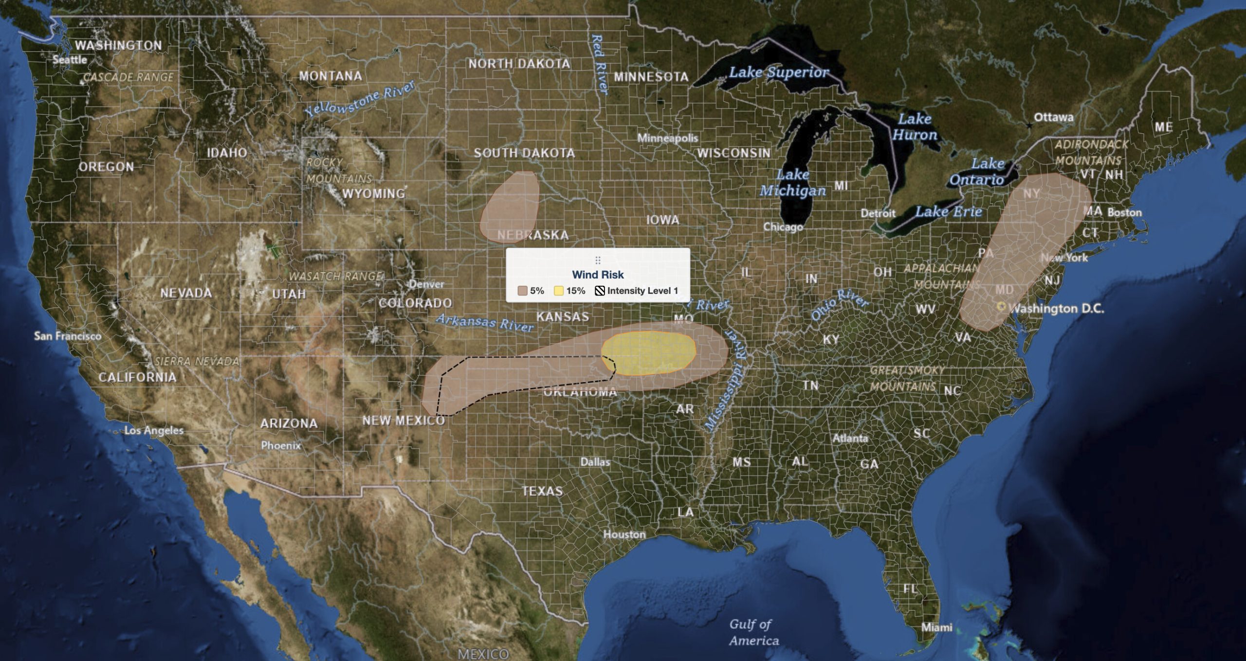
- SPC calls this a threat “capable primarily of a severe-wind threat,” with a 15% damaging wind probability in the core and 5% surrounding it.
- Ozarks severe thunderstorms develop this afternoon near a residual front, with multicell clusters evolving during the early evening.
- The 15% wind area sits over southeast Kansas and southwest to south-central Missouri, clipping far northeast Oklahoma.
- A separate isolated wind-damage threat runs from the Mid-Atlantic coast north through New York.
Where Ozarks Severe Thunderstorms Are Most Likely
The focus for today’s activity sits along a residual, quasi-stationary frontal boundary stretching from far northern Oklahoma east-northeastward into south-central Missouri. SPC places the formal Slight Risk across northeast Oklahoma and southeast Kansas into the Missouri Ozarks, with far northwest Arkansas at the southern fringe. Joplin, Missouri, sits near the center of the risk area. The Tulsa, Oklahoma, metro falls along its southwestern edge. Both could see severe weather as storms fire near the front during the afternoon and organize through the evening.
A secondary, lower-end threat exists well to the east. A separate area of thunderstorm development is expected from the Virginia Appalachian foothills northward into southeastern New York and far western New England, where an isolated wind-damage risk is in play. That corridor is separate from the Ozarks severe thunderstorms focus and carries a lower overall hazard level.
Meteorologist’s Take
The energy source driving the Ozarks severe thunderstorms is an upper-level trough pushing eastward toward the mid-Mississippi Valley today. Think of that trough as a dip in the jet stream that focuses lift and stirs up wind profiles in the lower atmosphere. At the surface, the quasi-stationary front acts as a focal line where warm, moist air pools, with surface dewpoints in the 60s to lower 70s degrees Fahrenheit supplying the moisture.
SPC’s morning discussion put 0-to-6-kilometer wind shear at 35 to 40 knots across northern Oklahoma and southern Kansas, with 0-to-3-kilometer lapse rates near 8°C per kilometer. That combination is enough to organize storms and steepen updrafts. Storm clusters were already ongoing this morning across the Mississippi Valley and along the Oklahoma-Kansas border. Model guidance shows moderate destabilization by mid to late afternoon, and SPC expects isolated to widely scattered storms near the residual front, with multicell clusters evolving during the early evening. That mode favors a wind-damage threat over a hail threat, which is why the outlook names severe gusts as the primary concern.
In the Mid-Atlantic and New York corridor, a surface trough from Virginia into southeastern New York serves as the focus. MLCAPE there, a measure of atmospheric instability, is forecast at 1,000 to 2,500 J/kg. Storms building in the Appalachian foothills should move east through the afternoon, with water-loaded downdrafts producing the isolated wind damage. A third area over western Nebraska and southern South Dakota carries an isolated threat of severe gusts and large hail near an axis of low-level moisture, though large-scale ascent there stays weak.
How to Stay Safe During Ozarks Severe Thunderstorms
The hazard named for today’s Ozarks severe thunderstorms is damaging wind gusts. A 15% wind probability means a 15% chance of a severe wind report within 25 miles of any given point, which is a real but not extreme threat. Staying alert and having a plan ready is the right response. Check your local weather forecast this morning and watch for updates through the afternoon, since storm development can be quick once surface heating peaks.
- Wind damage: Bring in or secure outdoor furniture, decorations, and any lightweight objects that could become projectiles in a strong gust before storms arrive.
- Hail: Hail is not the headline threat today, but any severe storm can produce it. If you have covered parking available, use it.
- Shelter: If severe thunderstorm warnings are issued for your county, move indoors immediately and stay away from windows. An interior room on the lowest floor gives the best protection from wind.
- Stay informed: Enable wireless emergency alerts on your phone and monitor active weather alerts through the afternoon and evening, since the threat can persist into the mid to late evening hours.
Ozarks Severe Thunderstorms FAQ
Where is the highest risk for Ozarks severe thunderstorms today?
SPC places the Slight Risk across northeast Oklahoma and southeast Kansas into the Missouri Ozarks, centered along a residual frontal boundary running from northern Oklahoma into south-central Missouri. The 15% wind contour covers southeast Kansas and southwest to south-central Missouri.
How strong could wind gusts get?
SPC assigns a 15% damaging wind probability in the core of the risk area and 5% around it. Those are the odds of a severe wind report within 25 miles of any point, not a forecast gust speed. Severe criteria is 58 mph or higher. The discussion does not name a specific peak gust.
Is large hail expected with today’s Ozarks severe thunderstorms?
Not as a primary threat. SPC describes this event as “capable primarily of a severe-wind threat.” The outlook places its large hail wording over western Nebraska and southern South Dakota, not the Ozarks.
Are tornadoes expected today?
The SPC forecast discussion does not identify a tornado threat for this outlook. The named hazard with today’s Ozarks severe thunderstorms is damaging wind gusts from scattered storms and multicell clusters.
When will the storms arrive and how long will the threat last?
Isolated to widely scattered Ozarks severe thunderstorms are expected to develop during the afternoon near the residual front, with multicell clusters organizing during the early evening. The severe threat could persist into the mid to late evening.
Sources:
Get Severe Weather Alerts for Your Location
When any NWS watch, warning, or advisory is issued for your area, iAlert sends you an immediate notification by email, text message, or phone call, 24 hours a day, 7 days a week.
Sign Up for Severe Weather Alerts →

