
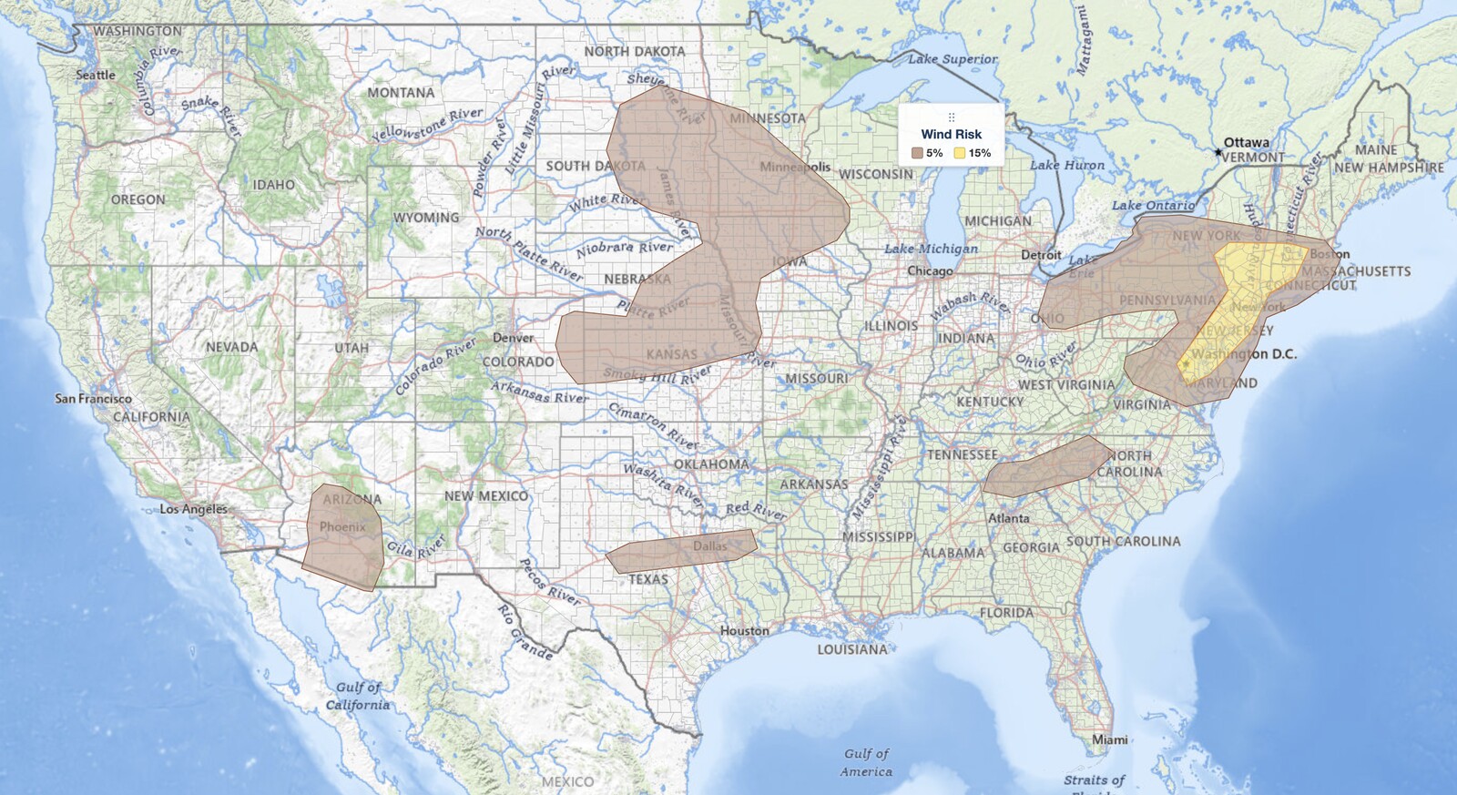
Northeast severe thunderstorms are the top weather concern for August 8, 2026. The NOAA Storm Prediction Center has placed a Slight Risk, the second of five severe categories (level 2 of 5), along a corridor running from the Washington DC and Baltimore area northeast through Philadelphia and New York City to Albany, Hartford, and western Massachusetts. Damaging wind gusts are the hazard, with a 15% damaging wind probability covering that corridor.
Key points:
- A Slight Risk (level 2 of 5) for northeast severe thunderstorms runs from Washington DC and Baltimore northeast through Philadelphia, Trenton, and New York City to Poughkeepsie, Albany, Hartford, Springfield, and Pittsfield.
- Damaging wind is the hazard with today’s northeast severe thunderstorms. The 15% damaging wind area matches the Slight Risk almost exactly.
- Hail is a minor, localized concern. The 5% hail area clips only the southwest end of the corridor near Washington, Baltimore, Wilmington, and Allentown. It does not cover Philadelphia, New York City, Albany, or Hartford.
- Boston, Providence, Worcester, New Haven, Bridgeport, Harrisburg, and Scranton sit just outside the northeast severe thunderstorms Slight Risk, in the Marginal Risk (level 1 of 5).
- Storms should stay isolated rather than forming a solid line, because large-scale lift is weak. The threat is conditional on any storm that does sustain itself.
- Secondary areas: western North Carolina, north Texas, a cluster already moving through Nebraska toward Kansas and Missouri, the Dakotas overnight, and Arizona, where the SPC says it may upgrade Phoenix to a Slight Risk later today.
Where Northeast Severe Thunderstorms Are Most Likely Today
The SPC headline for today’s northeast severe thunderstorms, from the 16:05 UTC Day 1 Convective Outlook, reads “from northern Virginia into southeast New York and western Massachusetts.” The drawn polygon reaches farther than that phrasing suggests. It starts over the Washington DC metro, taking in Arlington, then covers Baltimore, Annapolis, Wilmington, Dover, Philadelphia, Allentown, Trenton, and Newark, runs up through New York City and White Plains, follows the Hudson Valley through Poughkeepsie and Kingston all the way to Albany, and reaches east into Danbury, Hartford, Springfield, and Pittsfield.
The edges of the northeast severe thunderstorms risk area are worth knowing. Boston, Worcester, Providence, New Haven, and Bridgeport are all just outside, in the surrounding Marginal Risk (level 1 of 5), where isolated severe storms are still possible. So are Harrisburg, Scranton, Atlantic City, Islip, and Binghamton. Farther southwest, most of northern Virginia outside the immediate DC suburbs sits in the Marginal Risk too, including Leesburg, Manassas, Winchester, and Fredericksburg. Richmond and Pittsburgh are in the General Thunderstorm area only.
SPC uses a five-tier system to communicate severe weather potential, and you can read how each tier is defined in the iAlert guide to SPC outlook risk categories. A Slight Risk means scattered severe storms are possible, not that a widespread event is expected.
The SPC also extended the Marginal Risk west into northern Ohio beneath the upper trough, where widely scattered storms may produce gusty or damaging winds. Cleveland and Youngstown are inside that extension; Columbus, Toledo, and Cincinnati are not.
Severe Storm Chances Outside the Northeast
Four other areas carry a Marginal Risk today. In western North Carolina, afternoon thunderstorms forming off the mountains near Asheville will track slowly southeastward, and strong daytime heating plus humid air may produce damaging wind gusts in the strongest cores.
Across north Texas, isolated storms are expected to form along an east to west axis this afternoon in a hot, humid air mass, with the strongest slow-moving cells capable of damaging winds. Dallas, Fort Worth, and Abilene are inside that area.
A cluster of strong storms was already ongoing over central Nebraska at outlook time and may persist into the afternoon, tracking southeast toward northeast Kansas and northwest Missouri. A corridor of high CAPE there supports a few storms capable of damaging winds and hail. Overnight, a strengthening southerly low-level jet should fire scattered storms over central North Dakota after midnight, spreading southeast into South Dakota, Minnesota, and Iowa before 12 UTC. Relatively strong vertical shear there will support supercells capable of hail and damaging winds.
Arizona is the one to watch. Full sunshine and sufficient instability will fire storms off the Mogollon Rim this afternoon and evening. Forecast soundings show mid-level moisture increasing as an upper trough passes to the south, which could let that convection survive westward into the lower deserts. With favorable steering flow, strong to severe outflow winds could reach the Phoenix area around 00 UTC. The SPC states it will monitor that scenario for a possible upgrade to a Slight Risk in later outlooks.
Meteorologist’s Take
The engine driving today’s northeast severe thunderstorms is a low-amplitude shortwave trough, a shallow dip in the upper-level wind pattern, sitting over Ohio and tracking east. Morning water vapor satellite imagery confirmed the feature is moving. Ahead of it, a warm and moist air mass has built across the Mid-Atlantic and southern New England, with pockets of mixed-layer CAPE, a measure of how much energy is available to rising air, expected to top 2,000 joules per kilogram later this afternoon. That is enough fuel for vigorous updrafts in anything that gets going.
The catch is that the large-scale lift organizing all of this is weak. The SPC says so plainly, and expects overall storm coverage to be rather isolated. This is not a squall-line day.
What makes it worth a Slight Risk anyway is one conditional ingredient: winds aloft are stronger today than they were yesterday. Any storm that does sustain itself can reach up, tap that stronger flow, and drag it to the surface as a damaging gust. That is a very different forecast from a high-coverage event. Fewer storms, but the ones that mature carry real punch, and they will do it over the most densely populated corridor in the country. That conditional is the entire case for today’s northeast severe thunderstorms.
The northward extension into New York and Massachusetts came from morning model guidance showing higher coverage and confidence in that corridor, which is why the Slight Risk now reaches Albany and the Berkshires rather than stopping at the New York City metro. Note what did not get extended: the 5% hail probability. It clips only the southwestern end of the risk area near Washington, Baltimore, and Allentown, and most of that hail polygon actually lives out over the Plains and Upper Midwest. Treat today’s northeast severe thunderstorms as a wind event with a hail footnote at the southern end.
Overnight in the Dakotas the setup is different in kind. Relatively strong vertical shear there will support discrete supercells rather than loosely organized clusters, which is why that area carries both hail and wind rather than wind alone.
How to Stay Safe During Northeast Severe Thunderstorms
Because damaging wind gusts are the primary hazard in today’s northeast severe thunderstorms, securing loose outdoor items before storms arrive is the highest-value thing you can do. Patio furniture, umbrellas, and lightweight yard objects become projectiles in thunderstorm outflow, and you will not have time once a gust front is on top of you.
The isolated coverage cuts both ways. Most locations in the northeast severe thunderstorms risk area will see nothing today. The ones that do get a storm may get a strong one with very little lead time, so do not read “isolated” as “ignorable.” Check live radar and active weather alerts through the afternoon and evening to track individual cells rather than waiting for a regional forecast to tell you something is coming.
When a Severe Thunderstorm Warning is issued for your area, move indoors and away from windows. If you are driving, pull safely off the road and stay in the vehicle rather than trying to push through a storm core. Covered parking is worth using at the southwest end of the corridor near Washington, Baltimore, and Allentown, where the SPC does carry a 5% hail probability.
Northeast Severe Thunderstorms FAQ
Which cities are in the northeast severe thunderstorms Slight Risk?
The Slight Risk for today’s northeast severe thunderstorms includes Washington DC, Arlington, Baltimore, Annapolis, Wilmington, Dover, Philadelphia, Allentown, Trenton, Newark, New York City, White Plains, Poughkeepsie, Kingston, Albany, Danbury, Hartford, Springfield, and Pittsfield. Boundaries shift with each SPC update, so treat the edge as approximate.
Is Boston in the risk area for northeast severe thunderstorms?
Boston is in the Marginal Risk (level 1 of 5), just outside the Slight Risk, along with Worcester and Providence. Isolated severe storms are still possible there. The Slight Risk reaches western Massachusetts at Springfield and Pittsfield but stops short of the Boston metro.
How strong could wind gusts get in today’s storms?
The SPC assigns a 15% damaging wind probability to the northeast severe thunderstorms corridor. That figure is the chance of a damaging wind report within 25 miles of any point, not a specific gust speed. Today’s discussion does not give a maximum gust figure, unlike yesterday’s outlook, which cited 50 to 65 mph.
Is there a tornado threat with today’s northeast severe thunderstorms?
No. The SPC Day 1 tornado outlook reads “less than 2% all areas,” meaning no tornado probability is drawn anywhere in the country today. Damaging wind is the hazard.
Is hail a concern across the whole risk area?
No. The 5% hail probability touches only the southwestern end of the corridor, near Washington, Baltimore, Annapolis, Wilmington, and Allentown. Philadelphia, New York City, Albany, Hartford, and Springfield have no hail probability drawn. Most of the national 5% hail area is over the Plains and Upper Midwest.
When will storms arrive and how long will the threat last?
Northeast severe thunderstorms are expected to develop through the afternoon of August 8, 2026, across the Mid-Atlantic and southern New England, and continue into the evening. The overnight threat shifts west to the Dakotas, Minnesota, and Iowa, and to Arizona, where severe outflow winds could reach Phoenix around 00 UTC.
Sources:
Get Severe Weather Alerts for Your Location
When any NWS watch, warning, or advisory is issued for your area, iAlert sends you an immediate notification by email, text message, or phone call, 24 hours a day, 7 days a week.
Sign Up for Severe Weather Alerts →

