
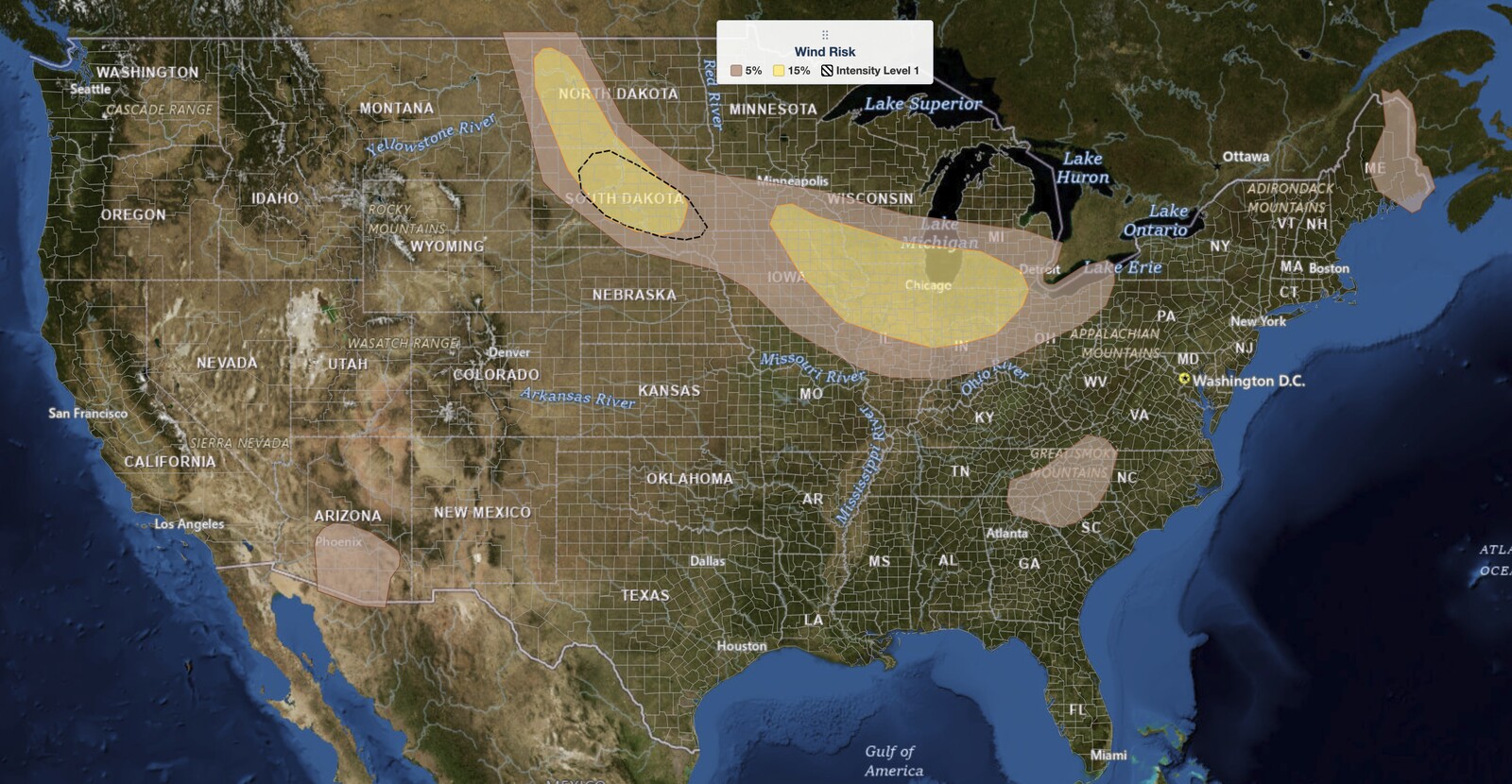
Midwest severe thunderstorms are today’s main weather story, August 9, 2026, with the NOAA Storm Prediction Center drawing a Slight Risk across a corridor that runs from southeast Minnesota and eastern Iowa east through northern Illinois and northern Indiana to the Lake Michigan area. A Slight Risk is the second of five severe categories (level 2 of 5). Chicago, Milwaukee, Madison, and Rockford are inside it. Damaging wind is the primary hazard, with a 15% damaging wind probability across the corridor.
Key points:
- A Slight Risk (level 2 of 5) for midwest severe thunderstorms covers Chicago, Milwaukee, Madison, Rockford, Peoria, Champaign, Davenport, Dubuque, Iowa City, Waterloo, Cedar Rapids, Rochester MN, Gary, South Bend, Fort Wayne, Kalamazoo, and Toledo.
- Damaging wind is the main hazard for midwest severe thunderstorms, at a 15% probability.
- A 2% tornado probability covers a narrower zone than the midwest severe thunderstorms wind area: eastern Iowa, northern Illinois, and northern Indiana, including Chicago, Davenport, Gary, and Fort Wayne. Milwaukee, Madison, Toledo, and Kalamazoo are outside it.
- Hail in the Midwest is a 5% probability, not 15%. The 15% large hail area is in the Dakotas only.
- A second Slight Risk covers the Dakotas, where large hail is the lead hazard. Pierre, Mitchell, Dickinson, and Williston are inside it.
- Minneapolis, St. Paul, Detroit, Grand Rapids, Lansing, Des Moines, and Indianapolis are all outside the Slight Risk.
- SPC says higher probabilities may be needed in later outlooks, depending on how the morning convection evolves.
Where Midwest Severe Thunderstorms Are Most Likely Today
There are two separate Slight Risk areas for midwest severe thunderstorms today, and they carry different lead hazards. The Midwest corridor is the wind story. It begins over southeast Minnesota near Rochester and eastern Iowa at Waterloo, Cedar Rapids, Dubuque, Iowa City, and Davenport, runs east across southern Wisconsin through Madison, Milwaukee, and Kenosha, covers northern Illinois including Rockford, Joliet, Chicago, Peoria, and Champaign, then continues through northern Indiana at Gary, South Bend, Lafayette, and Fort Wayne, clipping southwest Lower Michigan at Kalamazoo and ending right at Toledo.
The boundary matters more than usual with today’s midwest severe thunderstorms, because several large metros people assume are included are not. Minneapolis and St. Paul are not in the Slight Risk. Neither is Detroit, Grand Rapids, Lansing, Ann Arbor, Flint, Saginaw, Des Moines, Indianapolis, Springfield, or Cleveland. Those sit in the surrounding Marginal Risk (level 1 of 5), where isolated severe storms are still possible. St. Louis, Kansas City, Columbus, Cincinnati, Duluth, Green Bay, and Eau Claire are in the General Thunderstorm area only.
SPC uses a five-tier system to communicate severe weather potential, and you can explore how the SPC outlook risk categories work for full detail. A Slight Risk for midwest severe thunderstorms means scattered severe storms are possible, not that a widespread outbreak is expected.
Convection was already ongoing this morning across southern Minnesota into eastern Iowa. The SPC expects that activity to keep spreading east toward the Lake Michigan vicinity through the afternoon, riding the nose of a modest low-level jet along a surface front oriented across southern Wisconsin and Lower Michigan, and to intensify as it moves into a destabilizing air mass by midday. Additional development is possible in the moisture-rich warm sector across northern Illinois and Indiana, along the southern flank of that ongoing convection and its outflow. That is the second seeding mechanism for today’s midwest severe thunderstorms.
Get iAlert Notifications for Your Location
The moment a threat is issued for your area, iAlert sends an immediate alert by email, text message, or phone call, 24/7. Choose the alerts you need:
Severe Weather Alerts → ⚡ Lightning Detection Alerts →The Dakotas Slight Risk Is a Hail Story
The second Slight Risk covers the Dakotas, and it is where the highest hail probabilities are. Pierre and Mitchell in South Dakota and Dickinson and Williston in North Dakota are inside it. This is the only part of the country today carrying a 15% large hail probability. Rapid City, Aberdeen, Watertown, Sioux Falls, and Bismarck are just outside in the Marginal Risk.
One point the outlook makes that the map alone does not: western Nebraska is in the Marginal Risk, not the Slight. Chadron, Alliance, and Valentine carry a 5% hail probability with no wind probability drawn. Scottsbluff, North Platte, Grand Island, Lincoln, and Omaha are in the General Thunderstorm area.
The SPC also outlines conditional intensity areas in the Dakotas, the hatched zones on the probability maps. A hail intensity area covers western South Dakota and southwest North Dakota near Dickinson, and a wind intensity area covers central South Dakota near Pierre and Mitchell. Those mark where any storm that does form could reach the higher end of the hazard rather than merely meeting severe criteria.
A surface front is expected to develop southward across the central Plains and become oriented across northern Kansas by tonight. Low-level warm advection above that boundary, with surface winds turning south to southeasterly, will hold dewpoints in the 60s across the region.
Meteorologist’s Take on Today’s Midwest Severe Thunderstorms
The organizing feature for today’s midwest severe thunderstorms is a surface front draped across southern Wisconsin and Lower Michigan. Morning convection over southern Minnesota and eastern Iowa is the seed. What determines whether this becomes a significant wind event is whether that activity survives its trip east into the better air mass.
The ingredients downstream of today’s midwest severe thunderstorms are strong. The SPC forecasts strong to extreme instability along the corridor, and vertically veering wind profiles supporting effective shear over 30 knots. That combination sustains organized, long-lived storms rather than pulse cells, which is what turns scattered convection into a damaging wind swath.
The tornado mention deserves precision. Low-level storm-relative helicity is enhanced right along the surface boundary, which is why a tornado or two cannot be excluded. But the 2% tornado probability is drawn over a much smaller area than the midwest severe thunderstorms wind risk: eastern Iowa, northern Illinois, and northern Indiana. Milwaukee, Madison, Rochester, Kalamazoo, and Toledo are all in the Slight Risk for wind while sitting outside the tornado area entirely. Wind is the headline everywhere; the tornado caveat applies to a specific slice.
In the Dakotas the driver is different in kind. A post-frontal upslope regime with dewpoints in the 60s, moderate northwesterly flow aloft, and a developing south to southwesterly low-level jet produce supercell wind profiles. Add steep low-level lapse rates and initial storms are hail producers, which is why that area and not the Midwest carries the 15% hail probability.
The escalation risk is in the Dakotas overnight. The SPC notes that if clusters and outflow can consolidate, upscale growth during the late evening into the overnight is possible, raising the threat for swaths of damaging gusts across the northern Plains. That is the path from a scattered hail event to an organized wind event, and it is worth watching after dark.
Two smaller areas round out the day. Over the southern Appalachians, scattered storms over higher terrain in a seasonally moist, unstable air mass may produce locally strong gusts from wet microbursts through early evening, with Asheville and Greenville inside the Marginal Risk. In Arizona, another hot day builds steep lapse rates, and storms developing over higher terrain and spreading west may produce strong outflow gusts near Phoenix and Tucson.
How to Stay Safe During Midwest Severe Thunderstorms
Damaging straight-line wind is the primary hazard with today’s midwest severe thunderstorms, and it is the one that catches people out because it arrives without the visual warning a tornado gives. Winds capable of downing trees and power lines can hit fast with a forward-moving line. If a Severe Thunderstorm Warning is issued for your county, move indoors and away from windows immediately.
Bring in or secure lightweight outdoor furniture, umbrellas, and anything a gust can throw, and do it before storms arrive rather than during. If you are in the Chicago, Milwaukee, Madison, or northern Indiana area, the window for midwest severe thunderstorms is this afternoon into the evening as the activity works east.
In the Dakotas, hail is the hazard to plan around. Move vehicles into a garage or under solid cover before storms develop this evening, particularly near Pierre, Mitchell, Dickinson, and Williston, where the SPC carries its 15% hail probability and a conditional intensity area. If you are caught outdoors without shelter, protect your head.
An isolated tornado cannot be ruled out through this evening across eastern Iowa, northern Illinois, and northern Indiana. Know where your shelter is before a warning is issued. Monitor active weather alerts for your county through the afternoon and before a warning is issued. Monitor active weather alerts for your county through the afternoon and evening, keep wireless emergency alerts enabled on your phone, and check your local weather forecast for evening, keep wireless emergency alerts enabled on your phone, and check your local weather forecast for timing specific to your area.
Midwest Severe Thunderstorms FAQ
Which cities are in the Slight Risk for midwest severe thunderstorms today?
The Midwest corridor Slight Risk includes Chicago, Milwaukee, Madison, Kenosha, Rockford, Joliet, Peoria, Champaign, Davenport, Dubuque, Iowa City, Cedar Rapids, Waterloo, Rochester MN, Gary, South Bend, Lafayette, Fort Wayne, Kalamazoo, and Toledo. The separate Dakotas Slight Risk includes Pierre, Mitchell, Dickinson, and Williston. Boundaries shift with each SPC update, so treat the edge as approximate.
Are Minneapolis and Detroit in the midwest severe thunderstorms risk area?
Neither is in the Slight Risk. Minneapolis and St. Paul are in the General Thunderstorm area, outside even the Marginal Risk. Detroit, Ann Arbor, Lansing, Grand Rapids, Flint, and Saginaw are in the Marginal Risk (level 1 of 5), where isolated severe storms remain possible. The Slight Risk clips only southwest Lower Michigan near Kalamazoo before ending at Toledo.
How large could hail get in today’s storms?
The SPC does not give a maximum hail size for today’s midwest severe thunderstorms. It sets a 15% large hail probability in the Dakotas, where supercell wind profiles and steep low-level lapse rates support that threat, and adds a conditional intensity area near Dickinson where the higher end is possible. Across the Midwest corridor the hail probability is 5%, and Milwaukee, Madison, Rochester, and Toledo have no hail probability drawn at all.
Are tornadoes expected with today’s midwest severe thunderstorms?
An isolated tornado or two is possible. The SPC draws a 2% tornado probability over eastern Iowa, northern Illinois, and northern Indiana, including Chicago, Davenport, Dubuque, Gary, South Bend, and Fort Wayne. That is a real but limited threat, tied to enhanced low-level helicity along the surface boundary. No tornado probability is drawn over Wisconsin, Michigan, or the Dakotas.
When will storms arrive in the Chicago and Milwaukee area?
Morning convection from southern Minnesota and eastern Iowa is expected to spread east toward the Lake Michigan vicinity through the afternoon, reaching the Chicago and Milwaukee area during the afternoon hours, with midwest severe thunderstorms continuing into the evening. Storms may intensify as they move into the destabilizing air mass by midday.
Could the risk level be raised later today?
Yes. The SPC states that depending on how the morning convection evolves, higher probabilities may be needed for midwest severe thunderstorms in subsequent outlooks. Check the latest outlook rather than relying on the morning issuance if you are making plans for this evening.
Sources:
Get Severe Weather Alerts for Your Location
When any NWS watch, warning, or advisory is issued for your area, iAlert sends you an immediate notification by email, text message, or phone call, 24 hours a day, 7 days a week.
Sign Up for Severe Weather Alerts →

