Hurricane Dorian Advisory Number 20
NWS National Hurricane Center Miami FL AL052019
500 AM AST Thu Aug 29 2019
…DORIAN FORECAST TO STRENGTHEN INTO A MAJOR HURRICANE DURING THE
NEXT COUPLE OF DAYS…
SUMMARY OF 500 AM AST…0900 UTC…INFORMATION
———————————————-
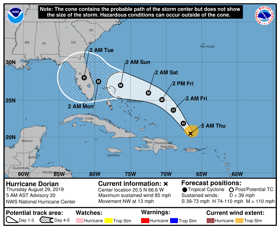
LOCATION…20.5N 66.6W
ABOUT 150 MI…240 KM NNW OF SAN JUAN PUERTO RICO
ABOUT 425 MI…685 KM ESE OF THE SOUTHEASTERN BAHAMAS
MAXIMUM SUSTAINED WINDS…85 MPH…140 KM/H
PRESENT MOVEMENT…NW OR 325 DEGREES AT 13 MPH…20 KM/H
MINIMUM CENTRAL PRESSURE…991 MB…29.27 INCHES
WATCHES AND WARNINGS
——————–
There are no coastal watches or warnings in effect.
Interests in the northwestern and central Bahamas should monitor the
progress of Dorian.
DISCUSSION AND OUTLOOK
———————-
At 500 AM AST (0900 UTC), the center of Hurricane Dorian was located
near latitude 20.5 North, longitude 66.6 West. Dorian is moving
toward the northwest near 13 mph (20 km/h), and this general motion
is expected to continue through Friday. A west-northwestward
motion is forecast to begin Friday night and continue into the
weekend. On this track, Dorian should move over the Atlantic well
east of the southeastern and central Bahamas today and on Friday,
and approach the northwestern Bahamas on Saturday.
Maximum sustained winds are near 85 mph (140 km/h) with higher
gusts. Strengthening is forecast during the next few days, and
Dorian is expected to become a major hurricane on Friday.
Hurricane-force winds extend outward up to 15 miles (30 km) from the
center, and tropical-storm-force winds extend outward up to 90 miles
(150 km).
The minimum central pressure based on earlier Air Force Reserve
Hurricane Hunter data is 991 mb (29.27 inches).
HAZARDS AFFECTING LAND
———————-
RAINFALL: Dorian is expected to produce the following rainfall
accumulations this weekend into early next week:
The central Bahamas…2 to 4 inches, isolated 6 inches.
The northwestern Bahamas and coastal sections of the Southeast
United States…4 to 8 inches, isolated 12 inches.
This rainfall may cause life-threatening flash floods.
SURF: Swells around the U.S. and British Virgin Islands and
Puerto Rico should gradually diminish today. Swells are likely to
begin affecting the east-facing shores of the Bahamas and the
southeastern United States coast during the next few days. These
swells are likely to cause life-threatening surf and rip current
conditions. Please consult products from your local weather office.
Related Articles: