…CENTER OF DORIAN MOVING NORTH-NORTHWESTWARD PARALLEL TO THE
NORTHEASTERN COAST OF FLORIDA…
SUMMARY OF 800 AM EDT…1200 UTC…INFORMATION
———————————————-
LOCATION…29.5N 79.6W
ABOUT 95 MI…155 KM ENE OF DAYTONA BEACH FLORIDA
ABOUT 135 MI…215 KM ESE OF JACKSONVILLE FLORIDA
MAXIMUM SUSTAINED WINDS…105 MPH…165 KM/H
PRESENT MOVEMENT…NNW OR 330 DEGREES AT 8 MPH…13 KM/H
MINIMUM CENTRAL PRESSURE…964 MB…28.47 INCHES
WATCHES AND WARNINGS
——————–
CHANGES WITH THIS ADVISORY:
None.
SUMMARY OF WATCHES AND WARNINGS IN EFFECT:
A Storm Surge Warning is in effect for…
* Sebastian Inlet FL to Surf City NC
A Storm Surge Watch is in effect for…
* North of Surf City NC to Poquoson VA, including Hampton Roads
* Pamlico and Albemarle Sounds
* Neuse and Pamlico Rivers
A Hurricane Warning is in effect for…
* Volusia/Brevard County FL line to Ponte Vedra Beach FL
* North of Savannah River to Surf City NC
A Hurricane Watch is in effect for…
* North of Ponte Vedra Beach FL to Savannah River
* North of Surf City NC to the North Carolina/Virginia border
* Albemarle and Pamlico Sounds
A Tropical Storm Warning is in effect for…
* Sebastian Inlet FL to the Volusia/Brevard County FL line
* North of Ponte Vedra Beach FL to Savannah River
A Tropical Storm Watch is in effect for…
* The North Carolina/Virginia border to Chincoteague VA
* Chesapeake Bay from Smith Point southward
A Storm Surge Warning means there is a danger of life-threatening
inundation, from rising water moving inland from the coastline,
during the next 36 hours in the indicated locations. For a depiction
of areas at risk, please see the National Weather Service Storm
Surge Watch/Warning Graphic, available at hurricanes.gov. This is a
life-threatening situation. Persons located within these areas
should take all necessary actions to protect life and property from
rising water and the potential for other dangerous conditions.
Promptly follow evacuation and other instructions from local
officials.
A Storm Surge Watch means there is a possibility of life-
threatening inundation, from rising water moving inland from the
coastline, in the indicated locations during the next 48 hours.
A Hurricane Warning means that hurricane conditions are expected
somewhere within the warning area. Preparations to protect life and
property should be rushed to completion.
A Hurricane Watch means that hurricane conditions are possible
within the watch area. A watch is typically issued 48 hours
before the anticipated first occurrence of tropical-storm-force
winds, conditions that make outside preparations difficult or
dangerous.
A Tropical Storm Warning means that tropical storm conditions are
expected within the warning area within 36 hours.
A Tropical Storm Watch means that tropical storm conditions are
possible within the watch area, generally within 48 hours.
Interests elsewhere along the Mid-Atlantic coast of the United
States should continue to monitor the progress of Dorian, as
additional watches or warnings may be required later today.
For storm information specific to your area in the United States,
including possible inland watches and warnings, please monitor
products issued by your local National Weather Service forecast
office.
DISCUSSION AND OUTLOOK
———————-
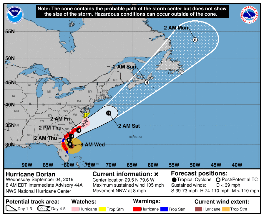
At 800 AM EDT (1200 UTC), the center of Hurricane Dorian was located
near latitude 29.5 North, longitude 79.6 West. Dorian is moving
toward the north-northwest near 8 mph (13 km/h), and a northwest or
north-northwest motion is expected through this morning. A turn
toward the north is forecast by this evening, followed by a turn
toward the north-northeast on Thursday morning. On this track, the
core of Hurricane Dorian will move dangerously close to the Florida
east coast and the Georgia coast through tonight. The center of
Dorian is forecast to move near or over the coast of South Carolina
and North Carolina Thursday through Friday morning.
Maximum sustained winds are near 105 mph (165 km/h) with higher
gusts. Some weakening is expected during the next couple of days.
However, Dorian is expected to remain a powerful hurricane during
the next few days.
Hurricane-force winds extend outward up to 60 miles (95 km) from
the center, and tropical-storm-force winds extend outward up to
175 miles (280 km). The NOAA automated station at St. Augustine
Beach, Florida, recently reported sustained winds of 46 mph (74
km/h) and a wind gust of 59 mph (94 km/h).
The minimum central pressure reported by an Air Force Reserve Unit
Hurricane Hunter aircraft is 964 mb (28.47 inches).
HAZARDS AFFECTING LAND
———————-
WIND: Tropical storm conditions are currently affecting portions of
the northeastern coast of Florida, and should begin along the
Georgia coast later this morning.
Hurricane conditions are expected somewhere within the Hurricane
Warning area in Florida today. Tropical storm conditions will begin
within the Hurricane Warning area in the Carolinas later today, with
hurricane conditions by tonight.
STORM SURGE: The combination of a dangerous storm surge and the
tide will cause normally dry areas near the coast to be flooded by
rising waters moving inland from the shoreline. The water could
reach the following heights above ground somewhere in the indicated
areas if the peak surge occurs at the time of high tide…
Isle of Palms to Myrtle Beach SC…5 to 8 ft
Savannah River to Isle of Palms SC…4 to 7 ft
Myrtle Beach SC to Cape Lookout NC…4 to 7 ft
Cape Lookout NC to Duck NC, including Pamlico and Albemarle Sounds
and the Neuse and Pamlico Rivers…4 to 6 ft
Volusia/Brevard County Line FL to Savannah River…3 to 5 ft
Sebastian Inlet FL to Volusia/Brevard County Line FL…2 to 4 ft
Duck NC to Poquoson VA, including Hampton Roads…2 to 4 ft
Water levels could begin to rise well in advance of the arrival of
strong winds. The surge will be accompanied by large and
destructive waves. Surge-related flooding depends on the how close
the center of Dorian comes to the coast, and can vary greatly over
short distances. For information specific to your area, please see
products issued by your local National Weather Service forecast
office.
RAINFALL: Dorian is expected to produce the following rainfall
totals through Friday:
Coastal Carolinas…5 to 10 inches, isolated 15 inches.
Atlantic Coast from Daytona Beach, Florida to the Georgia-South
Carolina border…3 to 6 inches, with isolated 9 inches near the
Georgia coast.
Southeast Virginia…3 to 6 inches.
This rainfall may cause life-threatening flash floods.
SURF: Large swells will affect the northwestern Bahamas, and
the entire southeastern United States coast from Florida through
North Carolina during the next several days. These swells are
likely to cause life-threatening surf and rip current conditions.
Please consult products from your local weather office.
TORNADOES: A tornado or two are possible near the immediate east
coast of Florida through tonight. This risk will shift to along the
immediate Georgia coast and the coastal Carolinas today into
Thursday.
Related Articles: