hurricane Matthew update 11am October 4, 2016
1100 AM EDT TUE OCT 04 2016
…EYE OF EXTREMELY DANGEROUS HURRICANE MATTHEW MOVING OVER
THE GULF OF GONAVE AND IS HEADING FOR EASTERN CUBA…
SUMMARY OF 1100 AM EDT…1500 UTC…INFORMATION
———————————————–
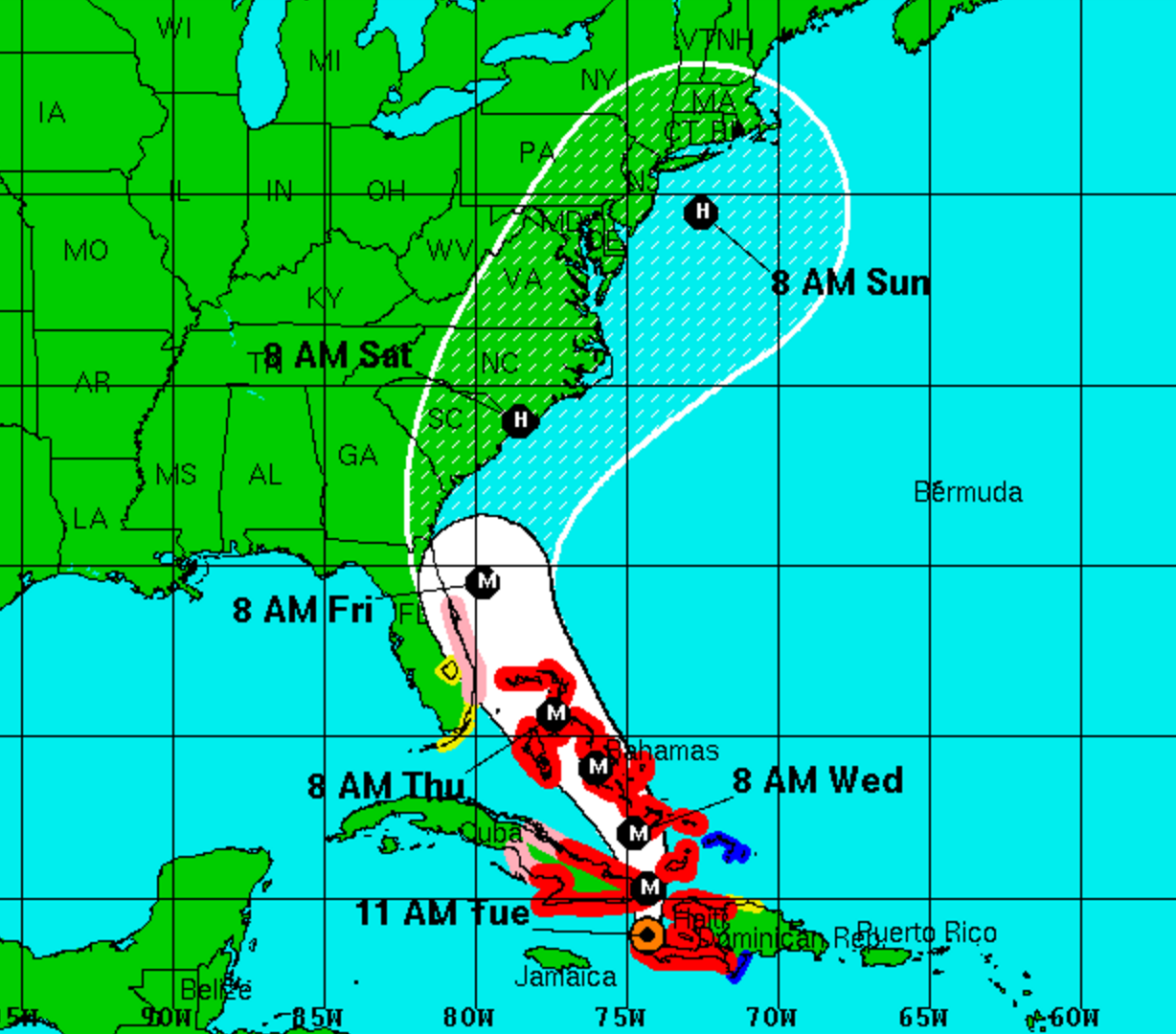
LOCATION…18.9N 74.3W
ABOUT 35 MI…60 KM NNE OF TIBURON HAITI
ABOUT 90 MI…145 KM S OF THE EASTERN TIP OF CUBA
MAXIMUM SUSTAINED WINDS…145 MPH…230 KM/H
PRESENT MOVEMENT…N OR 360 DEGREES AT 10 MPH…17 KM/H
MINIMUM CENTRAL PRESSURE…950 MB…28.06 INCHES
WATCHES AND WARNINGS
——————–
CHANGES WITH THIS ADVISORY:
A Hurricane Watch is in effect from Deerfield Beach, Florida to
the Volusia/Brevard county line.
A Tropical Storm Watch is in effect from the Seven Mile Bridge in
the Florida Keys northward to south of Deerfield Beach, including
Lake Okeechobee
The government of Jamaica has discontinued the Tropical Storm
Warning for Jamaica.
SUMMARY OF WATCHES AND WARNINGS IN EFFECT:
A Hurricane Warning is in effect for…
* Haiti
* Cuban provinces of Guantanamo, Santiago de Cuba, Holguin, Granma,
and Las Tunas
* Southeastern Bahamas, including the Inaguas, Mayaguana, Acklins,
Crooked Island, Long Cay, and Ragged Island
* Central Bahamas, including Long Island, Exuma, Rum Cay,
San Salvador, and Cat Island
* Northwestern Bahamas, including the Abacos, Andros Island,
Berry Islands, Bimini, Eleuthera, Grand Bahama Island, and
New Providence
A Hurricane Watch is in effect for…
* Cuban province of Camaguey
* Deerfield Beach to the Volusia/Brevard county line
A Tropical Storm Warning is in effect for…
* Dominican Republic from Barahona westward to the border with Haiti
* Turks and Caicos Islands
A Tropical Storm Watch is in effect for…
* Dominican Republic from Puerto Plata westward to the border with
Haiti
* Seven Mile Bridge to south of Deerfield Beach
* Lake Okeechobee
A Hurricane Watch means that hurricane conditions are possible
within the watch area. A watch is typically issued 48 hours before
the anticipated first occurrence of tropical-storm-force winds,
conditions that make outside preparations difficult or dangerous.
A Tropical Storm Watch means that tropical storm conditions are
possible within the watch area, generally within 48 hours.
Interests elsewhere in Hispaniola and in the Florida Peninsula and
the Florida Keys should monitor the progress of Matthew.
For storm information specific to your area in the United
States, including possible inland watches and warnings, please
monitor products issued by your local National Weather Service
forecast office. For storm information specific to your area outside
the United States, please monitor products issued by your national
meteorological service.
DISCUSSION AND 48-HOUR OUTLOOK
——————————
At 1100 AM EDT (1500 UTC), the eye of Hurricane Matthew was located
in the Gulf of Gonave near latitude 18.9 North, longitude 74.3 West.
Matthew is moving toward the north near 10 mph (17 km/h). On this
track the eye of Matthew will move over the Windward Passage and
eastern Cuba today. A turn toward the north-northwest is expected
by Wednesday, followed by a northwest turn Wednesday night. Matthew
is expected to move near or over portions of the southeastern and
central Bahamas tonight and Wednesday, and approach the northwestern
Bahamas Wednesday night.
Maximum sustained winds remain near 145 mph (230 km/h) with
higher gusts. Matthew is a category 4 hurricane on the Saffir-
Simpson Hurricane Wind Scale. Some fluctuations in intensity are
possible during the next couple of days, but Matthew is expected to
remain a powerful hurricane through at least Wednesday night.
Hurricane-force winds extend outward up to 60 miles (95 km) from the
center and tropical-storm-force winds extend outward up to 185 miles
(295 km).
The estimated minimum central pressure is 950 mb (28.06 inches).
HAZARDS AFFECTING LAND
———————-
WIND: Hurricane conditions are already affecting the southwestern
portion of Haiti, and these conditions will spread northward today.
Hurricane conditions are expected to reach eastern Cuba later today,
the southeastern Bahamas Tuesday evening, the central Bahamas on
Wednesday, and the northwestern Bahamas Wednesday night. Tropical
storm conditions are expected to continue spreading across the
remainder of Haiti today, eastern Cuba later this morning, the
southeastern Bahamas later today, and the central and northwestern
Bahamas Tuesday night and Wednesday, making outside preparations
difficult or dangerous.
Tropical storm conditions are expected in portions the Dominican
Republic within the warning area today, and will spread northward
into the Turks and Caicos Islands tonight.
Hurricane conditions are possible in the hurricane watch areas in
Cuba tonight with tropical storm conditions possible later today.
Hurricane conditions are possible within the hurricane watch
area in Florida by late Thursday, with tropical storm conditions
possible by early Thursday. Tropical storm condition are also
possible in the Florida tropical storm watch area by early Thursday.
RAINFALL: Matthew is expected to produce total rainfall amounts in
the following areas:
Southern Haiti and southwestern Dominican Republic…15 to 25
inches, isolated 40 inches
Eastern Cuba and northwestern Haiti…8 to 12 inches, isolated
20 inches
Eastern Jamaica…4 to 6 inches, isolated 10 inches
The Bahamas…8 to 12 inches, isolated 15 inches
Turks and Caicos Islands…2 to 5 inches, isolated 8 inches
Northeastern Haiti and the Northern Dominican Republic…1 to 3
inches, isolated 5 inches
Western Jamaica…1 to 2 inches, isolated 3 inches
Upper Florida Keys northward to coastal east-central Florida….4 to
7 inches, isolated 10 inches
Middle to Lower Florida Keys….1 to 3 inches, isolated 5 inches
Life-threatening flash floods and mudslides are likely from this
rainfall in southern and northwestern Haiti, the southwestern
Dominican Republic, and eastern Cuba.
STORM SURGE: The combination of a dangerous storm surge and large
and destructive waves could raise water levels by as much as the
following amounts above normal tide levels…
Southern Coast of Cuba east of Cabo Cruz…7 to 11 feet
South Coast of Haiti…7 to 10 feet
Northern Coast of Cuba east of Camaguey…4 to 6 feet
Jamaica…2 to 4 feet
Gulf of Gonave in Haiti…3 to 5 feet
Southern coast of the Dominican Republic…1 to 3 feet
The Bahamas…10 to 15 feet
Surge-related flooding depends on the relative timing of the surge
and the tidal cycle, and can vary greatly over short distances.
Large waves generated by Matthew will cause water rises to occur
well in advance of and well away from the track of the center.
SURF: Swells generated by Matthew will continue to affect portions
of the coasts of Hispaniola, Jamaica, eastern Cuba, and the
Caribbean coastline of Central America during the next few
days. Swells from Matthew will begin affecting portions of the
Bahamas on Tuesday. These swells are likely to cause life-
threatening surf and rip current conditions. Please consult
products from your local weather office.
NEXT ADVISORY
————-
Next intermediate advisory at 200 PM EDT.
Next complete advisory at 500 PM EDT.


