 500 AM EDT SAT OCT 01 2016
…MATTHEW WEAKENS SLIGHTLY AND IS NOW A CATEGORY 4 HURRICANE…
SUMMARY OF 500 AM EDT…0900 UTC…INFORMATION
———————————————-
LOCATION…13.3N 72.8W
ABOUT 365 MI…590 KM S OF PORT AU PRINCE HAITI
ABOUT 420 MI…675 KM SE OF KINGSTON JAMAICA
MAXIMUM SUSTAINED WINDS…155 MPH…250 KM/H
PRESENT MOVEMENT…W OR 270 DEGREES AT 7 MPH…11 KM/H
MINIMUM CENTRAL PRESSURE…942 MB…27.82 INCHES
WATCHES AND WARNINGS
——————–
CHANGES WITH THIS ADVISORY:
None.
SUMMARY OF WATCHES AND WARNINGS IN EFFECT:
A Hurricane Watch is in effect for…
* Jamaica
A Tropical Storm Warning is in effect for…
* Colombia/Venezuela border to Riohacha
A Tropical Storm Watch is in effect for…
* Haiti from the southern border with the Dominican Republic to
Port-Au-Prince
A Hurricane Watch means that hurricane conditions are possible
within the watch area. A watch is typically issued 48 hours before
the anticipated first occurrence of tropical-storm-force winds,
conditions that make outside preparations difficult or dangerous.
A Tropical Storm Warning means that tropical storm conditions are
expected somewhere within the warning area, in this case in the
next 12 hours.
A Tropical Storm Watch means that tropical storm conditions are
possible within the watch area, generally within 48 hours.
Interests elsewhere along the coasts of Venezuela and Colombia and
elsewhere in Hispaniola should monitor the progress of Matthew.
Interests in eastern Cuba should also monitor the progress of
Matthew.
For storm information specific to your area, please monitor
products issued by your national meteorological service.
DISCUSSION AND 48-HOUR OUTLOOK
——————————
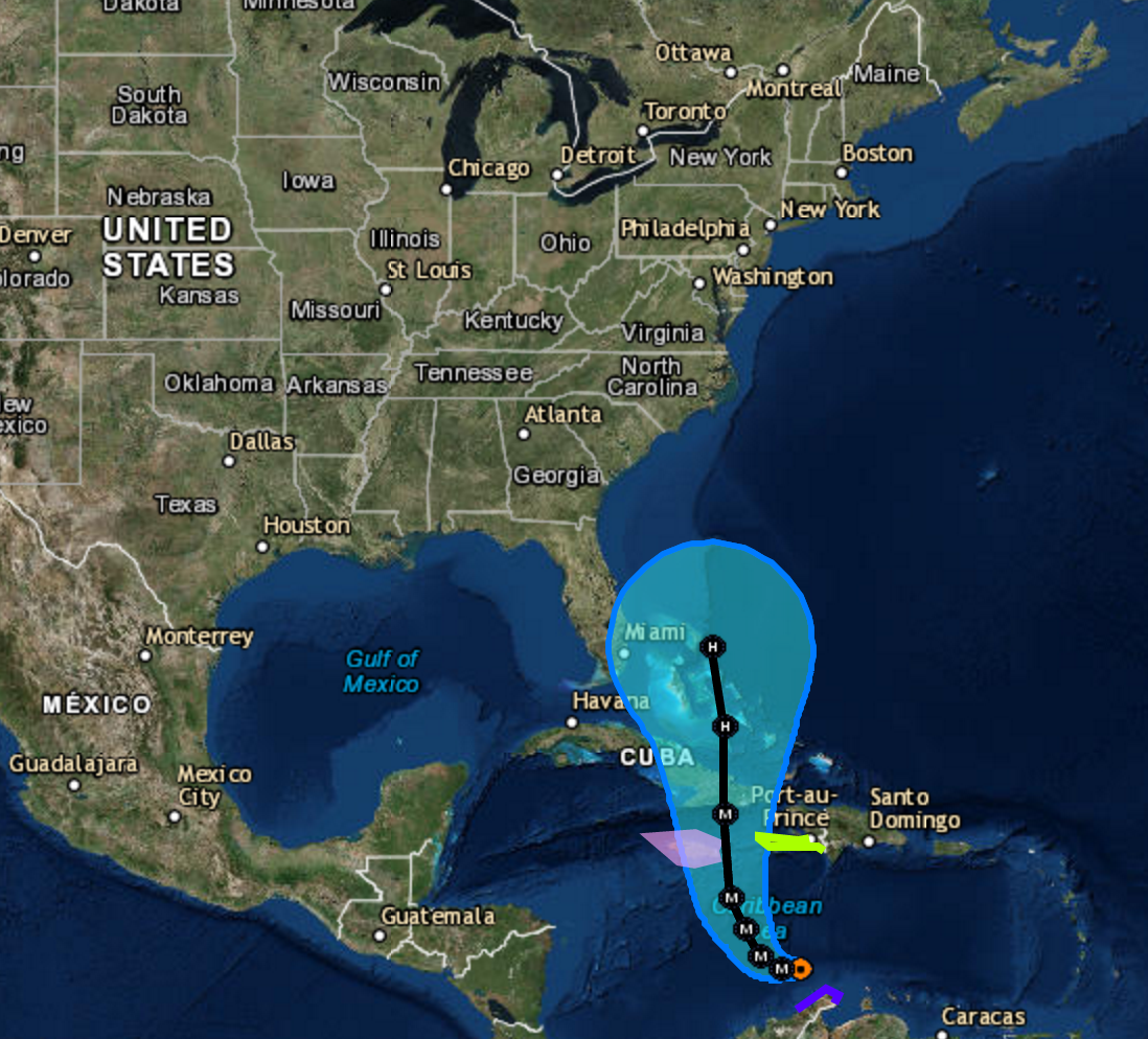
At 500 AM EDT (0900 UTC), the center of Hurricane Matthew was
located near latitude 13.3 North, longitude 72.8 West. Matthew is
moving toward the west near 7 mph (11 km/h). A turn toward the
west-northwest is forecast later today, followed by a turn toward
the north-northwest on Sunday. On the forecast track, the center of
Matthew will move away from the Guajira Peninsula this morning, move
across the central Caribbean Sea today, and be approaching Jamaica
late Sunday.
Maximum sustained winds are near 155 mph (250 km/h) with higher
gusts. Matthew is a category 4 hurricane on the Saffir-Simpson
Hurricane Wind Scale. Some fluctuations in intensity are possible
this weekend, but Matthew is expected to remain a powerful hurricane
through Sunday.
Hurricane-force winds extend outward up to 45 miles (75 km) from the
center and tropical-storm-force winds extend outward up to 205 miles
(335 km).
The estimated minimum central pressure is 942 mb (27.82 inches).
HAZARDS AFFECTING LAND
———————-
WIND: Tropical storm conditions are expected to continue in
portions of the warning area in Colombia for the next few hours.
Hurricane conditions are possible on Jamaica on Monday, with
tropical storm conditions possible by late Sunday. Tropical
storm conditions are possible in the watch area in Haiti by late
Sunday.
RAINFALL: Rainfall totals of 2 to 4 inches with isolated higher
amounts are expected over Aruba, Bonaire and Curacao through today.
Rainfall totals of 2 to 4 inches with isolated higher amounts are
expected along the coast of Colombia from the Venezuelan border to
Riohacha. Rainfall totals of 1 to 2 inches with isolated higher
amounts are expected along the coast of Venezuela from Coro to the
Colombian border.
Rainfall totals of 10 to 15 inches with isolated maximum amounts of
25 inches are expected across Jamaica and southern and southwestern
Haiti. These rains may produce life-threatening flash flooding and
mud slides.
SURF: Swells generated by Matthew are expected to affect portions
of the coasts of Puerto Rico, Hispaniola, Jamaica, Aruba, Bonaire,
Curacao, Venezuela, Colombia, and eastern Cuba during the next few
days. These swells are likely to cause life-threatening surf and rip
current conditions. Please consult products from your local weather
office.
500 AM EDT SAT OCT 01 2016
…MATTHEW WEAKENS SLIGHTLY AND IS NOW A CATEGORY 4 HURRICANE…
SUMMARY OF 500 AM EDT…0900 UTC…INFORMATION
———————————————-
LOCATION…13.3N 72.8W
ABOUT 365 MI…590 KM S OF PORT AU PRINCE HAITI
ABOUT 420 MI…675 KM SE OF KINGSTON JAMAICA
MAXIMUM SUSTAINED WINDS…155 MPH…250 KM/H
PRESENT MOVEMENT…W OR 270 DEGREES AT 7 MPH…11 KM/H
MINIMUM CENTRAL PRESSURE…942 MB…27.82 INCHES
WATCHES AND WARNINGS
——————–
CHANGES WITH THIS ADVISORY:
None.
SUMMARY OF WATCHES AND WARNINGS IN EFFECT:
A Hurricane Watch is in effect for…
* Jamaica
A Tropical Storm Warning is in effect for…
* Colombia/Venezuela border to Riohacha
A Tropical Storm Watch is in effect for…
* Haiti from the southern border with the Dominican Republic to
Port-Au-Prince
A Hurricane Watch means that hurricane conditions are possible
within the watch area. A watch is typically issued 48 hours before
the anticipated first occurrence of tropical-storm-force winds,
conditions that make outside preparations difficult or dangerous.
A Tropical Storm Warning means that tropical storm conditions are
expected somewhere within the warning area, in this case in the
next 12 hours.
A Tropical Storm Watch means that tropical storm conditions are
possible within the watch area, generally within 48 hours.
Interests elsewhere along the coasts of Venezuela and Colombia and
elsewhere in Hispaniola should monitor the progress of Matthew.
Interests in eastern Cuba should also monitor the progress of
Matthew.
For storm information specific to your area, please monitor
products issued by your national meteorological service.
DISCUSSION AND 48-HOUR OUTLOOK
——————————
At 500 AM EDT (0900 UTC), the center of Hurricane Matthew was
located near latitude 13.3 North, longitude 72.8 West. Matthew is
moving toward the west near 7 mph (11 km/h). A turn toward the
west-northwest is forecast later today, followed by a turn toward
the north-northwest on Sunday. On the forecast track, the center of
Matthew will move away from the Guajira Peninsula this morning, move
across the central Caribbean Sea today, and be approaching Jamaica
late Sunday.
Maximum sustained winds are near 155 mph (250 km/h) with higher
gusts. Matthew is a category 4 hurricane on the Saffir-Simpson
Hurricane Wind Scale. Some fluctuations in intensity are possible
this weekend, but Matthew is expected to remain a powerful hurricane
through Sunday.
Hurricane-force winds extend outward up to 45 miles (75 km) from the
center and tropical-storm-force winds extend outward up to 205 miles
(335 km).
The estimated minimum central pressure is 942 mb (27.82 inches).
HAZARDS AFFECTING LAND
———————-
WIND: Tropical storm conditions are expected to continue in
portions of the warning area in Colombia for the next few hours.
Hurricane conditions are possible on Jamaica on Monday, with
tropical storm conditions possible by late Sunday. Tropical
storm conditions are possible in the watch area in Haiti by late
Sunday.
RAINFALL: Rainfall totals of 2 to 4 inches with isolated higher
amounts are expected over Aruba, Bonaire and Curacao through today.
Rainfall totals of 2 to 4 inches with isolated higher amounts are
expected along the coast of Colombia from the Venezuelan border to
Riohacha. Rainfall totals of 1 to 2 inches with isolated higher
amounts are expected along the coast of Venezuela from Coro to the
Colombian border.
Rainfall totals of 10 to 15 inches with isolated maximum amounts of
25 inches are expected across Jamaica and southern and southwestern
Haiti. These rains may produce life-threatening flash flooding and
mud slides.
SURF: Swells generated by Matthew are expected to affect portions
of the coasts of Puerto Rico, Hispaniola, Jamaica, Aruba, Bonaire,
Curacao, Venezuela, Colombia, and eastern Cuba during the next few
days. These swells are likely to cause life-threatening surf and rip
current conditions. Please consult products from your local weather
office. Hurricane MATTHEW update 5am October 1, 2016
500 AM EDT SAT OCT 01 2016
…MATTHEW WEAKENS SLIGHTLY AND IS NOW A CATEGORY 4 HURRICANE…
SUMMARY OF 500 AM EDT…0900 UTC…INFORMATION
———————————————-
LOCATION…13.3N 72.8W
ABOUT 365 MI…590 KM S OF PORT AU PRINCE HAITI
ABOUT 420 MI…675 KM SE OF KINGSTON JAMAICA
MAXIMUM SUSTAINED WINDS…155 MPH…250 KM/H
PRESENT MOVEMENT…W OR 270 DEGREES AT 7 MPH…11 KM/H
MINIMUM CENTRAL PRESSURE…942 MB…27.82 INCHES
WATCHES AND WARNINGS
——————–
CHANGES WITH THIS ADVISORY:
None.
SUMMARY OF WATCHES AND WARNINGS IN EFFECT:
A Hurricane Watch is in effect for…
* Jamaica
A Tropical Storm Warning is in effect for…
* Colombia/Venezuela border to Riohacha
A Tropical Storm Watch is in effect for…
* Haiti from the southern border with the Dominican Republic to
Port-Au-Prince
A Hurricane Watch means that hurricane conditions are possible
within the watch area. A watch is typically issued 48 hours before
the anticipated first occurrence of tropical-storm-force winds,
conditions that make outside preparations difficult or dangerous.
A Tropical Storm Warning means that tropical storm conditions are
expected somewhere within the warning area, in this case in the
next 12 hours.
A Tropical Storm Watch means that tropical storm conditions are
possible within the watch area, generally within 48 hours.
Interests elsewhere along the coasts of Venezuela and Colombia and
elsewhere in Hispaniola should monitor the progress of Matthew.
Interests in eastern Cuba should also monitor the progress of
Matthew.
For storm information specific to your area, please monitor
products issued by your national meteorological service.
DISCUSSION AND 48-HOUR OUTLOOK
——————————
At 500 AM EDT (0900 UTC), the center of Hurricane Matthew was
located near latitude 13.3 North, longitude 72.8 West. Matthew is
moving toward the west near 7 mph (11 km/h). A turn toward the
west-northwest is forecast later today, followed by a turn toward
the north-northwest on Sunday. On the forecast track, the center of
Matthew will move away from the Guajira Peninsula this morning, move
across the central Caribbean Sea today, and be approaching Jamaica
late Sunday.
Maximum sustained winds are near 155 mph (250 km/h) with higher
gusts. Matthew is a category 4 hurricane on the Saffir-Simpson
Hurricane Wind Scale. Some fluctuations in intensity are possible
this weekend, but Matthew is expected to remain a powerful hurricane
through Sunday.
Hurricane-force winds extend outward up to 45 miles (75 km) from the
center and tropical-storm-force winds extend outward up to 205 miles
(335 km).
The estimated minimum central pressure is 942 mb (27.82 inches).
HAZARDS AFFECTING LAND
———————-
WIND: Tropical storm conditions are expected to continue in
portions of the warning area in Colombia for the next few hours.
Hurricane conditions are possible on Jamaica on Monday, with
tropical storm conditions possible by late Sunday. Tropical
storm conditions are possible in the watch area in Haiti by late
Sunday.
RAINFALL: Rainfall totals of 2 to 4 inches with isolated higher
amounts are expected over Aruba, Bonaire and Curacao through today.
Rainfall totals of 2 to 4 inches with isolated higher amounts are
expected along the coast of Colombia from the Venezuelan border to
Riohacha. Rainfall totals of 1 to 2 inches with isolated higher
amounts are expected along the coast of Venezuela from Coro to the
Colombian border.
Rainfall totals of 10 to 15 inches with isolated maximum amounts of
25 inches are expected across Jamaica and southern and southwestern
Haiti. These rains may produce life-threatening flash flooding and
mud slides.
SURF: Swells generated by Matthew are expected to affect portions
of the coasts of Puerto Rico, Hispaniola, Jamaica, Aruba, Bonaire,
Curacao, Venezuela, Colombia, and eastern Cuba during the next few
days. These swells are likely to cause life-threatening surf and rip
current conditions. Please consult products from your local weather
office.
This entry was posted in Weather Articles and tagged Atlantic Hurricanes, Hurricane Matthew, hurricanes. Bookmark the permalink.
Read More

Upper Ohio Valley Severe Weather: Enhanced Risk July 21, 2026
Upper Ohio Valley severe weather is the headline threat on July 21, 2026, as the NOAA Storm Prediction Center (SPC) has issued an Enhanced Risk stretching from the Ohio Valley through the Mid-Atlantic and into the…

Upper Midwest Severe Thunderstorms: Enhanced Risk July 20, 2026
Upper Midwest severe thunderstorms are threatening Minnesota, Wisconsin, Iowa, Upper Michigan, and the broader Great Lakes region today, July 20, 2026, with the NOAA Storm Prediction Center placing the area under an Enhanced Risk, the third…

Southeast Severe Thunderstorms and Dakotas Hail Threat: SPC Outlook for July 19, 2026
Southeast severe thunderstorms are the lead hazard in today's Storm Prediction Center Day 1 Convective Outlook, issued July 19, 2026, with the SPC placing a Slight Risk, the second of five severe categories (level 2 of…