
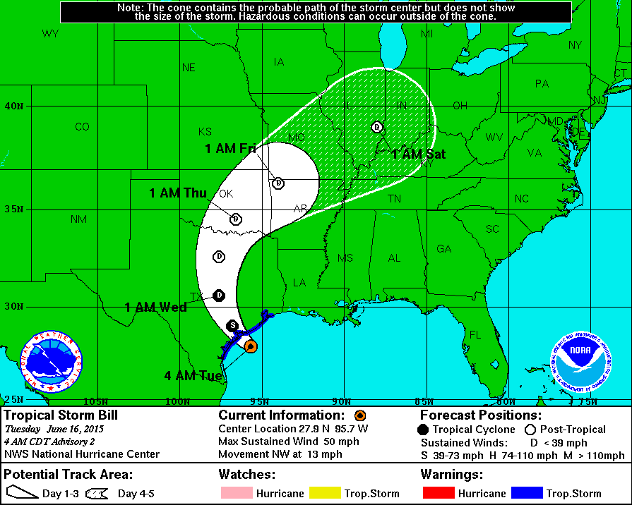
 At 400 AM CDT (0900 UTC), the center of Tropical Storm Bill was
located near latitude 27.9 North, longitude 95.7 West. Bill is
moving toward the northwest near 13 mph (20 km/h) and this general
motion is expected to continue today. On the forecast track, the
center of Bill is expected to make landfall in the warning area
along the Texas coast later this morning and move inland over
south-central Texas this afternoon and tonight.
Maximum sustained winds remain near 50 mph (85 km/h) with higher
gusts. Little change in strength is likely before landfall.
Weakening is forecast after the center moves inland later today, and
Bill is expected to weaken to a tropical depression tonight.
Tropical storm force winds extend outward up to 150 miles (240 km)
from the center.
The estimated minimum central pressure is 1004 mb (29.65 inches).
Track tropical storm bill at http://iAlert.com
At 400 AM CDT (0900 UTC), the center of Tropical Storm Bill was
located near latitude 27.9 North, longitude 95.7 West. Bill is
moving toward the northwest near 13 mph (20 km/h) and this general
motion is expected to continue today. On the forecast track, the
center of Bill is expected to make landfall in the warning area
along the Texas coast later this morning and move inland over
south-central Texas this afternoon and tonight.
Maximum sustained winds remain near 50 mph (85 km/h) with higher
gusts. Little change in strength is likely before landfall.
Weakening is forecast after the center moves inland later today, and
Bill is expected to weaken to a tropical depression tonight.
Tropical storm force winds extend outward up to 150 miles (240 km)
from the center.
The estimated minimum central pressure is 1004 mb (29.65 inches).
Track tropical storm bill at http://iAlert.com Tropical Storm BILL Texas Landfall
At 400 AM CDT (0900 UTC), the center of Tropical Storm Bill was
located near latitude 27.9 North, longitude 95.7 West. Bill is
moving toward the northwest near 13 mph (20 km/h) and this general
motion is expected to continue today. On the forecast track, the
center of Bill is expected to make landfall in the warning area
along the Texas coast later this morning and move inland over
south-central Texas this afternoon and tonight.
Maximum sustained winds remain near 50 mph (85 km/h) with higher
gusts. Little change in strength is likely before landfall.
Weakening is forecast after the center moves inland later today, and
Bill is expected to weaken to a tropical depression tonight.
Tropical storm force winds extend outward up to 150 miles (240 km)
from the center.
The estimated minimum central pressure is 1004 mb (29.65 inches).
Track tropical storm bill at http://iAlert.com
This entry was posted in Weather Articles and tagged atlantic hurrican season, gulf tropical storms, historic tropical weather, Texas, Tropical, tropical depression, tropical storm. Bookmark the permalink.
Read More

Southern Plains Severe Storms: SPC Slight Risk for Oklahoma and West Texas on October 14, 2026
Southern Plains severe storms are the main severe weather concern across the country on Wednesday, October 14, 2026, with the NOAA Storm Prediction Center placing Oklahoma City, Lawton and Ardmore in Oklahoma, along with Midland, Odessa…

Panama Earthquake: Magnitude 7.7 Strikes Near Pitaloza Arriba, USGS Issues RED Alert
USGS ShakeMap of the M7.7 Panama earthquake. The star marks the epicenter; red and orange contours show the strongest estimated shaking. Source: U.S. Geological Survey. A powerful Panama earthquake struck the Azuero Peninsula on Friday, October…

Hurricane Isaias Landfall Expected Tonight on the Northern Gulf Coast as Storm Nears Major Hurricane Strength
Hurricane Isaias position at 7 AM CDT Friday, October 9, 2026, with the NHC forecast track and cone toward the northern Gulf Coast and active coastal and inland warnings. Map: iAlert.com Hurricane Isaias landfall is expected…