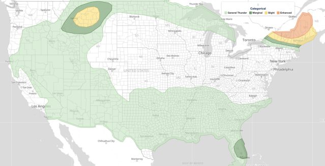
Central Plains severe weather is forecast to strike eastern Colorado, western and central Kansas, and southern Nebraska on Saturday, June 20, 2026, with the Storm Prediction Center (SPC) issuing an Enhanced Risk outlook for the region. The SPC warns that large to very large hail, damaging winds topping 75 mph, and tornadoes are all possible during the afternoon and evening hours, making this one of the more significant severe weather setups of the early summer season.
Key points:
- SPC has issued an Enhanced Risk (level 3 of 5) for eastern Colorado, western/central Kansas, and southern Nebraska.
- Main hazards: large to very large hail, winds exceeding 75 mph, and tornadoes.
- NWS Hastings issued a Flood Watch for Greeley and Valley Counties, Nebraska, through Sunday morning.
- Rainfall totals of 3 to 5 inches possible in the Flood Watch area Saturday evening into Sunday.
- Flash Flood Warnings were also issued in central Texas and northwestern Louisiana early June 20.
What the SPC’s Enhanced Risk Means for the Central Plains
The SPC’s 1200 UTC Day 1 Convective Outlook, valid from June 20 through June 21 at 1200 UTC, identifies a low-amplitude mid- and upper-level shortwave trough moving from the Intermountain West toward the central and northern Plains as the primary driver of the threat. An Enhanced Risk is the third of five categories in SPC’s system and signals that widespread severe thunderstorms are likely, not merely possible, across the highlighted area.
The combination of hazards on the table is notable. Very large hail, winds above 75 mph, and tornadoes can each occur independently in a Plains outbreak, but their simultaneous likelihood in one outlook points to a well-organized and energetic storm mode.
Flood Watch and Flash Flood Warnings Expand the Risk
NWS Hastings, Nebraska, issued a Flood Watch for Greeley and Valley Counties effective Saturday evening through 7:00 AM CDT Sunday, June 21. Forecasters warn that thunderstorms could drop 3 to 5 inches of rain within the watch area, enough to cause excessive runoff into rivers, creeks, streams, and low-lying locations.
Separate Flash Flood Warnings were already in effect early Saturday morning well to the south. NWS Fort Worth issued a Flash Flood Warning until 10:00 AM CDT for southern Freestone County, Leon County, and east-central Limestone County in central Texas. Doppler radar estimated 4 to 8 inches of rain had fallen by 6:15 AM CDT, leaving numerous roads flooded and impassable.
NWS Shreveport issued a Flash Flood Warning until 9:45 AM CDT for portions of northwestern Louisiana, including De Soto, Red River, southern Bossier, southeastern Caddo, southwestern Bienville, and northwestern Natchitoches Parishes, where 1 to 3 inches of rain had accumulated.
These morning warnings show the broader weather pattern affecting the region was already producing heavy rainfall before the main Plains event developed.
Meteorologist’s Take
Central Plains severe weather outbreaks driven by shortwave troughs moving out of the Intermountain West are a well understood and recurring summertime pattern. When a shortwave trough interacts with a moist, unstable air mass already in place over the Plains, it provides the lift needed to initiate discrete supercell thunderstorms. Supercells are the storm type most capable of producing very large hail and significant tornadoes, which is why the SPC specifically highlighted those hazards in today’s outlook.
The simultaneous flash flooding threat is also meteorologically consistent. As storms train or slow over an area, a storm that produces 2 to 3 inches of rain in under an hour can overwhelm drainage systems in flat terrain. The 3-to-5-inch totals projected for the Greeley and Valley County Flood Watch area represent a serious hydrological risk independent of any wind or hail damage. Residents in and near creek and river corridors should treat flood guidance with equal urgency as the severe thunderstorm threat.
The morning Flash Flood Warnings in Texas and Louisiana also reflect a region that had already received heavy rainfall from overnight convection, leaving soils saturated and runoff potential elevated heading into the afternoon heating cycle.
How to Stay Safe During Central Plains Severe Weather
During central Plains severe weather, the combination of large hail, damaging winds, tornadoes, and flash flooding requires preparation on multiple fronts. Have a NOAA Weather Radio or a reliable weather app with push alerts active before storms arrive. If a Tornado Warning is issued, move to an interior room on the lowest floor of a sturdy building, away from windows.
For flash flooding, remember that just 6 inches of fast-moving water can knock a person down, and 1 to 2 feet can sweep away most vehicles. Turn around, do not drown. Check active weather alerts on iAlert before driving in storm-threatened areas, and monitor your local weather forecast for updated guidance throughout the day. Stay off flooded roads even after rain stops, as rivers can continue to rise for hours.
For ongoing radar and alert monitoring as this central Plains severe weather event unfolds, track live radar and alerts at iAlert and sign up for location alert notifications through iAlert weather alerts and notifications.
Sources: