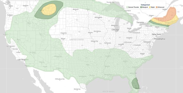
Severe weather June 22, 2026 is possible as the NOAA Storm Prediction Center (SPC) has issued a Day 1 Convective Outlook carrying a Slight Risk, the second of five risk categories. The outlook identifies General Thunderstorm, Marginal, and Slight areas across portions of the United States for today.
Key points:
- SPC rates today’s threat at Slight Risk (level 2 of 5).
- Two severe risk levels are in play, Marginal and Slight, plus a General Thunderstorm area.
- The outlook is valid for June 22, 2026.
- Main hazards: large hail, damaging winds, and an isolated tornado threat.
What a Slight Risk Means for You Today
The SPC uses a five-tier system to communicate severe weather potential: Marginal, Slight, Enhanced, Moderate, and High. A separate General Thunderstorm area marks non-severe storms. A Slight Risk indicates that scattered severe thunderstorms are possible, but widespread, organized severe weather is not expected. Typical hazards associated with a Slight Risk day include large hail, damaging wind gusts, and an isolated tornado threat.
The severe weather June 22 outlook places two severe risk levels in play, Marginal and Slight, alongside a broader General Thunderstorm area, which tells us that confidence and storm intensity vary notably by location. Areas in the Slight zone face the highest probability of seeing a qualifying severe weather report, meaning hail at least one inch in diameter, wind gusts of 58 mph or greater, or a tornado.
Residents in any of the severe weather June 22 highlighted zones should treat today as an active weather day. Even a Marginal or General Thunderstorm designation means storm coverage and lightning are concerns, even if organized severe weather remains unlikely. Check your active weather alerts on iAlert to see whether your county is currently under any watch or warning.
Meteorologist’s Take
A Slight Risk on any given June day is not unusual. Summer atmospheric setups frequently produce scattered strong to severe storms, especially where daytime heating interacts with available moisture and wind shear. What matters most is the local environment in the hours surrounding peak heating, typically mid-afternoon through early evening.
Severe weather June 22 follows a pattern common to early summer convective outlooks: broad areas of marginal instability with localized corridors where conditions support more organized storm structures. The fact that the SPC carved out a Slight Risk zone suggests at least some regional focus for storm development, even if exact storm tracks remain uncertain this far in advance of initiation.
The multi-tier structure of today’s outlook is a reminder that severe weather threat is not binary. Even in a General Thunderstorm area, dangerous cloud-to-ground lightning, heavy rain, and brief gusty winds can accompany any storm. Always treat a rumble of thunder as your cue to seek shelter indoors immediately.
How to Stay Safe on Severe Weather June 22
If you are in or near a Slight Risk area on severe weather June 22, take these steps now, before storms develop:
- Monitor your live radar and alerts on iAlert for storm development in real time.
- Identify a safe interior room on the lowest floor of a sturdy building, away from windows.
- Avoid open fields, hilltops, and bodies of water during any thunderstorm, regardless of risk level.
- If driving, never attempt to cross flooded roadways. Turn around, don’t drown.
- Charge your devices now so you have communication tools if power is disrupted.
Severe weather June 22 carries a manageable but real threat. Staying informed is your best defense. Bookmark your local weather forecast on iAlert and check back throughout the day, since the SPC can upgrade a Slight Risk if the atmosphere becomes more favorable for organized storms.
Sources: