Potential Tropical Cyclone One is producing life-threatening and dangerous flash flooding across portions of Texas and Louisiana as of Tuesday, June 16, 2026. The National Hurricane Center in Miami classified the system as a potential tropical cyclone and has been issuing regular advisories since early Tuesday afternoon, warning that flooding impacts are already occurring and are expected to continue.
Key points:
- Life-threatening flooding is ongoing across parts of Texas and Louisiana.
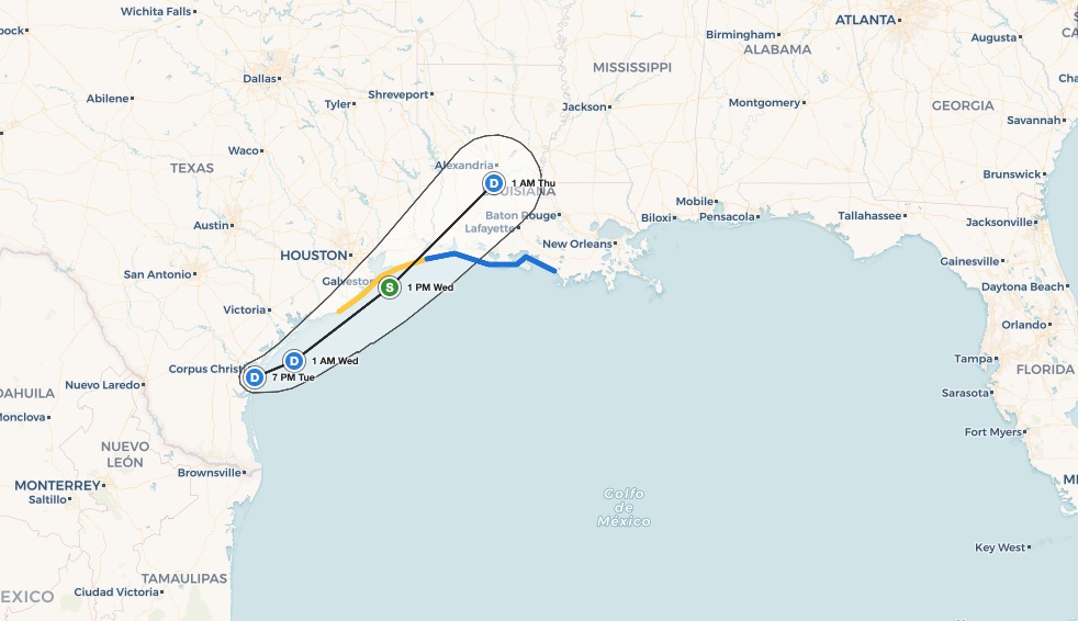
- System center was about 15 miles SSE of Corpus Christi, Texas at 7:00 PM CDT June 16.
- Maximum sustained winds of 30 mph; moving northeast at 6 mph.
- NHC gives a 70 percent formation chance within 48 hours and 7 days.
- Central pressure has tightened from 1007 mb to 1004 mb through the day.
What Potential Tropical Cyclone One Is Doing Right Now
As of the 7:00 PM CDT advisory on June 16, the NHC placed the center of Potential Tropical Cyclone One near 27.6N, 97.3W, roughly 15 miles south-southeast of Corpus Christi, Texas, and approximately 300 miles southwest of Lake Charles, Louisiana. The system was moving northeast at 6 mph with maximum sustained winds of 30 mph and gusts to around 35 mph. Central pressure stood at 1004 mb, down from 1007 mb at the opening advisory issued around 10:00 AM CDT, indicating a slow but steady intensification trend through the day.
By 1:00 PM CDT, the NHC was already describing dangerous flash flooding as actively occurring over portions of Texas and Louisiana. By the 7:00 PM CDT advisory, the language had escalated to life-threatening flooding, signaling that conditions had worsened through the afternoon hours. The NHC’s Atlantic Tropical Weather Outlook, updated at both 2:00 PM and 8:00 PM EDT, confirmed a high probability of tropical cyclone formation: 70 percent within 48 hours and 70 percent over the next seven days.
Track and Intensity Outlook
Forecast advisories from the NHC show the system continuing on a northeast track at roughly 5 knots. Position uncertainty in the first advisory was within 60 nautical miles, tightening to 45 nautical miles by the second forecast advisory at 2100 UTC. This northeastward drift is carrying the circulation and its heavy moisture plume directly into the Texas Coastal Bend and toward southwest Louisiana, which explains why both states are experiencing serious flooding impacts even while the system remains below tropical storm strength.
The NHC’s 70 percent formation probability is notable. A system does not need to become a named tropical storm to cause catastrophic flooding. Potential tropical cyclones are designated precisely because they can deliver tropical-storm-force rain and flooding before formal classification criteria are met.
Meteorologist’s Take
Potential Tropical Cyclone One is a textbook example of a moisture-laden, poorly organized tropical system that poses its greatest danger from rainfall rather than wind. Systems tracking onshore along the Texas coast often draw deep Gulf moisture and stall or slow as they interact with land, dramatically increasing rainfall totals. The gradual pressure fall from 1007 mb to 1004 mb over the course of Tuesday suggests the system is finding some organization, but the flooding threat is already critical regardless of whether it achieves tropical storm status.
The northeast movement at only 5 to 6 mph is slow enough that any single location in the path can receive prolonged, intense rainfall. Flash flooding and river flooding can develop and worsen over many hours under these conditions. The Texas Coastal Bend and the corridor toward southwest Louisiana are the areas of greatest concern based on current NHC advisories. Residents should not wait for a formal tropical storm designation to take protective action.
How to Stay Safe During Potential Tropical Cyclone One
Flooding is the leading cause of death in tropical systems. If you are in the path of Potential Tropical Cyclone One across southern Texas or Louisiana, follow these core safety steps. Never attempt to drive through flooded roadways: just six inches of fast-moving water can knock a person down, and two feet can sweep away most vehicles. Move to higher ground immediately if you are in a flood-prone area and do not wait for an official evacuation order if you feel at risk.
Stay informed in real time. You can track and monitor tropical systems on iAlert to receive the latest NWS warnings and watches as conditions evolve. Have a battery-powered or hand-crank weather radio as a backup if power is lost. Prepare an emergency kit with at least 72 hours of food, water, medications, and important documents stored in a waterproof container.
Potential Tropical Cyclone One remains a dangerous and evolving situation for Texas and Louisiana. Monitor every NHC advisory update closely, follow instructions from local emergency managers, and treat any flash flood warning in your county as a life-safety emergency. Check live radar and alerts on iAlert for the most current conditions near you.
Sources:
- NHC Public Advisory 2A for Potential Tropical Cyclone One, 7:00 PM CDT June 16, 2026 (NOAA/NHC)
- NHC Public Advisory 1A for Potential Tropical Cyclone One, 1:00 PM CDT June 16, 2026 (NOAA/NHC)
- NHC Forecast Advisory 1 for Potential Tropical Cyclone One, 1500 UTC June 16, 2026 (NOAA/NHC)
- NHC Forecast Advisory 2 for Potential Tropical Cyclone One, 2100 UTC June 16, 2026 (NOAA/NHC)
- NHC Atlantic Tropical Weather Outlook, updated 8:00 PM EDT June 16, 2026 (NOAA/NHC)