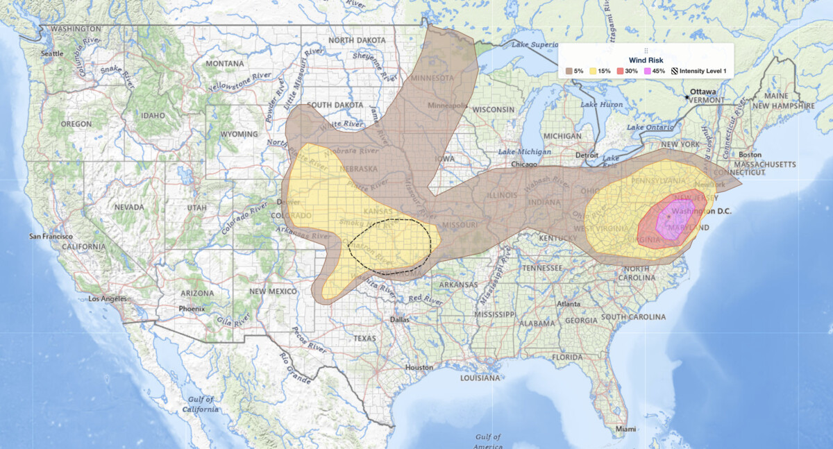
Mid-Atlantic severe thunderstorms are the top weather threat on Independence Day, July 4, 2026, and Washington DC sits squarely inside the highest damaging wind risk in the country. The NOAA Storm Prediction Center has issued an Enhanced Risk, the third of five severe categories (level 3 of 5), for portions of the Mid-Atlantic, and its highest wind-probability contour, 45 percent, is centered directly over the Washington DC and Baltimore metro areas. Storm clusters sweeping from the Blue Ridge Mountains and Shenandoah Valley northeastward into Pennsylvania, New Jersey, Maryland, Virginia, and West Virginia could arrive during evening holiday celebrations.
Key points:
- Mid-Atlantic severe thunderstorms carry an Enhanced Risk (level 3 of 5) for portions of the region on July 4.
- Washington DC and Baltimore sit inside the SPC’s highest wind-probability contour: 45% chance of damaging wind gusts.
- Storms may still be active during evening July 4 fireworks across the DC, Maryland, and Northern Virginia area.
- Large hail is possible across the Central and Southern Plains (15% probability), where a Slight Risk (level 2 of 5) is in place.
- Temperatures in the Mid-Atlantic may climb into the 90s to 100s °F ahead of storms.
What the SPC Is Forecasting for July 4
The SPC’s Day 1 Convective Outlook identifies two distinct severe weather areas today. The higher-end threat comes from Mid-Atlantic severe thunderstorms expected to develop along the Blue Ridge Mountains and Shenandoah Valley and track north and eastward through the afternoon. The SPC warns these clusters have the potential to produce widespread damaging wind, particularly if they grow upscale and generate strong cold pools.
The wind-probability map tells the sharpest part of the story. The SPC’s highest contour, a 45 percent chance of damaging wind gusts, sits directly over Washington DC, Baltimore, and the surrounding Maryland and Northern Virginia suburbs. That is the most concentrated damaging wind threat anywhere in the country today, and it lands on the region’s biggest outdoor holiday.
Lingering morning convection across northern Pennsylvania into northern New Jersey may limit daytime heating in that corridor, but areas to the south, including West Virginia, Virginia, Maryland, and southern New Jersey, face the most intense afternoon instability.
Separate from the Mid-Atlantic threat, a Slight Risk, the second of five severe categories (level 2 of 5), covers portions of the Central and Southern Plains for Saturday afternoon and evening. SPC uses a five-tier system to communicate severe weather potential, and you can explore each level in detail with this guide to SPC outlook risk categories. Within the Plains risk area, the SPC puts the probability of large hail at 15 percent, damaging wind at 45 percent, and a tornado at 2 percent.
Meteorologist’s Take
The atmosphere fueling today’s Mid-Atlantic severe thunderstorms is being shaped by an upper-level trough parked over the Northeast and into Quebec and Ontario. A modest belt of westerly winds, running at roughly 30 to 40 knots, is wrapping around that trough and threading through the Mid-Atlantic region. That jet-level flow provides the storm organization needed for clusters to sustain themselves and move efficiently, even though the overall deep-layer wind shear across much of the region is described by the SPC as generally weak.
Better shear exists toward the northern fringe of the risk area, which is why the northern storm clusters may also produce damaging wind despite less instability.
The key ingredient driving Mid-Atlantic severe thunderstorms in the southern part of the Enhanced Risk zone is extreme surface heat. Temperatures climbing into the 90s to 100s °F will rapidly destabilize the lower atmosphere during the afternoon hours. A plume of steep mid-level lapse rates, meaning the temperature falls off sharply with altitude, is already in place from West Virginia into Virginia, Maryland, and New Jersey. That combination of surface heat and steep lapse rates creates moderate to strong instability by peak heating.
When storm clusters tap that energy, they can produce powerful downburst winds as cold, rain-cooled air slams into the ground and spreads outward. The SPC specifically notes that clusters growing upscale and forming strong cold pools will be the mechanism most likely to produce the most widespread wind damage. The DC and Baltimore metro areas sit at the focus of that setup, which is why the 45 percent wind contour is drawn there.
Over the Central and Southern Plains, a compact shortwave trough, a small but energetic ripple in the upper-level flow, will push through with enhanced westerly winds. That feature drives afternoon and evening convection with a mixed hazard profile of wind, hail, and a very low tornado chance.
How to Stay Safe from Mid-Atlantic Severe Thunderstorms Today
Because damaging wind is the dominant hazard for today’s Mid-Atlantic severe thunderstorms, the primary safety priority is getting indoors and away from trees, power lines, and windows before storms arrive. Wind damage from downbursts can occur with little warning and over a wide swath, not just near the storm’s visible core. Move outdoor furniture, tents, and decorations indoors now, since July 4 celebrations leave many items outside that become dangerous projectiles in gusty winds.
If you have plans for fireworks or an outdoor gathering in the DC, Baltimore, or Northern Virginia area this evening, identify your shelter before you leave home. A sturdy building or a hard-topped vehicle beats a tent, pavilion, or open field, all of which are dangerous in downburst winds. Storms may still be active during show time, so be ready for delays or cancellations and leave early if skies darken to the west.
If you are in the Central or Southern Plains, large hail up to the 15 percent probability threshold warrants moving vehicles under cover and staying away from skylights and glass when storms approach. Keep an eye on live radar and active alerts throughout the afternoon and evening, and sign up for iAlert weather alerts and notifications to receive warnings the moment watches or warnings are issued for your county.
Check your local weather forecast before heading to any outdoor July 4 event, and do not wait for rain to begin before seeking shelter.
Mid-Atlantic severe thunderstorms will remain a threat into this evening. Monitor conditions closely and prioritize safety over outdoor celebrations if storms are approaching your location.
Sources:
Get Severe Weather Alerts for Your Location
When any NWS watch, warning, or advisory is issued for your area, iAlert sends you an immediate notification by email, text message, or phone call, 24 hours a day, 7 days a week.
Sign Up for Severe Weather Alerts →

