
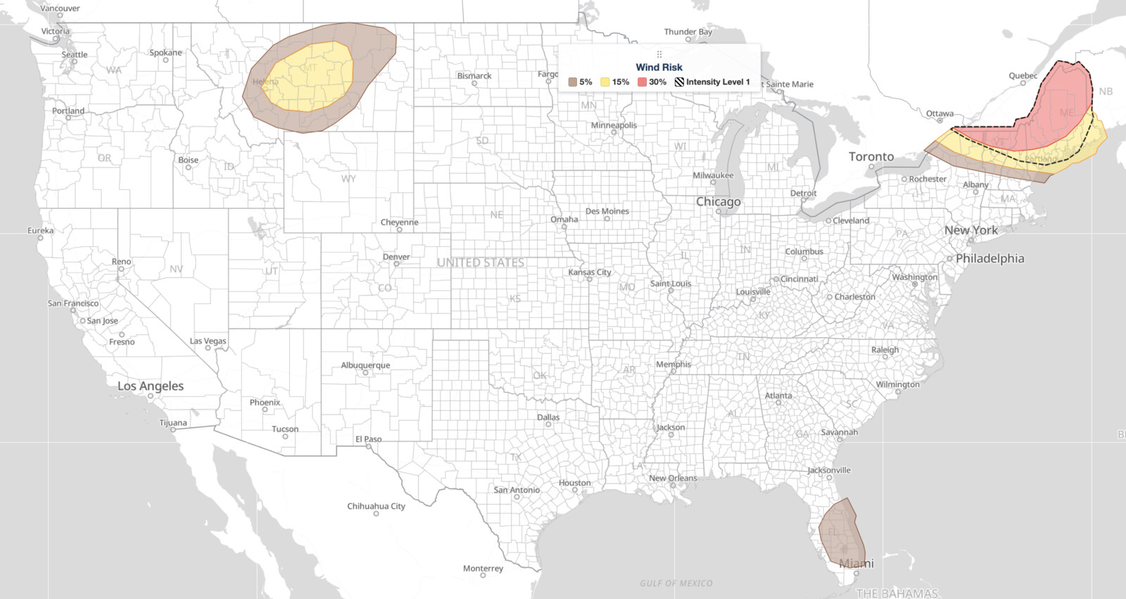
Northeast severe thunderstorms are set to impact northern New York and northern New England on July 14, 2026, as the NOAA Storm Prediction Center has issued an Enhanced Risk outlook covering the region. The Enhanced Risk is the third of five severe categories, placing this event above a Slight Risk but signaling a genuine threat of widespread, organized severe weather including damaging wind gusts, large hail, and at least the potential for a strong tornado.
Key points:
- Enhanced Risk (level 3 of 5) issued for northern New York and northern New England.
- Damaging wind gusts above 70 mph are possible, especially with intense line segments.
- Large hail and tornado potential highest from northern New York into northern Vermont and northwest Maine.
- Storm-relative helicity of 250 to 300 m²/s² suggests a strong tornado is possible.
- SPC hazard probabilities: tornado 5%, large hail 15%, damaging wind 30%.
What the SPC Is Forecasting for July 14
For these Northeast severe thunderstorms, the SPC’s outlook highlights a corridor from northern New York through northern Vermont and into northwest Maine as the core of the greatest severe weather potential. Storms are expected to develop by mid to late afternoon along a pre-frontal trough extending from near Lake Ontario northeastward into far southern Quebec, then move southeastward into the highest-risk areas. Isolated severe wind gusts and hail are also possible in parts of the northern Rockies and northern High Plains, though the primary focus for organized severe weather remains firmly in the Northeast.
The SPC places the probability of damaging winds at 30 percent, large hail at 15 percent, and tornadoes at 5 percent within the outlined risk areas. While tornado probability appears modest, the atmospheric setup in the northern New York to northwest Maine corridor supports the potential for a strong tornado, making this more than a routine wind and hail event. Residents in those areas should treat the tornado threat seriously.
Meteorologist’s Take
The engine driving today’s Northeast severe thunderstorms is a fast-moving shortwave trough, essentially a dip in the upper-level wind flow, sweeping southeastward out of southeastern Canada. Riding alongside it is a jet streak, a localized channel of especially fast upper-level winds, whose entrance region will funnel extra lift and deep-layer wind shear into the Northeast by late afternoon.
At the surface, very moist air with dewpoints in the 70s°F is already in place, and afternoon heating will build moderate instability across the region. The SPC’s forecast soundings show mixed-layer CAPE, a measure of the atmosphere’s fuel for storms, peaking between 2,500 and 3,000 J/kg over northern New England by late afternoon. That is a substantial amount of energy for a Northeast event.
The wind shear profile is just as important. The 0-6 km shear is forecast near 50 knots, strong enough to organize storms into supercells and line segments rather than ordinary pulse thunderstorms. Low-level lapse rates approaching 7°C/km in the lowest 3 km will help drive especially strong downdraft winds, which explains why the SPC highlights gusts above 70 mph with intense line segments.
In the northern New York to northwest Maine corridor specifically, 0-3 km storm-relative helicity of 250 to 300 m²/s² indicates rotating updrafts are likely, which is the ingredient that produces tornadoes with supercells. The mixed storm mode, a combination of discrete supercells and organized line segments, means different hazards can emerge from different storm types within the same round of Northeast severe thunderstorms.
How to Stay Safe During Northeast Severe Thunderstorms
Because today’s Northeast severe thunderstorms carry a realistic threat of wind gusts above 70 mph, large hail, and tornadoes, your safety actions need to match those specific hazards. For damaging wind and hail, move vehicles into a garage if possible and stay away from windows. Large hail can crack glass and dent metal; being caught outside or driving during the storm is dangerous.
For the tornado threat, know in advance which room in your home or building offers the best shelter: an interior room on the lowest floor, away from windows. A basement is best.
Keep a battery-powered or hand-crank weather radio charged and ready. Smartphone alerts alone can be delayed if cell networks are congested during a widespread event like these Northeast severe thunderstorms. You can also monitor live radar and active alerts through iAlert to track storm location and intensity in real time. Have a plan for pets and for family members who may be away from home during the afternoon storm window, since these systems are expected to move quickly once they initiate.
SPC uses a five-tier system to communicate severe weather potential, and today’s Northeast severe thunderstorms fall in the third tier, Enhanced Risk. You can review exactly what each category means and how forecasters assign them by reading the SPC outlook risk categories explained on the iAlert blog.
The afternoon and early evening hours on July 14 are the critical window for these Northeast severe thunderstorms. If you are in northern New York, northern Vermont, or northwest Maine, treat this outlook with the same urgency you would a tornado watch once storms begin to develop. Stay weather-aware, check your local weather forecast for updated timing, and be ready to act quickly if warnings are issued in your area.
Sources:
Get Severe Weather Alerts for Your Location
When any NWS watch, warning, or advisory is issued for your area, iAlert sends you an immediate notification by email, text message, or phone call, 24 hours a day, 7 days a week.
Sign Up for Severe Weather Alerts →

