
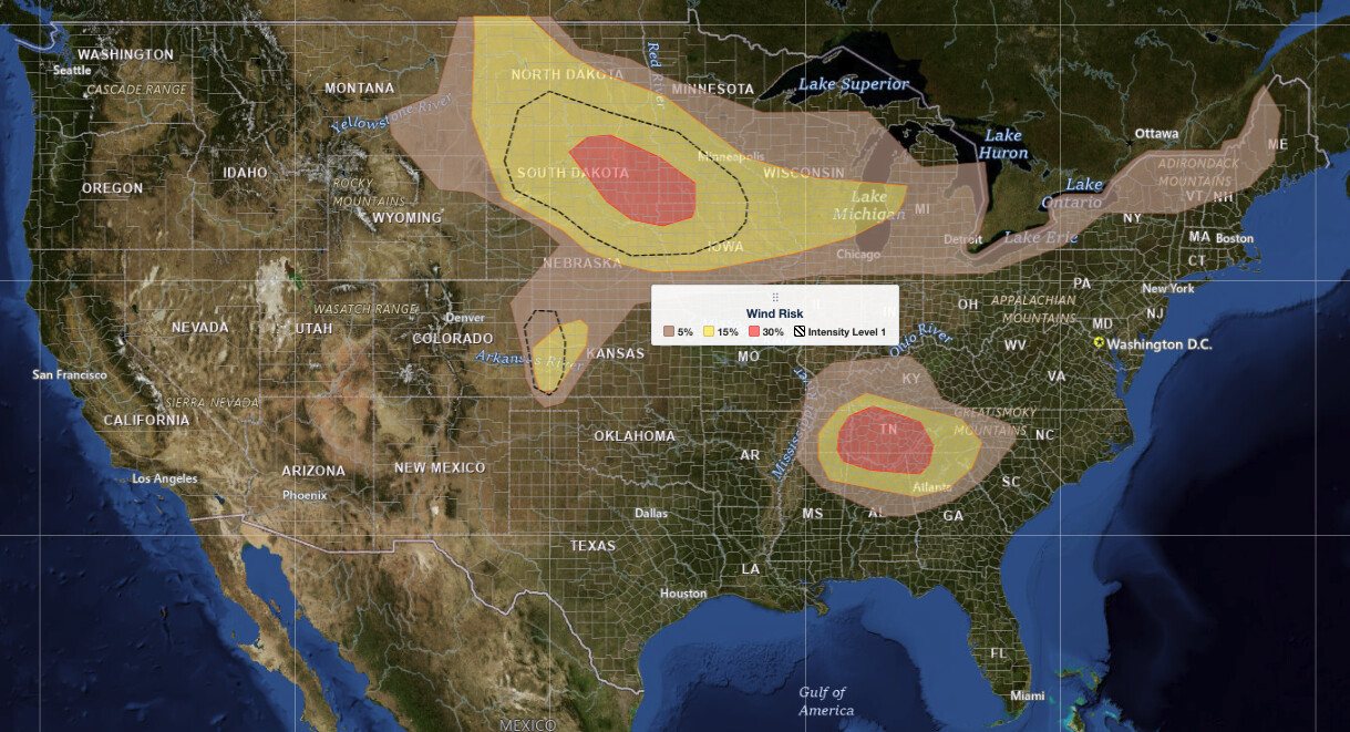
Northern Plains severe thunderstorms are the top weather story on Thursday, July 2, 2026, as the NOAA Storm Prediction Center has placed portions of the northern Plains into the Upper Midwest under an Enhanced Risk, the third of five severe categories. SPC warns that supercells capable of large to very large hail and damaging wind gusts exceeding 75 mph are possible, with the threat stretching east toward the Great Lakes and Midwest through the afternoon and evening.
Key points:
- Enhanced Risk (level 3 of 5) covers portions of the northern Plains into the Upper Midwest.
- Supercells could produce large to very large hail and wind gusts of 75+ mph.
- A Slight Risk (level 2 of 5) extends to the Upper Great Lakes, Midwest, and southern Appalachians.
- SPC hazard probabilities: large hail 15%, damaging wind 30%, tornado 2%.
- Storms are expected to develop this afternoon and increase in coverage through the evening.
Where and When the Highest Threat Is Focused
The heart of the northern Plains severe thunderstorms threat sits across the Dakotas, where a surface low centered over eastern Montana into the western Dakotas anchors the setup. A surface boundary extends from that low pressure center into the Upper Midwest, and afternoon storm development is expected to blossom near that boundary. Early morning convection in North Dakota, tied to energy moving out of Montana, may shift the exact position of that boundary before the main afternoon event gets underway.
Beyond the Enhanced Risk zone in the northern Plains and Upper Midwest, the SPC also placed the Upper Great Lakes, broader Midwest, and southern Appalachians under a Slight Risk, the second of five severe categories. SPC uses a five-tier system to communicate severe weather potential; you can explore how each outlook risk tier works for a full breakdown. Isolated strong to severe storms are additionally possible across the Tennessee Valley, central High Plains, and parts of the Northeast.
Timing matters here. Coverage should remain relatively limited through midday, then expand significantly during the afternoon and evening as a shortwave trough pushes out of Montana and increases the forcing for storm development. Residents across the Dakotas and into Minnesota and Wisconsin should expect conditions to deteriorate during the afternoon commute window and continue into the night as northern Plains severe thunderstorms track east.
Meteorologist’s Take
The large-scale setup features a trough digging across the western United States while a strong ridge dominates the eastern U.S. The zone in between, right over the central and northern Plains, is where multiple shortwave troughs are rotating through the flow. Think of a shortwave as a small disturbance embedded in the jet stream that can trigger rapid storm development when it moves over a region already primed with heat and moisture. Today, steep temperature lapse rates from the surface into the mid-levels, combined with strong daytime heating, will generate moderate to strong instability across the northern High Plains.
Deep-layer wind shear of 40 to 45 knots will organize that instability into supercell thunderstorms initially. Supercells are rotating, long-lived storms that are especially efficient at producing large hail and can generate violent winds. The SPC notes that shear oriented parallel to any outflow boundary, along with large dew point spreads that favor outflow-dominated storms, will likely cause some supercells to evolve into clusters or bowing segments. That storm-mode transition is what drives the most serious wind threat: one or more of those bowing segments could produce significant gusts exceeding 75 mph as they push south and east across the region through the evening hours.
Across the southern Appalachians and Tennessee Valley, the pattern is different but still capable of producing isolated severe storms, contributing to the Slight Risk designation in that region.
How to Stay Safe from Northern Plains Severe Thunderstorms Today
The primary hazards tied to today’s northern Plains severe thunderstorms are large hail and destructive straight-line wind gusts, with a lower but real tornado probability of 2 percent according to the SPC. If you are in the Dakotas, Minnesota, or surrounding areas, bring vehicles and outdoor furniture inside before afternoon storms develop. Hail large enough to crack windshields and damage roofs is possible.
Wind gusts above 75 mph can snap trees, down power lines, and make driving dangerous. If severe thunderstorm warnings are issued for your county, move away from windows, avoid using large open structures like barns or metal buildings, and pull off the road safely if visibility drops or debris is moving. Even if a tornado watch is not issued, bowing line segments can produce tornado-strength damage with little warning. Stay connected to active weather alerts for your area throughout the afternoon and evening, and make sure your phone’s wireless emergency alerts are enabled. Check your local weather forecast for updated storm timing before heading outdoors.
The threat is real and worth taking seriously. Plan outdoor activities for the morning hours and have a sheltering plan ready well before storms arrive this afternoon.
Sources:
Get Lightning Detection Alerts for Your Location
When dangerous lightning is detected near your area, iAlert sends you an immediate notification by email, text message, or phone call, so you know when to seek shelter and when it is safe to head back outside.
Sign Up for Lightning Detection Alerts →

