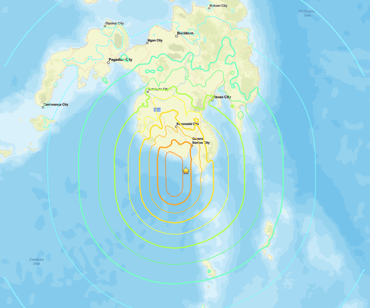
 Philippines earthquake activity struck hard on June 7, 2026, when a magnitude 7.8 event occurred approximately 26 kilometers southwest of Kablalan in the southern Philippines. The earthquake hit at 23:37 UTC at a depth of about 55 kilometers, placing it in the intermediate-depth range that can spread strong shaking across a wide geographic footprint.
What the USGS Data Shows
The U.S. Geological Survey assigned an Orange PAGER alert to this Philippines earthquake, indicating a significant probability of casualties and economic losses requiring a notable humanitarian response. The ShakeMap estimated peak shaking intensity at Modified Mercalli Intensity (MMI) VIII, a level described as “severe,” where poorly built structures can suffer major damage and even well-constructed buildings sustain moderate harm. Felt reports submitted through the USGS “Did You Feel It?” system reached as high as MMI IX in some locations, meaning a subset of people near the epicenter experienced “violent” shaking. The epicenter coordinates place the event at 5.592 degrees North, 125.047 degrees East, in a seismically active region of Mindanao.Why This Region Sees Major Philippines Earthquake Events
The southern Philippines sits at the intersection of several tectonic plates and microplates, including the Philippine Sea Plate and the Sunda Plate. The Philippine Trench, one of the deepest oceanic trenches on Earth, runs along the eastern coast of Mindanao and generates frequent seismic stress in this zone. This tectonic setting makes a large Philippines earthquake a recurring and serious hazard for communities across the island. A depth of 55 kilometers classifies this event as intermediate depth. Shallow quakes (under 70 km) still carry most of the destructive energy to the surface, so 55 km depth does not significantly dampen ground motion compared to truly deep events. Intermediate-depth quakes in subduction zones can also trigger aftershock sequences that extend hazards for days or weeks. An M 7.8 releases roughly 45 times more energy than an M 7.0. At that energy level, ground shaking can rupture pipelines, collapse unreinforced masonry, and trigger landslides on steep terrain, all of which are concerns in the hilly interior of Mindanao.Meteorologist’s Take
Earthquakes are not weather, but their aftermath often is. Strong shaking destabilizes hillslopes, and if heavy rainfall follows, those slopes can fail as landslides and debris flows. The Philippines experiences a monsoon season that can deliver intense precipitation at the worst possible moment, when terrain is already loosened by the quake. That overlap between seismic damage and weather-driven hazards is what we watch most closely after an event like this.What Comes Next
Coastal communities near a large Philippines earthquake need to monitor tsunami warnings immediately after a major event. Submarine fault movement at subduction zones like the Philippine Trench can displace the water column and send waves toward shore within minutes. Official guidance from PHIVOLCS and the Pacific Tsunami Warning Center should be followed without delay.Aftershock probability following an M 7.8 is high. Statistical models suggest dozens of aftershocks above M 5.0 are possible in the weeks ahead, each capable of causing additional structural failures in buildings already weakened by the mainshock.
How to Stay Safe During a Philippines Earthquake
- Drop, Cover, and Hold On during shaking. Move away from windows, exterior walls, and heavy furniture.
- After a major Philippines earthquake near the coast, move immediately to higher ground without waiting for an official tsunami warning.
- Inspect your building for structural damage before re-entering. Aftershocks can collapse already-weakened structures.
- Keep a go-bag ready with water, medications, documents, and a battery-powered radio.
- Monitor official alerts from PHIVOLCS, local government, and international agencies.
- Stay informed about evolving hazards by checking active weather and hazard alerts on iAlert for any related watches or warnings in your area.
Sources: