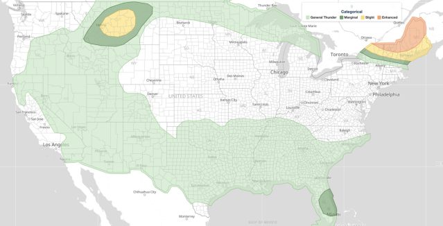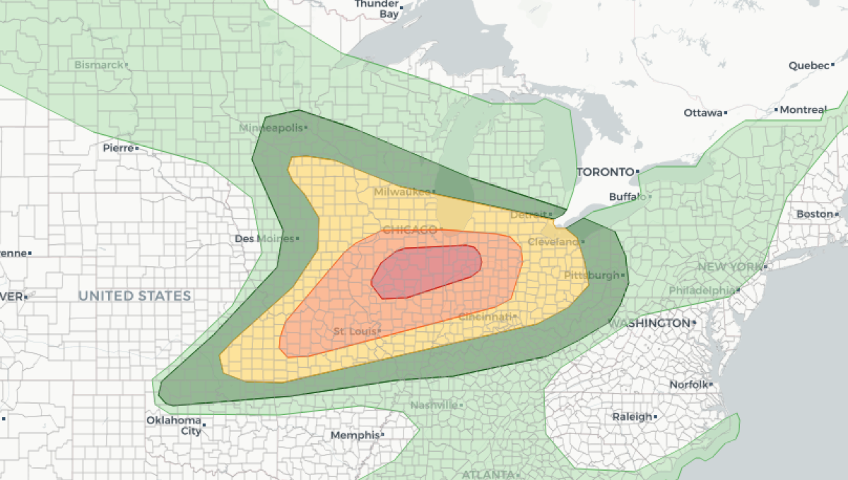
The severe weather outlook for June 17, 2026 places a Moderate risk, level 4 of 5, across parts of the Midwest, centered on the Chicago metro and northern Illinois, according to the NOAA Storm Prediction Center’s June 16 Day 2 Convective Outlook. Tornadoes, very large hail, and damaging straight-line winds are possible from southern Wisconsin through eastern Iowa and into northern Indiana.
Key points:
- Risk level: Enhanced to Moderate (3 to 4 of 5)
- Where: Midwest, centered on Chicago and northern Illinois
- When: Afternoon through overnight, June 17, 2026
- Main threats: Tornadoes, very large hail, damaging winds
The SPC releases these outlooks twice daily, and the 0600 UTC issuance represents the forecasters’ best assessment of convective hazards one day in advance, giving emergency managers and the public a critical planning window.
What the SPC Day 2 Convective Outlook Covers
The SPC’s convective outlook system categorizes severe weather risk on a scale from General Thunderstorms through Marginal, Slight, Enhanced, Moderate, and High. Each category reflects the probability that severe weather events, including tornadoes, hail at least one inch in diameter, or wind gusts of 58 mph or greater, will occur within 25 miles of any point in a given area.
The Day 2 timeframe is particularly important because it allows residents, local governments, and utilities to make preparations before watches and warnings are issued the following day. When the severe weather outlook escalates to Enhanced or higher, history shows that widespread, long-track events become considerably more likely.
Thunderstorm threats highlighted in these outlooks can include supercells capable of producing large hail and tornadoes, squall lines that generate destructive wind gusts, and mesoscale convective systems that can persist overnight and move into densely populated areas.
Understanding the Hazards in a Severe Weather Outlook
Tornadoes remain the most dangerous product of supercell thunderstorms. Even a brief tornado rated EF1 on the Enhanced Fujita scale, with winds of 86 to 110 mph, can destroy roofs, snap trees, and overturn vehicles. Tornadoes can develop with little visible warning, which is why advance outlooks are so valuable.
Large hail, another key hazard in any severe weather outlook, forms when strong updrafts carry water droplets repeatedly above the freezing level inside a thunderstorm. Hailstones of two inches or larger can cause serious injury and quickly total vehicles or destroy crops. Even hail near the one-inch threshold causes significant damage to roofs and skylights.
Damaging wind events, sometimes called derechos when they extend over hundreds of miles, can knock out power to millions of customers and bring down trees onto homes and roadways. These wind-producing events are often underestimated by the public compared to tornadoes, yet they account for a large share of severe weather fatalities each year.
Meteorologist’s Take
This is a setup that earns its Enhanced to Moderate billing. The forecasters in Norman, Oklahoma combine high-resolution numerical models, atmospheric soundings, and synoptic pattern recognition to produce these outlooks.
A Moderate risk issued a full day in advance means the ingredients are already coming together on the models. For June 17 over the Midwest, that points to strong wind shear, ample instability, and a clear lifting mechanism aligning across northern Illinois, southern Wisconsin, and the surrounding region.
When the SPC commits to a Moderate risk at the Day 2 range, it is signaling confidence that organized, potentially long-track severe weather is on the table, not just isolated storms. Supercells are the main concern early, capable of producing tornadoes and very large hail, with the threat trending toward damaging winds as storms grow upscale into clusters or a line through the evening.
Residents from Chicago and Milwaukee through the St. Louis corridor should treat the window between this severe weather outlook and the next morning’s Day 1 products as a preparation window, not a wait-and-see interval. Use that lead time to charge devices, identify a shelter location, and review your warning plan.
Fire weather concerns are also noted elsewhere in this SPC product cycle, a reminder that dry, windy conditions away from the thunderstorm threat zones carry their own serious risks during the warm season.
How to Stay Safe During a Severe Weather Outlook
- Monitor active weather alerts and watches throughout the day so you know the moment conditions escalate in your area.
- Identify a sturdy interior shelter, such as a basement or an interior room on the lowest floor, before storms arrive.
- Keep a battery-powered or hand-crank weather radio charged and accessible in case power is lost.
- If large hail is forecast, move vehicles into a garage or covered parking structure ahead of the storm.
- Stay off roads during active severe thunderstorm events. Most storm-related vehicle deaths occur when drivers attempt to outrun or drive through severe weather.
You can also check your local weather forecast for the latest updates specific to your community as the event approaches. The severe weather outlook is a regional tool, and localized forecasts will refine timing and intensity as the event draws closer.
The severe weather outlook from the SPC is one of the most reliable early-warning products available to the public. Tracking it through platforms like iAlert weather alerts and notifications ensures you receive timely updates and can act before watches or warnings are in effect. A severe weather outlook is not a guarantee of destruction, but it is a clear signal to pay attention and be ready.
Sources: