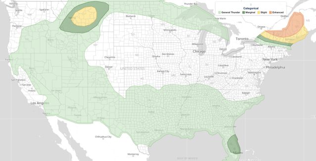
Severe thunderstorms June 23 are the focus of a Day 1 Convective Outlook issued by the NOAA Storm Prediction Center (SPC), valid for Tuesday, June 23, 2026. The SPC has placed portions of the United States under an Enhanced Risk, the third of five severe categories (level 3 of 5), representing a meaningful threat of damaging storms.
Key points:
- SPC issued an Enhanced Risk (level 3 of 5) for June 23, 2026.
- Four risk tiers are depicted: General Thunderstorms, Marginal, Slight, and Enhanced.
- Enhanced Risk is the third of five severe-weather categories on the SPC scale.
- Residents in higher-risk zones should monitor active alerts and local forecasts closely.
What the SPC’s June 23 Outlook Covers
The SPC’s Day 1 Outlook for June 23, 2026 outlines four zones of increasing storm potential across the country. The Enhanced Risk for severe thunderstorms June 23 is centered over the central High Plains near the Wyoming, Colorado, and Nebraska borders. The lowest tier depicted is a general-thunderstorm area, marking where non-severe convection is expected. Moving up the scale, a Marginal Risk (level 1 of 5) and a Slight Risk (level 2 of 5) cover broader areas, with isolated to scattered severe storms possible in those zones.
At the top of Tuesday’s outlook sits the Enhanced Risk (level 3 of 5). SPC uses a five-tier system to communicate severe weather potential, and you can learn how each category is defined in the iAlert guide to SPC outlook risk categories. An Enhanced Risk signals that organized severe thunderstorms are likely, with multiple hazard types possible across a concentrated area.
Severe Thunderstorms June 23: Why Enhanced Risk Matters
Severe thunderstorms June 23 carrying an Enhanced Risk designation are worth taking seriously. At level 3 of 5, this tier sits above Marginal and Slight but below the Moderate (level 4 of 5) and High (level 5 of 5) categories. In practical terms, it means conditions are favorable for well-organized storm clusters or supercells capable of producing large hail, damaging straight-line winds, and tornadoes.
The Enhanced category typically appears when atmospheric ingredients, such as strong wind shear, ample moisture, and a triggering boundary, are expected to combine in a focused region. Storms in these setups can produce rapid intensification, making the window between storm initiation and severe impacts relatively short for those in affected areas.
Meteorologist’s Take
An Enhanced Risk on a Day 1 outlook is not issued routinely. The SPC places it only when forecasters have a higher degree of confidence in both the coverage and intensity of severe storms. When four distinct risk tiers appear in a single outlook, from General Thunderstorms up through Enhanced, that spread signals a complex storm environment with a clear gradient of threat across the region.
For residents inside or near the Enhanced Risk zone, the key concern is the speed of storm development. Enhanced-level setups can produce severe weather quickly after convective initiation, leaving little time to react. Checking live radar and active alerts frequently throughout the day is the most reliable way to track storm movement in real time on June 23.
How to Stay Safe During Severe Thunderstorms June 23
Severe thunderstorms June 23 demand advance preparation before storms arrive. First, identify a sturdy interior shelter location in your home or workplace away from windows. Second, charge mobile devices and have a battery-powered weather radio ready in case of power loss. Third, avoid driving through areas with active warnings, as flooding and debris can make roads dangerous within minutes of storm passage.
Stay connected to active weather alerts for your area throughout the day. If a Severe Thunderstorm Warning or Tornado Warning is issued for your county, move to shelter immediately and do not wait to see the storm. Severe thunderstorms June 23 can escalate quickly under Enhanced Risk conditions, so acting early is critical.
You can also pull up your local weather forecast to see the latest timing and storm-mode expectations for your specific location ahead of the afternoon and evening hours.
Sources: