View All Articles

2008 Hurricane Names | 2008 National Hurricane Center Tropical Cyclone Reports

Hurricanes are named alphabetically from a predetermined list beginning the letter “A” through “W”, excluding names that begin with “Q” or “U.” A storm is first named by the National Hurricane Center when the system becomes a tropical storm and the name remains as it develops into a hurricane or until it dissipates. The most devastating hurricane names are retired and another name replaces it.  

2008 Hurricane Names:

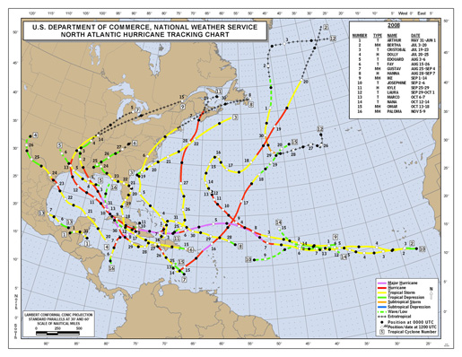
Arthur Bertha Cristobal Dolly Edouard Fay Gustav Hanna Ike Josephine Kyle Laura Marco Nana Omar Paloma Rene Sally Teddy Vicky Wilfred 2008 Named Hurricane Tracks
 

2008 National Hurricane Center Tropical Cyclone Reports:

  • Tropical Storm Arthur – MSWord
  • Hurricane Bertha – MSWord
  • Tropical Storm Cristobal  MSWord
  • Hurricane Dolly – MSWord
  • Tropical Storm Edouard – MSWord
  • Tropical Storm Fay – MSWord
  • Hurricane Gustav – MSWord
  • Hurricane Hanna – MSWord
  • Hurricane Ike – MSWord
  • Tropical Storm Josephine – MSWord
  • Hurricane Kyle – MSWord
  • Tropical Storm Laura – MSWord
  • Tropical Storm Marco – MSWord
  • Tropical Storm Nana – MSWord
  • Hurricane Omar – MSWord
  • Tropical Depression Sixteen – MSWord
  • Hurricane Paloma – MSWord
Click here to review past Tropical Cyclone Reports  

This entry was posted in Weather Articles and tagged , , , , , , , , , , , , , , , , . Bookmark the permalink.

Leave a Reply

Read More

Southern Plains severe storms SPC Day 1 outlook for October 14, 2026, with a Slight Risk over Oklahoma and West Texas and Marginal Risk areas fromTulsa to the Mid-Atlantic

Southern Plains Severe Storms: SPC Slight Risk for Oklahoma and West Texas on October 14, 2026

Southern Plains severe storms are the main severe weather concern across the country on Wednesday, October 14, 2026, with the NOAA Storm Prediction Center placing Oklahoma City, Lawton and Ardmore in Oklahoma, along with Midland, Odessa…

Read More

Panama earthquake USGS ShakeMap showing M7.7 epicenter near Pitaloza Arriba on the Azuero Peninsula, October 9, 2026

Panama Earthquake: Magnitude 7.7 Strikes Near Pitaloza Arriba, USGS Issues RED Alert

USGS ShakeMap of the M7.7 Panama earthquake. The star marks the epicenter; red and orange contours show the strongest estimated shaking. Source: U.S. Geological Survey. A powerful Panama earthquake struck the Azuero Peninsula on Friday, October…

Read More

Hurricane Isaias landfall forecast track map showing the NHC cone from the Gulf of Mexico to the Alabama and Florida Panhandle coast with Gulf Coast warnings, October 9, 2026

Hurricane Isaias Landfall Expected Tonight on the Northern Gulf Coast as Storm Nears Major Hurricane Strength

Hurricane Isaias position at 7 AM CDT Friday, October 9, 2026, with the NHC forecast track and cone toward the northern Gulf Coast and active coastal and inland warnings. Map: iAlert.com Hurricane Isaias landfall is expected…

Read More

Leave a Reply