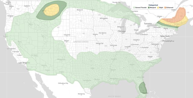
Ozarks severe weather is in the forecast this afternoon and evening on June 26, 2026, as the NOAA Storm Prediction Center has issued a Day 1 Convective Outlook carrying a Slight Risk, the second of five severe categories (level 2 of 5), for parts of the Ozark Plateau into the lower Ohio Valley and across parts of the northern Rockies into the adjacent Great Plains. SPC places the peak hazard probabilities at 15 percent for large hail, 15 percent for damaging wind, and 5 percent for tornadoes within those risk areas.
Key points:
- Slight Risk (level 2 of 5) covers the Ozark Plateau into the lower Ohio Valley.
- A second Slight Risk area spans parts of the northern Rockies into the adjacent Great Plains.
- SPC hazard probabilities: large hail 15%, damaging wind 15%, tornado 5%.
- Threat window runs this afternoon through tonight, June 26, 2026.
- A Marginal Risk surrounds both Slight Risk zones, with General Thunderstorms possible more broadly.
Where the Ozarks Severe Weather Threat Is Focused
The SPC pinpoints two geographically distinct areas of concern. The primary zone covers the Ozark Plateau and extends northeast into the lower Ohio Valley. A separate area of elevated concern stretches across parts of the northern Rockies and into the adjacent Great Plains. Both areas face the prospect of scattered severe thunderstorm development this afternoon into tonight, according to the SPC outlook. SPC uses a five-tier system to communicate severe weather potential, and you can learn how each tier is defined by reading iAlert’s severe weather outlook explainer.
For both zones, a Marginal Risk, the lowest of the five severe tiers (level 1 of 5), wraps the outer edges of the Slight Risk areas, indicating that even where the chance of severe storms is lower, isolated hazards remain possible. Track current watches and warnings on the active weather alerts page as conditions evolve through the day.
Meteorologist’s Take
The setup driving Ozarks severe weather today is a product of two separate but simultaneous patterns. Across the West, a deep upper-level trough is digging southward from the Pacific Northwest through the Great Basin and into the northern Rockies, the kind of large-scale atmospheric dip that organizes storm energy across the high terrain. Separately, downstream of that trough, ridging is building over the northern Great Plains and upper Mississippi Valley, which compresses the active weather zone and channels energy eastward.
In the East, a mid-level trough has already accelerated toward New England and the Canadian Maritimes, leaving behind a broadly flat, westerly flow across the area east of the mid to upper Mississippi Valley. Within that flow, the SPC notes that convectively generated perturbations, small disturbances kicked off by earlier storm clusters, are likely to ripple eastward across the Ozark Plateau and lower Ohio Valley through the Mid-Atlantic during the day and into tonight.
At the surface, a weak low is expected to track northeast of the lower Great Lakes into northern New England while weakening, and a preceding diffuse frontal boundary is expected to overspread the northern Mid-Atlantic. West of the Appalachians, that boundary may be reinforced by thunderstorm outflow and differential surface heating during the afternoon hours. The combination of that boundary, available moisture and instability, and the passing upper-level disturbances is what fuels the Ozarks severe weather window.
Meanwhile, across the high Plains, the SPC anticipates significant surface cyclogenesis centered near southeastern Montana by early Saturday morning, with deepening surface troughing extending southward along the lee of the Rockies. This is the mechanism supporting the separate northern Rockies and adjacent Great Plains risk area. The favored hazards across both areas align with the boundary-driven, multicell storm mode typical of this kind of setup: large hail up to the threshold covered by the 15 percent probability, gusty damaging winds, and a lower but real tornado chance at 5 percent.
How to Stay Safe from Ozarks Severe Weather Today
The primary threats from today’s Ozarks severe weather are large hail and damaging wind gusts. If you are outdoors, move inside a sturdy structure before storms arrive. Hail can reach golf-ball size or larger under the right storm updraft, and wind gusts can down trees and power lines with little warning. Secure or bring inside any lightweight outdoor furniture, umbrellas, or equipment that wind could turn into a projectile.
The 5 percent tornado probability is non-trivial for a Slight Risk day. Know in advance where your lowest-floor, interior shelter is, ideally away from windows. If you are in a mobile home or vehicle, identify a nearby solid structure you can reach quickly. Monitor local forecasts and check the live radar and alerts frequently this afternoon and evening, especially if you are anywhere across the Ozark Plateau, lower Ohio Valley, or the northern Rockies and adjacent Great Plains. Keep a weather app with push notifications active so you receive any tornado or severe thunderstorm warnings the moment they are issued.
Ozarks severe weather situations like today’s can evolve quickly as storm clusters interact with the frontal boundary and afternoon heating peaks. Plan outdoor activities around the early morning hours and be prepared to take shelter by mid-afternoon.
Sources: