
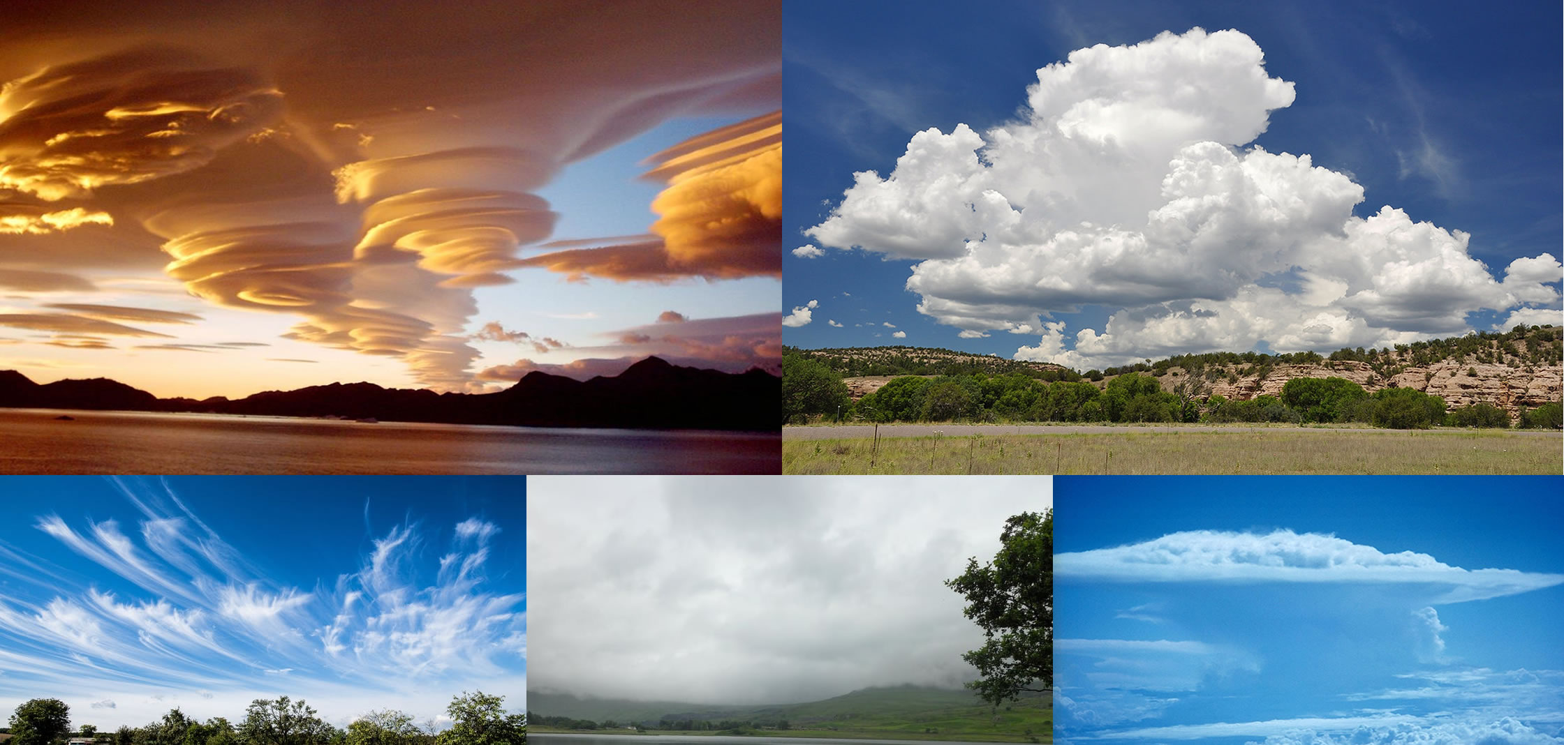
 Looking at the clouds it may appear there are endless cloud types, however you may be surprised to know there are really only 4 core types.? From his Essay of the Modifications of Clouds (1803) Luke Howard divided clouds into three categories; cirrus, cumulus and stratus.
 |
Cirro-form The Latin word ‘cirro’ means curl of hair. Composed of ice crystals, cirro-form clouds are whitish and hair-like. They are often the first clouds to appear in advance of a low pressure area such as a mid-latitude storm system or a tropical system such as a hurricane. |
|---|---|
 |
Cumulo-form Generally detached clouds, they look like white fluffy cotton balls. They show vertical motion or thermal uplift of air taking place in the atmosphere. They are usually dense in appearance with sharp outlines. |
 |
Strato-form From the Latin word for ‘layer’ these clouds are usually broad and fairly wide spread appearing like a blanket. They result from non-convective rising air. They tend to occur along and to the north of warm fronts. |
 |
Nimbo-form Based on his observations, Howard suggested there were modifications of these basic forms between categories. He noticed that clouds often have features of two or more categories; cirrus + stratus, cumulus + stratus, etc. He also designated a special rainy cloud category which combined the three forms Cumulo + Cirro + Stratus. He called this cloud, ‘Nimbus’, the Latin word for rain. |
Combination of the Core Four Cloud Types
Based on his observations, Howard suggested there were modifications (or combinations) of these core clouds between categories. He noticed that clouds often have features of two or more categories; cirrus + stratus, cumulus + stratus, etc. His research served as the starting point for the ten basic types of clouds we observe today. We call these clouds Altocumulus, Altostratus, Cirrus, Cirrocumulus, Cirrostratus, Cumulonimbus, Cumulus, Nimbostratus, Stratocumulus and Stratus. By convention, clouds are vertically divided into three levels; low, middle, and high. Each level is defined by the range of levels at which each type of cloud typically appears. Divided by their height the ten types of clouds are…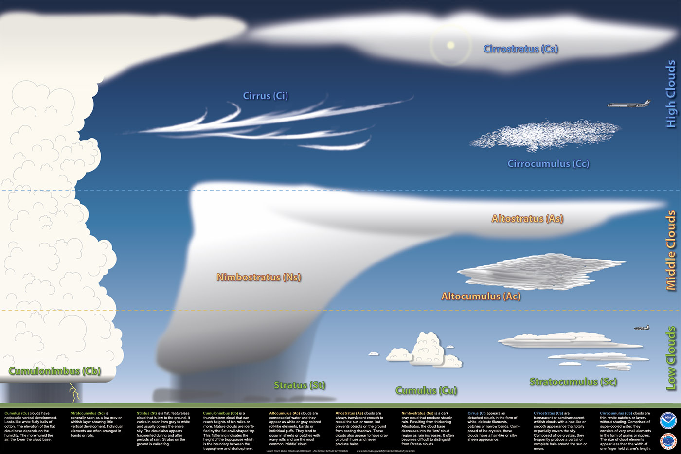 Cirrus (Ci), Cirrocumulus (Cc), and Cirrostratus (Cs) are high level clouds. They are typically thin and white in appearance, but can appear in a magnificent array of colors when the sun is low on the horizon.
Altocumulus (Ac), Altostratus (As), and Nimbostratus (Ns) are mid-level clouds They are composed primarily of water droplets, however, they can also be composed of ice crystals when temperatures are low enough.In Latin, alto means ‘high’ yet Altostratus and Altocumulus clouds are classified as mid-level clouds. ‘Alto’ is used to distinguish between liquid-based clouds. They are ‘high’ relative to their low level liquid-based counterpart clouds Stratus and Cumulus.Altostratus can extend into the high level of clouds. Nimbostratus can extend into the high level as well but the base of the cloud typically decreases into the low level as precipitation continues.
Cumulus (Cu), Stratocumulus (Sc), Stratus (St), and Cumulonimbus (Cb) are low clouds composed of water droplets. Cumulonimbus, with its strong vertical updraft, extends well into the the high level of clouds
Cirrus (Ci), Cirrocumulus (Cc), and Cirrostratus (Cs) are high level clouds. They are typically thin and white in appearance, but can appear in a magnificent array of colors when the sun is low on the horizon.
Altocumulus (Ac), Altostratus (As), and Nimbostratus (Ns) are mid-level clouds They are composed primarily of water droplets, however, they can also be composed of ice crystals when temperatures are low enough.In Latin, alto means ‘high’ yet Altostratus and Altocumulus clouds are classified as mid-level clouds. ‘Alto’ is used to distinguish between liquid-based clouds. They are ‘high’ relative to their low level liquid-based counterpart clouds Stratus and Cumulus.Altostratus can extend into the high level of clouds. Nimbostratus can extend into the high level as well but the base of the cloud typically decreases into the low level as precipitation continues.
Cumulus (Cu), Stratocumulus (Sc), Stratus (St), and Cumulonimbus (Cb) are low clouds composed of water droplets. Cumulonimbus, with its strong vertical updraft, extends well into the the high level of clouds
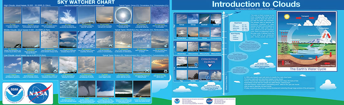
Click Image to Download Cloud Identification Chart


