View All Articles

Criteria For a Tornado Warning

The National Weather Service (NWS) is the official U.S. government agency charged with issuing severe weather watches, warnings, and advisories and is the source used by iAlert.com. When the NWS issues a “Tornado Warning” their decision is based on based on the following criteria….

Tornado Warning is Issued When:

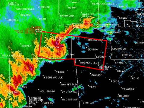
  • A tornado is reported on the ground or is indicated by weather radar
  • A waterspout is headed for landfall
  • A rotating wall cloud, usually one that has strong low-level rotation, is reported.
  • A funnel cloud is reported.

Sample Radar Image Highlighting Tornado Location

  Regardless of the criteria for which a tornado warning is issued under, a tornado warning means there is immediate danger for the warned area and those in the storm path should take cover immediately. Although it is well known that tornados are most common in the mid-west United States, called tornado ally, tornados can and do occur in all 50 states. U.S. tornado warnings are generated through the NWS Advanced Weather Interactive Processing System (AWIPS) and disseminated through various communication channels including iAlert.com, the news media, NOAA Weather Radio, and where present Civil defense sirens are activated. A warning should not be confused with a tornado watch which indicates that conditions are favorable for the formation of tornadoes.

Related Articles:

This entry was posted in Weather Glossary and tagged , , , . Bookmark the permalink.

Leave a Reply

Read More

Ohio Valley severe thunderstorms outlook August 1, 2026: SPC Slight Risk from Cincinnati through Kentucky to north Alabama

Ohio Valley Severe Thunderstorms: Damaging Wind and Tornado Threat From Kentucky to North Alabama, August 1, 2026

Ohio Valley severe thunderstorms are the primary concern for August 1, 2026, as the NOAA Storm Prediction Center has issued a Slight Risk outlook across parts of the Ohio and Tennessee Valleys. The risk corridor starts…

Read More

Extremely critical fire weather risk areas for Saturday, August 1, 2026. Elevated in orange, Critical in red, Extremely Critical in magenta. Source: NOAA Storm Prediction Center.

Extremely Critical Fire Weather Forecast for the Columbia Basin, August 1, 2026

Extremely critical fire weather risk areas for Saturday, August 1, 2026. Elevated in orange, Critical in red, Extremely Critical in magenta. Source: NOAA Storm Prediction Center Day 2 Fire Weather Outlook, mapped by iAlert.com. Extremely critical…

Read More

Ozarks severe thunderstorms Slight Risk area on the NOAA Storm Prediction Center Day 1 categorical outlook map for July 31, 2026

Ozarks Severe Thunderstorms: Slight Risk of Damaging Wind and Hail July 31, 2026

Ozarks severe thunderstorms are the headline hazard for July 31, 2026, as the NOAA Storm Prediction Center has issued a Slight Risk covering parts of the Ozarks and mid Mississippi Valley, with damaging wind gusts and…

Read More

Leave a Reply